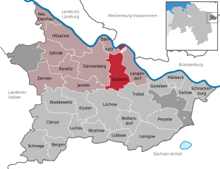
Gusborn (Gusborn)
- municipality of Germany
It seems that "Gusborn" might not be a widely recognized hiking destination or may refer to a specific, lesser-known area. However, if you meant a popular hiking destination or region, here are some general tips for hiking in similar areas:
-
Check Local Trails: Look for local hiking websites or visitor centers that provide information on trails in the area you are interested in.
-
Trail Difficulty: Assess the difficulty level of the trails. It’s important to choose a trail that fits your fitness level and experience.
-
Safety Measures: Always prioritize safety. Inform someone of your hiking plans, carry a first aid kit, and familiarize yourself with the route.
-
Weather Conditions: Check the weather forecast before heading out. Weather can change quickly, so be prepared for any conditions.
-
Leave No Trace: Follow the Leave No Trace principles to minimize your impact on the environment, including packing out all your trash and staying on marked trails.
If you meant a specific location, please provide more details or confirm the name, and I would be happy to give you more focused information!
- Country:

- Postal Code: 29476
- Local Dialing Code: 05865
- Licence Plate Code: DAN
- Coordinates: 53° 4' 59" N, 11° 13' 0" E


- GPS tracks (wikiloc): [Link]
- AboveSeaLevel: 17 м m
- Area: 48.3 sq km
- Population: 1194
- Web site: http://www.dannenberg.de/
- Wikipedia en: wiki(en)
- Wikipedia: wiki(de)
- Wikidata storage: Wikidata: Q638090
- Wikipedia Commons Category: [Link]
- Freebase ID: [/m/02ryh6p]
- Freebase ID: [/m/02ryh6p]
- GeoNames ID: Alt: [3209065]
- GeoNames ID: Alt: [3209065]
- VIAF ID: Alt: [240048488]
- VIAF ID: Alt: [240048488]
- OSM relation ID: [1821886]
- OSM relation ID: [1821886]
- GND ID: Alt: [4325315-5]
- GND ID: Alt: [4325315-5]
- German municipality key: 03354008
- German municipality key: 03354008

