Hémévillers (Hémévillers)

- commune in Oise, France
- Country:

- Postal Code: 60190
- Coordinates: 49° 27' 48" N, 2° 40' 25" E


- GPS tracks (wikiloc): [Link]
- Area: 6.93 sq km
- Population: 449
- Web site: http://www.hemevillers.fr
- Wikipedia en: wiki(en)
- Wikipedia: wiki(fr)
- Wikidata storage: Wikidata: Q1346727
- Wikipedia Commons Category: [Link]
- Freebase ID: [/m/03qg8g8]
- GeoNames ID: Alt: [6438749]
- SIREN number: [216003053]
- BnF ID: [15267546t]
- INSEE municipality code: 60308
Shares border with regions:

Francières
- commune in Oise, France
- Country:
- Postal Code: 60190
- Coordinates: 49° 26' 54" N, 2° 40' 47" E
- GPS tracks (wikiloc): [Link]
- Area: 8.23 sq km
- Population: 549

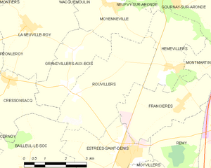
Rouvillers
- commune in Oise, France
- Country:
- Postal Code: 60190
- Coordinates: 49° 27' 8" N, 2° 36' 34" E
- GPS tracks (wikiloc): [Link]
- Area: 11.88 sq km
- Population: 274
- Web site: [Link]


Montmartin
- commune in Oise, France
- Country:
- Postal Code: 60190
- Coordinates: 49° 27' 50" N, 2° 41' 37" E
- GPS tracks (wikiloc): [Link]
- Area: 3.33 sq km
- Population: 257
- Web site: [Link]


Moyenneville
- commune in Oise, France
- Country:
- Postal Code: 60190
- Coordinates: 49° 29' 26" N, 2° 38' 11" E
- GPS tracks (wikiloc): [Link]
- AboveSeaLevel: 78 м m
- Area: 7.19 sq km
- Population: 631
- Web site: [Link]


Gournay-sur-Aronde
- commune in Oise, France
- Country:
- Postal Code: 60190
- Coordinates: 49° 29' 33" N, 2° 40' 27" E
- GPS tracks (wikiloc): [Link]
- Area: 14.71 sq km
- Population: 584