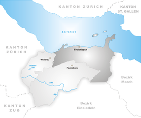
Höfe District (Bezirk Höfe)

- district in Switzerland
 Hiking in Höfe District
The Höfe District, located in Switzerland, offers a variety of hiking opportunities that showcase the beautiful landscapes of the region. While the specific trails may vary depending on factors like weather conditions and seasonal accessibility, here are a few highlights about hiking in this picturesque area:
-
Scenic Views: The Höfe District features rolling hills, lush forests, and stunning views of the surrounding mountains, providing a fantastic backdrop for your hikes.
-
Trail Network: There are numerous well-marked trails suited for all levels of hikers, from leisurely walks to more strenuous routes. Some trails also provide access to nearby vantage points, where you can enjoy panoramic views of Lake Zurich and the Alps.
-
Flora and Fauna: The area is rich in biodiversity. During your hike, you might encounter various plant species and wildlife typical of the Swiss landscape, making it a great spot for nature lovers and photography enthusiasts.
-
Cultural Experience: Some trails lead through charming villages and past historical sites, giving hikers a chance to experience the local culture and perhaps sample some regional cuisine.
-
Accessibility: The Höfe District is generally accessible via public transport, making it easy to get to trailheads. Trains and buses connect the area with larger cities, allowing for convenient hiking day trips.
-
Safety and Preparation: Always check the weather conditions before heading out and make sure you have the appropriate gear (hiking shoes, water, snacks, a map or GPS) for your chosen trail. It's also wise to start early to allow enough time for your hike.
-
Local Hiking Groups: Consider joining local hiking groups for guided hikes. This can be a great way to meet people and learn more about the area from experienced hikers.
Before you plan your hiking trip, double-check local resources, such as hiking websites or tourist information centers, for up-to-date trail conditions and recommendations. Enjoy your hiking adventure in the Höfe District!
- Country:

- Capital: Wollerau
- Licence Plate Code: SZ
- Coordinates: 47° 11' 0" N, 8° 43' 0" E


- GPS tracks (wikiloc): [Link]
- AboveSeaLevel: 584 м m
- Area: 44.4 sq km
- Web site: http://www.hoefe.ch/
- Wikipedia en: wiki(en)
- Wikipedia: wiki(de)
- Wikidata storage: Wikidata: Q74823
- Wikipedia Commons Category: [Link]
- Freebase ID: [/m/0g05w_]
- GeoNames ID: Alt: [6458848]
- archINFORM location ID: [42720]
- HDS ID: [7418]
- Flags of the World ID: [ch-sz-ho]
Includes regions:


Wollerau
- municipality in Switzerland
Hiking in Wollerau
Wollerau is a charming municipality located on the shores of Lake Zurich in Switzerland, and it offers a variety of hiking opportunities that cater to different skill levels and preferences. Nestled between hills and the lake, the surrounding area boasts picturesque landscapes, lush forests, and panoramic views....
- Country:
- Postal Code: 8832
- Local Dialing Code: 043; 044
- Licence Plate Code: SZ
- Coordinates: 47° 11' 17" N, 8° 42' 7" E
- GPS tracks (wikiloc): [Link]
- AboveSeaLevel: 597 м m
- Area: 6.50 sq km
- Population: 7101
- Web site: [Link]


Feusisberg
- municipality in Switzerland
Hiking in Feusisberg
Feusisberg is a beautiful area located in the Swiss canton of Schwyz, known for its stunning landscapes and excellent hiking opportunities. Here are some key highlights to keep in mind when planning a hiking trip in this region:...
- Country:
- Postal Code: 8835
- Local Dialing Code: 044; 043
- Licence Plate Code: SZ
- Coordinates: 47° 10' 29" N, 8° 43' 53" E
- GPS tracks (wikiloc): [Link]
- AboveSeaLevel: 802 м m
- Area: 17.56 sq km
- Population: 5272
- Web site: [Link]

Freienbach
- municipality in the canton of Schwyz, Switzerland
Hiking in Freienbach
Freienbach, located in the canton of Schwyz in Switzerland, offers beautiful hiking opportunities with stunning views of Lake Zurich and the surrounding mountains. Here are some highlights and tips for hiking in the area:...
- Country:
- Postal Code: 8807
- Local Dialing Code: 055
- Licence Plate Code: SZ
- Coordinates: 47° 11' 45" N, 8° 46' 16" E
- GPS tracks (wikiloc): [Link]
- AboveSeaLevel: 463 м m
- Area: 20.30 sq km
- Population: 16269
- Web site: [Link]