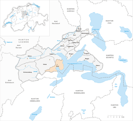
Hergiswil (Hergiswil)

- municipality in the canton of Nidwalden, Switzerland
 Hiking in Hergiswil
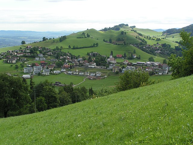
Hergiswil is a charming village located on the shores of Lake Lucerne in Switzerland, surrounded by beautiful mountains and stunning landscapes, making it a great destination for hiking enthusiasts. Here are some key points to consider when hiking in Hergiswil:
Trail Options
-
Niesen Trail: The Niesen, also known as the "Swiss Pyramid," offers panoramic views and is a popular hiking destination. The trail is well-marked and provides a mix of challenging ascents and gentle paths.
-
Pilatus Region: Just a short distance away, Pilatus offers various trails suited for different skill levels. You can take the cogwheel train or the aerial cableway to the top and then enjoy the various hiking trails that lead through breathtaking landscapes.
-
Mt. Rigi: Known as the "Queen of the Mountains," Rigi provides numerous routes starting from nearby towns, including Hergiswil. The trails offer stunning views of the surrounding mountains and Lake Lucerne.
-
Säntis Trail: If you're up for a challenge, consider exploring this more difficult trail. The ascent provides spectacular views, and you can enjoy the unique flora and fauna along the way.
Trail Difficulty
Hiking trails around Hergiswil vary in difficulty from easy lakeside walks to challenging mountain hikes. Be sure to choose trails that match your fitness and experience level, and always be prepared for changing weather conditions.
Preparation
- Gear: Wear sturdy hiking boots, and dress in layers to accommodate for temperature changes.
- Navigation: Carry a map or use a hiking app to keep track of trails; many areas are well-marked, but it's always good to be prepared.
- Water and Snacks: Bring enough water and snacks, especially for longer hikes.
Scenic Highlights
- Lake Views: Many trails offer stunning views of Lake Lucerne, along with its surrounding mountains, making the hikes particularly scenic.
- Flora and Fauna: Depending on the season, you can witness a variety of plants and wildlife, including wildflowers in spring and diverse bird species.
Accessibility
Hergiswil is easily accessible by train or car, making it convenient for day trips. There are also accommodations available if you wish to extend your stay for longer hikes.
Safety Tips
- Always inform someone of your hiking plans and expected return time.
- Keep an eye on the weather forecast before heading out.
- Hike with a partner if possible and take a mobile phone for emergencies.
Exploring the hiking trails around Hergiswil is an excellent way to experience the natural beauty of Switzerland. With breathtaking views, diverse landscapes, and trails for all skill levels, it's an area well worth visiting for any hiking enthusiast.
- Country:

- Postal Code: 6052
- Local Dialing Code: 041
- Licence Plate Code: NW
- Coordinates: 46° 59' 8" N, 8° 16' 21" E


- GPS tracks (wikiloc): [Link]
- AboveSeaLevel: 1121 м m
- Area: 17.00 sq km
- Population: 5715
- Web site: http://www.hergiswil.ch
- Wikipedia en: wiki(en)
- Wikipedia: wiki(de)
- Wikidata storage: Wikidata: Q570969
- Wikipedia Commons Category: [Link]
- Freebase ID: [/m/01v28w]
- GeoNames ID: Alt: [7286067]
- VIAF ID: Alt: [314807923]
- OSM relation ID: [1683080]
- GND ID: Alt: [4322067-8]
- Library of Congress authority ID: Alt: [n78096627]
- MusicBrainz area ID: [002d60c4-bfe8-4f8b-b620-6d7bfdbd0f6b]
- HDS ID: [753]
- Swiss municipality code: [1507]
Shares border with regions:

Horw
- municipality in the canton of Lucerne, Switzerland
Hiking in Horw
Horw is a picturesque municipality located in the canton of Lucerne, Switzerland, known for its stunning natural landscapes and proximity to the Swiss Alps. Hiking in and around Horw offers a variety of trails suited for different skill levels, making it an excellent destination for both novice and experienced hikers....
- Country:
- Postal Code: 6048
- Local Dialing Code: 041
- Licence Plate Code: LU
- Coordinates: 47° 0' 48" N, 8° 18' 39" E
- GPS tracks (wikiloc): [Link]
- AboveSeaLevel: 438 м m
- Area: 20.43 sq km
- Population: 13915
- Web site: [Link]


Kriens
- municipality in the canton of Lucerne, Switzerland
Hiking in Kriens
Kriens is a charming municipality located in the canton of Lucerne in Switzerland, nestled at the foot of the majestic Pilatus mountain range. It offers a variety of hiking opportunities suitable for different skill levels. Here are some highlights and recommendations for hiking in and around Kriens:...
- Country:
- Postal Code: 6010
- Local Dialing Code: 041
- Licence Plate Code: LU
- Coordinates: 47° 1' 15" N, 8° 15' 32" E
- GPS tracks (wikiloc): [Link]
- AboveSeaLevel: 843 м m
- Area: 27.31 sq km
- Population: 26997
- Web site: [Link]

Schwarzenberg
- municipality in the canton of Lucerne, Switzerland
Hiking in Schwarzenberg
Schwarzenberg, nestled in the beautiful Lucerne region of Switzerland, offers a variety of hiking opportunities that cater to different skill levels and preferences. The area is known for its stunning landscapes, characterized by rolling hills, lush forests, and picturesque views of the surrounding mountains....
- Country:
- Postal Code: 6103
- Local Dialing Code: 041
- Licence Plate Code: LU
- Coordinates: 47° 0' 51" N, 8° 10' 24" E
- GPS tracks (wikiloc): [Link]
- AboveSeaLevel: 838 м m
- Area: 39.31 sq km
- Population: 1690
- Web site: [Link]


Stansstad
- municipality in Switzerland
Hiking in Stansstad
Stansstad, located in the canton of Nidwalden in Switzerland, offers a variety of stunning hiking opportunities. Nestled between Lake Lucerne and the surrounding mountains, it's an ideal destination for both casual walkers and experienced hikers....
- Country:
- Postal Code: 6362
- Local Dialing Code: 041
- Licence Plate Code: NW
- Coordinates: 46° 58' 49" N, 8° 20' 20" E
- GPS tracks (wikiloc): [Link]
- AboveSeaLevel: 436 м m
- Area: 17.11 sq km
- Population: 4494
- Web site: [Link]

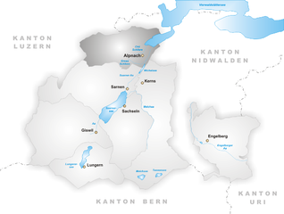
Alpnach
- municipality in Switzerland
Hiking in Alpnach
Alpnach, located in central Switzerland near Lake Alpnach and the foothills of the Swiss Alps, offers a range of hiking opportunities for outdoor enthusiasts. The area features stunning natural beauty, from lush forests and rolling hills to breathtaking alpine views....
- Country:
- Postal Code: 6055
- Local Dialing Code: 041
- Licence Plate Code: OW
- Coordinates: 46° 57' 0" N, 8° 13' 51" E
- GPS tracks (wikiloc): [Link]
- AboveSeaLevel: 1039 м m
- Area: 56.98 sq km
- Population: 6024
- Web site: [Link]