
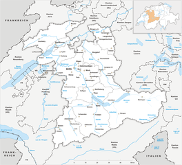
Nidwalden (Kanton Nidwalden)


- canton of Switzerland
 Hiking in Nidwalden
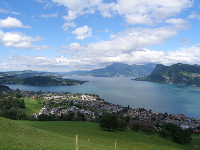
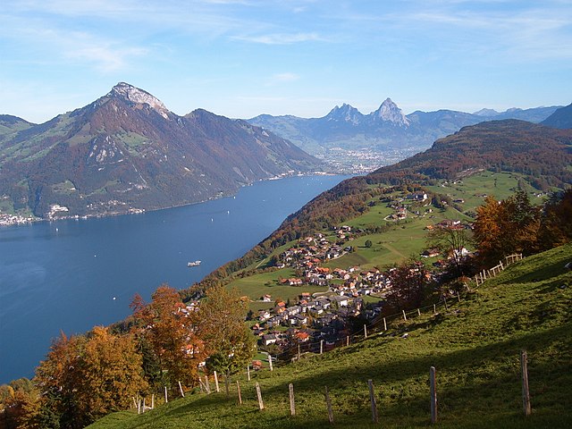
The Canton of Nidwalden, located in central Switzerland, is a true paradise for hikers, offering breathtaking landscapes, diverse trails, and stunning vistas of the surrounding mountains and lakes. Here are some highlights and points of interest for hiking in this beautiful region:
Highlights of Hiking in Nidwalden:
-
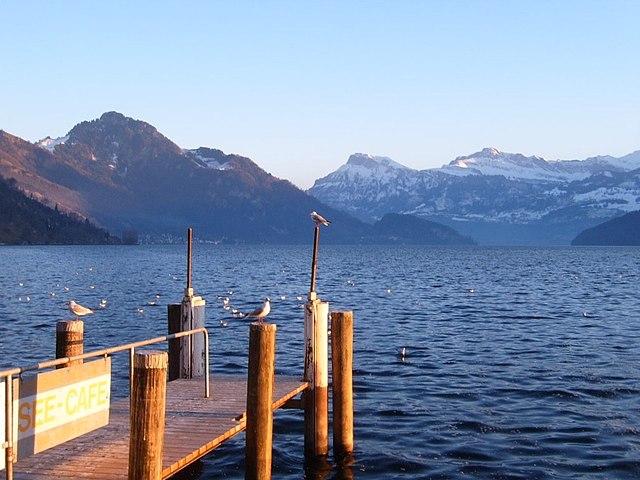
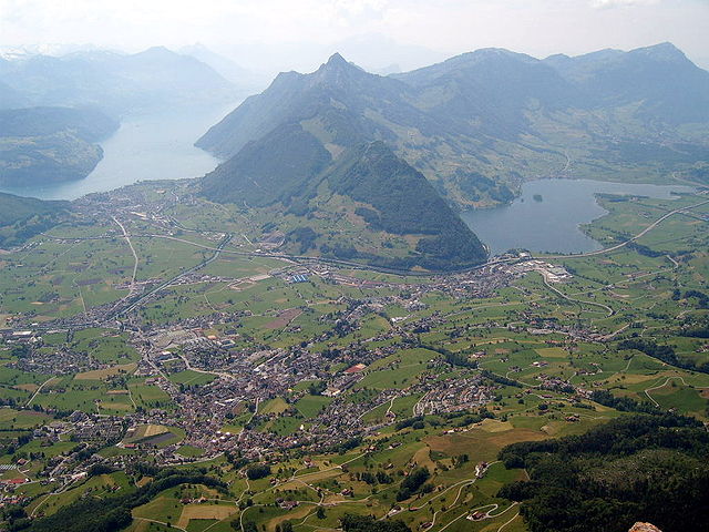
Lake Lucerne: Hiking along the shores of Lake Lucerne provides tranquil views and opportunities for relaxation. The paths are usually well-maintained and suitable for all levels of hikers.
-
Mount Pilatus: Accessible from Nidwalden, this iconic peak offers various hiking routes, ranging from moderate to challenging. The views from the summit are spectacular, allowing hikers to see multiple mountain ranges and the expansive lake below.
-
Engelberg-Titlis: While not directly in Nidwalden, this area is easily accessible and features a range of hiking trails. The scenic Engelberg Valley offers everything from gentle walks to more strenuous mountain treks.
-
Waldstätteweg: This long-distance hiking trail spans several cantons, passing through Nidwalden. It combines cultural heritage with beautiful natural landscapes. The trail showcases picturesque villages, historical sites, and breathtaking panoramas.
-
Vybergrugge Trail: This hike features impressive views of surrounding mountains and Lake Lucerne. It's suitable for moderate hikers and can often be done as a half-day excursion.
Trail Difficulty Levels:
-
Easy Trails: Ideal for families and beginners, featuring gentle inclines and well-marked paths. Examples include lakeside walks or short forest trails.
-
Moderate Trails: These trails involve some elevation and can last several hours. They are suitable for hikers with a bit more experience.
-
Challenging Trails: For experienced hikers seeking adventure, these paths often involve steep ascents, rocky terrain, and longer distances. Proper equipment and a good level of fitness are required.
Practical Tips:
-
Weather: Always check the local weather conditions before embarking on a hike, as mountain weather can change rapidly.
-
Equipment: Wear proper hiking boots and bring necessary gear (like trekking poles, rain gear, and enough water/food) appropriate for the trails you are tackling.
-
Maps and Navigation: While many trails are well-marked, carrying a physical map or GPS can be beneficial, especially in less trafficked areas.
-
Local Resources: Utilize the local tourist information centers for maps, trail advice, and suggestions on current conditions.
Nidwalden's mountainous terrain, along with its charming villages, makes it an excellent destination for hikers of all skill levels. Enjoy the diverse natural beauty, challenge yourself on various trails, and immerse yourself in the tranquility of the Swiss landscape!
- Country:

- Capital: Stans
- Licence Plate Code: NW
- Coordinates: 46° 56' 0" N, 8° 4' 0" E


- GPS tracks (wikiloc): [Link]
- AboveSeaLevel: 454 м m
- Area: 275.85 sq km
- Web site: http://www.nw.ch
- Wikipedia en: wiki(en)
- Wikipedia: wiki(de)
- Wikidata storage: Wikidata: Q12592
- Wikipedia Commons Gallery: [Link]
- Wikipedia Commons Category: [Link]
- Freebase ID: [/m/01v1_3]
- GeoNames ID: Alt: [2659471]
- BnF ID: [12071294v]
- VIAF ID: Alt: [153118096]
- GND ID: Alt: [4062040-2]
- archINFORM location ID: [5881]
- Library of Congress authority ID: Alt: [n82085895]
- MusicBrainz area ID: [77bd0809-b0f9-4eb1-9041-7d10dcc3990e]
- Quora topic ID: [Canton-of-Nidwalden]
- TGN ID: [7003753]
- SUDOC authorities ID: [028992644]
- Encyclopædia Britannica Online ID: [place/Nidwalden]
- Gran Enciclopèdia Catalana ID: [0046031]
- HDS ID: [7411]
- ISNI: Alt: [0000 0001 1498 7000]
- NKCR AUT ID: [ge922685]
- NUTS code: [CH065]
- Ringgold ID: [274249]
- STW Thesaurus for Economics ID: [16968-6]
- ISO 3166-2 code: CH-NW
- FIPS 10-4 (countries and regions): SZ13
Includes regions:

Hergiswil
- municipality in the canton of Nidwalden, Switzerland
Hiking in Hergiswil
Hergiswil is a charming village located on the shores of Lake Lucerne in Switzerland, surrounded by beautiful mountains and stunning landscapes, making it a great destination for hiking enthusiasts. Here are some key points to consider when hiking in Hergiswil:...
- Country:
- Postal Code: 6052
- Local Dialing Code: 041
- Licence Plate Code: NW
- Coordinates: 46° 59' 8" N, 8° 16' 21" E
- GPS tracks (wikiloc): [Link]
- AboveSeaLevel: 1121 м m
- Area: 17.00 sq km
- Population: 5715
- Web site: [Link]
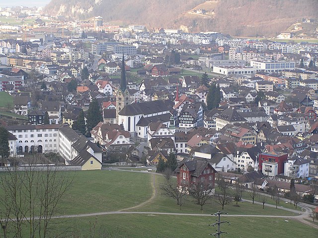

Stans
- municipality in, and capital of, the Swiss canton of Nidwalden
Hiking in Stans
Hiking in Stans, a picturesque town in the Lucerne region of Switzerland, offers a variety of trails that cater to different skill levels and preferences. The stunning backdrop of the Swiss Alps provides a breathtaking experience, making it a popular destination for outdoor enthusiasts. Here are some key points to consider when hiking in Stans:...
- Country:
- Postal Code: 6370
- Local Dialing Code: 041
- Licence Plate Code: NW
- Coordinates: 46° 57' 34" N, 8° 22' 0" E
- GPS tracks (wikiloc): [Link]
- AboveSeaLevel: 452 м m
- Area: 11.08 sq km
- Population: 8411
- Web site: [Link]


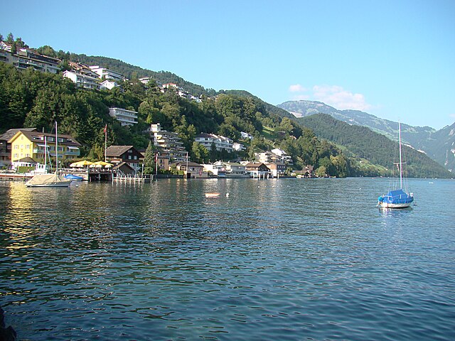
Stansstad
- municipality in Switzerland
Hiking in Stansstad
Stansstad, located in the canton of Nidwalden in Switzerland, offers a variety of stunning hiking opportunities. Nestled between Lake Lucerne and the surrounding mountains, it's an ideal destination for both casual walkers and experienced hikers....
- Country:
- Postal Code: 6362
- Local Dialing Code: 041
- Licence Plate Code: NW
- Coordinates: 46° 58' 49" N, 8° 20' 20" E
- GPS tracks (wikiloc): [Link]
- AboveSeaLevel: 436 м m
- Area: 17.11 sq km
- Population: 4494
- Web site: [Link]

Ennetbürgen
- municipality in Switzerland
Hiking in Ennetbürgen
Ennetbürgen is a picturesque village located near Lake Lucerne in the canton of Nidwalden, Switzerland. It offers a variety of hiking opportunities that immerse you in breathtaking natural landscapes, including stunning lake views and mountainous terrain. Here are some highlights and tips for hiking in and around Ennetbürgen:...
- Country:
- Postal Code: 6373
- Local Dialing Code: 041
- Licence Plate Code: NW
- Coordinates: 46° 59' 4" N, 8° 24' 50" E
- GPS tracks (wikiloc): [Link]
- AboveSeaLevel: 435 м m
- Area: 17.70 sq km
- Population: 4698
- Web site: [Link]


Wolfenschiessen
- municipality in Switzerland
Hiking in Wolfenschiessen
Wolfenschiessen is a charming village located in the Nidwalden region of Switzerland, nestled between the well-known mountains of the area. It's an excellent base for hiking enthusiasts due to its stunning natural scenery, well-marked trails, and access to the surrounding alpine landscapes....
- Country:
- Postal Code: 6386
- Local Dialing Code: 041
- Licence Plate Code: NW
- Coordinates: 46° 51' 46" N, 8° 23' 40" E
- GPS tracks (wikiloc): [Link]
- AboveSeaLevel: 1516 м m
- Area: 92.76 sq km
- Population: 2093
- Web site: [Link]


Buochs
- municipality in Switzerland
Hiking in Buochs
Buochs is a charming municipality located in the canton of Nidwalden in Switzerland, nestled at the northern end of Lake Lucerne. The area offers stunning natural beauty and a variety of hiking opportunities suitable for different skill levels. Here are some highlights and tips for hiking in and around Buochs:...
- Country:
- Postal Code: 6374
- Local Dialing Code: 041
- Licence Plate Code: NW
- Coordinates: 46° 58' 29" N, 8° 25' 14" E
- GPS tracks (wikiloc): [Link]
- AboveSeaLevel: 436 м m
- Area: 12.04 sq km
- Population: 5409
- Web site: [Link]


Dallenwil
- municipality in Switzerland
Hiking in Dallenwil
Dallenwil, a charming village located in the canton of Nidwalden, Switzerland, is surrounded by stunning natural landscapes that offer a variety of hiking opportunities. The area is known for its picturesque trails that cater to different skill levels, making it an attractive destination for both beginner and experienced hikers....
- Country:
- Postal Code: 6383
- Local Dialing Code: 041
- Licence Plate Code: NW
- Coordinates: 46° 55' 3" N, 8° 21' 54" E
- GPS tracks (wikiloc): [Link]
- AboveSeaLevel: 1072 м m
- Area: 15.48 sq km
- Population: 1814
- Web site: [Link]


Ennetmoos
- municipality in Switzerland
Hiking in Ennetmoos
Ennetmoos is a charming village located near Lake Lucerne in Switzerland's scenic region. It is an excellent destination for hiking enthusiasts, offering a variety of trails that cater to different skill levels and preferences. Here are some highlights for hiking in Ennetmoos:...
- Country:
- Postal Code: 6372
- Local Dialing Code: 041
- Licence Plate Code: NW
- Coordinates: 46° 57' 24" N, 8° 20' 14" E
- GPS tracks (wikiloc): [Link]
- AboveSeaLevel: 521 м m
- Area: 14.95 sq km
- Population: 2147
- Web site: [Link]


Oberdorf
- municipality in the canton of Nidwalden, Switzerland
Hiking in Oberdorf
Oberdorf, located in the Nidwalden canton of Switzerland, offers a beautiful setting for hiking enthusiasts. Nestled in the central part of the country, this region is known for its stunning landscapes, including rolling hills, lush forests, and picturesque views of the surrounding mountains....
- Country:
- Postal Code: 6370
- Local Dialing Code: 041
- Licence Plate Code: NW
- Coordinates: 46° 56' 33" N, 8° 24' 21" E
- GPS tracks (wikiloc): [Link]
- AboveSeaLevel: 716 м m
- Area: 16.20 sq km
- Population: 3133
- Web site: [Link]


Beckenried
- municipality in Switzerland
Hiking in Beckenried
Beckenried, located in the canton of Nidwalden, Switzerland, is a beautiful destination for hiking enthusiasts. Nestled between Lake Lucerne and the surrounding mountains, it offers a variety of trails with stunning views, diverse landscapes, and the opportunity to explore the natural beauty of the region....
- Country:
- Postal Code: 6375
- Local Dialing Code: 041
- Licence Plate Code: NW
- Coordinates: 46° 57' 59" N, 8° 28' 29" E
- GPS tracks (wikiloc): [Link]
- AboveSeaLevel: 448 м m
- Area: 32.95 sq km
- Population: 3654
- Web site: [Link]

Emmetten
- municipality in Switzerland
Hiking in Emmetten
Emmetten is a charming village located in Switzerland, offering stunning views of Lake Lucerne and the surrounding mountains, making it an excellent destination for hiking enthusiasts. Here are some key points to consider when planning a hike in Emmetten:...
- Country:
- Postal Code: 6376
- Local Dialing Code: 041
- Licence Plate Code: NW
- Coordinates: 46° 57' 24" N, 8° 31' 5" E
- GPS tracks (wikiloc): [Link]
- AboveSeaLevel: 774 м m
- Area: 28.63 sq km
- Population: 1401
- Web site: [Link]
Shares border with regions:

canton of Bern
- canton of Switzerland
Hiking in canton of Bern
The Canton of Bern, located in Switzerland, offers some of the most stunning landscapes and diverse trails for hiking enthusiasts. This region boasts a mix of alpine scenery, picturesque villages, and lush valleys, making it an excellent destination for all levels of hikers. Here are some highlights you can expect when hiking in the Canton of Bern:...
- Country:
- Capital: Bern
- Licence Plate Code: BE
- Coordinates: 46° 50' 0" N, 7° 37' 0" E
- GPS tracks (wikiloc): [Link]
- AboveSeaLevel: 542 м m
- Area: 5959 sq km
- Population: 1031126
- Web site: [Link]

Canton of Lucerne
- canton of Switzerland
Hiking in Canton of Lucerne
Hiking in the Canton of Lucerne, located in central Switzerland, offers a diverse range of trails that showcase stunning landscapes, picturesque lakes, and the majestic Alps. Here are some highlights and tips for hiking in this beautiful region:...
- Country:
- Capital: Lucerne
- Licence Plate Code: LU
- Coordinates: 47° 5' 0" N, 8° 7' 0" E
- GPS tracks (wikiloc): [Link]
- AboveSeaLevel: 436 м m
- Area: 1493.51 sq km
- Web site: [Link]


Uri
- canton of Switzerland
Hiking in Uri
The Canton of Uri, situated in central Switzerland, offers stunning landscapes and a range of hiking opportunities for all skill levels. Here’s a general overview of hiking in this picturesque region:...
- Country:
- Capital: Altdorf
- Licence Plate Code: UR
- Coordinates: 46° 47' 0" N, 8° 37' 0" E
- GPS tracks (wikiloc): [Link]
- AboveSeaLevel: 447 м m
- Area: 1076.57 sq km
- Population: 36145
- Web site: [Link]

Schwyz
- canton of Switzerland
Hiking in Schwyz
Hiking in the Canton of Schwyz in Switzerland offers a fantastic blend of stunning landscapes, rich cultural history, and well-maintained trails. The region features a variety of terrains, including mountains, lakes, and picturesque villages, making it a great destination for both novice and experienced hikers....
- Country:
- Capital: Schwyz
- Licence Plate Code: SZ
- Coordinates: 47° 4' 0" N, 8° 45' 0" E
- GPS tracks (wikiloc): [Link]
- AboveSeaLevel: 516 м m
- Area: 907.88 sq km
- Population: 155863
- Web site: [Link]

Obwalden
- canton of Switzerland
Hiking in Obwalden
The Canton of Obwalden, located in central Switzerland, is a spectacular area for hiking, characterized by its stunning Alpine landscapes, lush green valleys, and clear lakes. Here are some key highlights and tips for hiking in this beautiful canton:...
- Country:
- Capital: Sarnen
- Licence Plate Code: OW
- Coordinates: 46° 52' 0" N, 8° 2' 0" E
- GPS tracks (wikiloc): [Link]
- AboveSeaLevel: 473 м m
- Area: 490.58 sq km
- Population: 37378
- Web site: [Link]