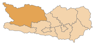
Hermagor District (Bezirk Hermagor)

- district of Austria
 Hiking in Hermagor District
Hermagor District, located in the Austrian state of Carinthia, is a stunning area characterized by its picturesque landscapes, including mountains, lakes, and forests. It's a fantastic destination for hiking enthusiasts, offering a variety of trails suitable for different skill levels.
Key Highlights for Hiking in Hermagor District:
-
Beautiful Scenery:
- The district is home to the stunning Carnic Alps and the Gailtal Alps, providing breathtaking views and diverse ecosystems.
- Plan your hikes to enjoy the crystal-clear waters of the many lakes in the area, such as Lake Pressegger, which is popular for relaxation after a hike.
-
Variety of Trails:
- The region features numerous well-marked hiking trails. Whether you're looking for gentle valley walks or challenging alpine hikes, you'll find options suited to your preferences.
- Popular hikes include the trails around the Nassfeld ski area, which is also a summer hiking paradise.
-
Wildlife and Flora:
- The area is rich in biodiversity. As you hike, you may encounter various wildlife species and a range of beautiful alpine flowers, particularly in spring and early summer.
-
Cultural Experiences:
- Along the hiking routes, you can explore charming villages and historical sites, enriching your outdoor experience with cultural insights.
- Local cuisine is also a highlight; don't miss opportunities to try regional dishes at mountain huts and restaurants.
-
Seasonal Considerations:
- While summer is the prime season for hiking, autumn offers stunning foliage, and winter hiking (with proper gear) is also possible.
- Always check local weather conditions and trail accessibility, especially if hiking in higher altitudes where snow can linger.
-
Safety Tips:
- Ensure you have adequate hiking gear, maps, and knowledge of the trails you choose.
- Inform someone of your hiking plans and expected return time, especially if you're heading into more remote areas.
-
Guided Tours:
- If you're not familiar with the area or prefer a guided experience, there are local hiking guides available who can offer valuable insights and enhance your adventure.
Conclusion
The Hermagor District is a hidden gem for hikers looking for breathtaking natural beauty combined with outdoor adventure. With a well-planned itinerary, you can enjoy the wonders of the Carinthian landscape and make lasting memories on the trails. Remember to respect nature and leave no trace to preserve this beautiful area for future visitors!
- Country:

- Licence Plate Code: HE
- Coordinates: 46° 39' 43" N, 13° 10' 59" E


- GPS tracks (wikiloc): [Link]
- AboveSeaLevel: 794 м m
- Area: 808.02 sq km
- Population: 19294
- Web site: http://www.bh-hermagor.at/
- Wikipedia en: wiki(en)
- Wikipedia: wiki(de)
- Wikidata storage: Wikidata: Q613991
- Wikipedia Commons Category: [Link]
- Freebase ID: [/m/06wk13]
- GeoNames ID: Alt: [2776496]
- VIAF ID: Alt: [125609257]
- GND ID: Alt: [4024502-0]
- archINFORM location ID: [14649]
- Quora topic ID: [Hermagor]
Includes regions:

Sankt Stefan im Gailtal
- municipality in Austria
Hiking in Sankt Stefan im Gailtal
Sankt Stefan im Gailtal, located in the picturesque Gail Valley in Austria, is a fantastic destination for hiking enthusiasts. The region offers diverse landscapes, from lush valleys to stunning mountain views, making it suitable for hikers of all levels. Here are some highlights and tips for hiking in this area:...
- Country:
- Postal Code: 9623
- Local Dialing Code: 0 42 83
- Licence Plate Code: HE
- Coordinates: 46° 37' 0" N, 13° 31' 0" E
- GPS tracks (wikiloc): [Link]
- AboveSeaLevel: 726 м m
- Area: 66.33 sq km
- Population: 1593
- Web site: [Link]
Dellach
- municipality in Austria
Hiking in Dellach
Dellach, situated in the picturesque region of Carinthia in Austria, offers a variety of hiking opportunities amid stunning landscapes. The area is known for its stunning alpine scenery, lush valleys, and tranquil lakes, making it a great destination for nature enthusiasts and hikers of all levels. Here are some key points to consider when hiking in Dellach:...
- Country:
- Postal Code: 9635
- Local Dialing Code: 0 47 18
- Licence Plate Code: HE
- Coordinates: 46° 39' 41" N, 13° 4' 46" E
- GPS tracks (wikiloc): [Link]
- AboveSeaLevel: 672 м m
- Area: 36.17 sq km
- Population: 1231
- Web site: [Link]
Kirchbach
- municipality in Austria
Hiking in Kirchbach
Kirchbach, located in the Carinthia region of Austria, offers a variety of hiking opportunities set against the stunning backdrop of the Julian Alps and lush meadows. Here are some highlights of hiking in this beautiful area:...
- Country:
- Postal Code: 9632
- Local Dialing Code: 04284
- Licence Plate Code: HE
- Coordinates: 46° 38' 28" N, 13° 11' 0" E
- GPS tracks (wikiloc): [Link]
- AboveSeaLevel: 640 м m
- Area: 99.03 sq km
- Population: 2599
- Web site: [Link]

Kötschach-Mauthen
- municipality in Austria
Hiking in Kötschach-Mauthen
Kötschach-Mauthen, located in the picturesque area of Carinthia, Austria, offers a range of hiking opportunities that cater to all levels of experience, from easy walks to more challenging mountain hikes. The scenic landscapes include lush valleys, alpine meadows, and stunning mountain views that make it a delight for nature enthusiasts and hikers alike....
- Country:
- Postal Code: 9640
- Local Dialing Code: 04715
- Licence Plate Code: HE
- Coordinates: 46° 40' 0" N, 13° 0' 0" E
- GPS tracks (wikiloc): [Link]
- AboveSeaLevel: 705 м m
- Area: 154.14 sq km
- Population: 3348
- Web site: [Link]


Hermagor-Pressegger See
- municipality in Austria
Hiking in Hermagor-Pressegger See
Hermagor-Pressegger See, located in the Carinthia region of Austria, is a beautiful area known for its stunning natural landscapes, making it a great destination for hiking enthusiasts. Here are some key points to consider when planning a hike in this region:...
- Country:
- Postal Code: 9620
- Local Dialing Code: 04282
- Licence Plate Code: HE
- Coordinates: 46° 37' 38" N, 13° 22' 2" E
- GPS tracks (wikiloc): [Link]
- AboveSeaLevel: 602 м m
- Area: 204.84 sq km
- Population: 6824
- Web site: [Link]

Lesachtal
- municipality in Austria
Hiking in Lesachtal
Lesachtal is a picturesque valley located in the Austrian Alps, primarily in Carinthia, and is known for its stunning natural landscapes, traditional villages, and a variety of hiking trails suited for different skill levels. Here’s what you can expect when hiking in Lesachtal:...
- Country:
- Local Dialing Code: 04716
- Licence Plate Code: HE
- Coordinates: 46° 41' 38" N, 12° 48' 57" E
- GPS tracks (wikiloc): [Link]
- AboveSeaLevel: 1043 м m
- Area: 190.69 sq km
- Population: 1318
- Web site: [Link]

Gitschtal
- municipality in Austria
Hiking in Gitschtal
Gitschtal is a picturesque valley located in Carinthia, Austria, known for its stunning natural beauty and diverse hiking opportunities. The area offers various trails suited for different skill levels, from leisurely walks to more challenging hikes....
- Country:
- Postal Code: 9622
- Local Dialing Code: 0 42 86
- Licence Plate Code: HE
- Coordinates: 46° 40' 47" N, 13° 15' 38" E
- GPS tracks (wikiloc): [Link]
- AboveSeaLevel: 817 м m
- Area: 56.47 sq km
- Population: 1261
- Web site: [Link]
Shares border with regions:

Spittal an der Drau District
- administrative district in Carinthia, Austria
Hiking in Spittal an der Drau District
Spittal an der Drau District, located in the Carinthia region of Austria, is a stunning destination for hiking enthusiasts. Surrounded by the dramatic landscapes of the Alps and lush valleys, this area offers a diverse range of hiking trails suitable for various skill levels, from gentle walks to challenging mountain hikes....
- Country:
- Licence Plate Code: SP
- Coordinates: 46° 49' 59" N, 13° 18' 22" E
- GPS tracks (wikiloc): [Link]
- AboveSeaLevel: 922 м m
- Area: 2764 sq km
- Population: 76248
- Web site: [Link]