
Carinthia (Kärnten)


- state of Austria
 Hiking in Carinthia
Carinthia, located in the southern part of Austria, is a fantastic destination for hiking enthusiasts. The region is known for its stunning landscapes, which include majestic mountains, deep valleys, pristine lakes, and lush forests. Here are some highlights and tips for hiking in Carinthia:
Key Regions and Trails
-
Nockberge National Park: This park features gentle hills and diverse flora and fauna. Trails like the "Nockalm Road" or a trek to the "Mount Goldeck" offer beautiful views and well-marked paths.
-
Hohe Tauern National Park: This is the largest national park in Austria and offers a variety of hiking routes that range from easy walks to challenging high-altitude hikes. The path to "Großglockner," Austria's highest mountain, is particularly popular.
-
Lake District (Kärntner Seen): The region is dotted with numerous lakes, such as Lake Wörthersee, Lake Millstatt, and Lake Ossiach. Many hiking trails circle these lakes, providing scenic views and opportunities for swimming.
-
Drau Valley: The Drau Cycle Path follows the river but also connects to various hiking trails that lead through picturesque villages and vineyards.
Hiking Conditions
-
Seasons: The best time for hiking in Carinthia is spring through autumn. Summer can be warm, but higher altitudes provide cooler conditions. Winter sports are also popular, with opportunities for snowshoeing and winter hiking.
-
Weather: Always check the local weather forecast before heading out. Conditions can change rapidly in the mountains.
Preparation Tips
-
Maps & Apps: Utilize detailed hiking maps or mobile apps to navigate trails. Many routes are well-marked, but it's good to have a backup plan.
-
Gear: Ensure you wear appropriate hiking boots, carry enough water, and bring snacks. A first-aid kit and a weather-appropriate jacket are also recommended.
-
Respect Nature: Stay on marked trails to protect local flora and fauna and carry out whatever you bring in.
Local Culture
Immerse yourself in Carinthia’s local culture by trying regional cuisine and exploring the charming villages along your routes. Traditional dishes often feature fresh ingredients from the surrounding countryside.
Conclusion
Carinthia offers an excellent mix of outdoor adventure, stunning scenery, and cultural experiences. Whether you're a seasoned hiker or a beginner, the region has trails suitable for all skill levels. Make sure to do some research and plan your hikes according to your ability and interests! Happy hiking!
- Country:

- Capital: Klagenfurt
- Coordinates: 46° 45' 40" N, 13° 49' 8" E


- GPS tracks (wikiloc): [Link]
- AboveSeaLevel: 1449 м m
- Area: 9535.97 sq km
- Population: 560300
- Web site: http://www.ktn.gv.at
- Wikipedia en: wiki(en)
- Wikipedia: wiki(de)
- Wikidata storage: Wikidata: Q37985
- Wikipedia Commons Gallery: [Link]
- Wikipedia Commons Category: [Link]
- Wikipedia Commons Maps Category: [Link]
- Freebase ID: [/m/01gpy4]
- GeoNames ID: Alt: [2774686]
- BnF ID: [11931117q]
- VIAF ID: Alt: [130825241]
- GND ID: Alt: [4029175-3]
- archINFORM location ID: [2814]
- MusicBrainz area ID: [837417a1-e3fe-412a-a525-2622fd5aafa6]
- Quora topic ID: [Carinthia]
- TGN ID: [7003024]
- Encyclopædia Britannica Online ID: [place/Karnten]
- Encyclopædia Universalis ID: [carinthie]
- ISNI: Alt: [0000 0004 0393 5995]
- NKCR AUT ID: [ge134282]
- DMOZ ID: Alt: [Regional/Europe/Austria/Provinces/Carinthia/]
- NUTS code: [AT21]
- YSO ID: [113092]
- Klexikon article ID: [Kärnten]
- STW Thesaurus for Economics ID: [16946-2]
- Catholic Encyclopedia ID: [08606a]
- ISO 3166-2 code: AT-2
- FIPS 10-4 (countries and regions): AU02
Includes regions:


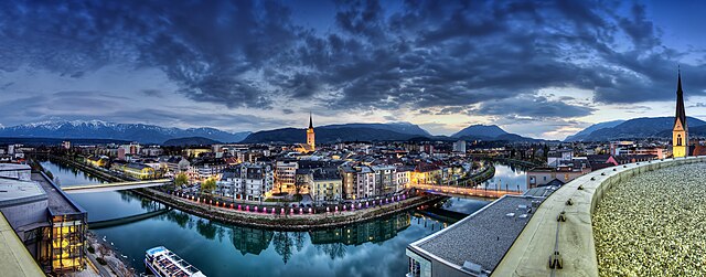
Klagenfurt
- city in Austria
Hiking in Klagenfurt
Klagenfurt, located in Austria's Carinthia region, offers a stunning backdrop for hiking enthusiasts. Nestled near the eastern shore of Lake Wörthersee and surrounded by scenic mountain ranges, it boasts a variety of hiking trails suitable for different experience levels....
- Country:
- Postal Code: 9201; 9073; 9065; 9063; 9061; 9020
- Local Dialing Code: 0463
- Licence Plate Code: K
- Coordinates: 46° 37' 0" N, 14° 18' 0" E
- GPS tracks (wikiloc): [Link]
- AboveSeaLevel: 446 м m
- Area: 120 sq km
- Population: 100369
- Web site: [Link]
Villach
- city in Austria
Hiking in Villach
Villach, located in Austria's Carinthia region, is an excellent destination for hiking enthusiasts. Nestled between the Drau River and the peaks of the Alps, this charming town offers a variety of hiking trails suitable for different skill levels, as well as stunning landscapes to explore....
- Country:
- Postal Code: 9500
- Local Dialing Code: 04242
- Licence Plate Code: VI
- Coordinates: 46° 37' 0" N, 13° 50' 0" E
- GPS tracks (wikiloc): [Link]
- AboveSeaLevel: 501 м m
- Area: 135 sq km
- Population: 61879
- Web site: [Link]

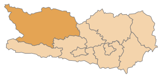
Hermagor District
- district of Austria
Hiking in Hermagor District
Hermagor District, located in the Austrian state of Carinthia, is a stunning area characterized by its picturesque landscapes, including mountains, lakes, and forests. It's a fantastic destination for hiking enthusiasts, offering a variety of trails suitable for different skill levels....
- Country:
- Licence Plate Code: HE
- Coordinates: 46° 39' 43" N, 13° 10' 59" E
- GPS tracks (wikiloc): [Link]
- AboveSeaLevel: 794 м m
- Area: 808.02 sq km
- Population: 19294
- Web site: [Link]


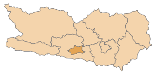
Sankt Veit an der Glan District
- district of Austria
Hiking in Sankt Veit an der Glan District
Sankt Veit an der Glan District, located in the state of Carinthia, Austria, offers an array of beautiful hiking opportunities. This region is characterized by its stunning landscapes, including rolling hills, forests, and picturesque lakes, making it ideal for outdoor enthusiasts....
- Country:
- Licence Plate Code: SV
- Coordinates: 46° 51' 43" N, 14° 25' 41" E
- GPS tracks (wikiloc): [Link]
- AboveSeaLevel: 675 м m
- Area: 1493.67 sq km
- Web site: [Link]


Villach-Land District
- district of Austria
Hiking in Villach-Land District
Villach-Land District, located in the southern part of Austria, is a fantastic area for hiking enthusiasts. It is surrounded by stunning natural landscapes, including the Alps, Lake Ossiach, and several picturesque valleys. The diverse terrain offers a wide range of hiking trails suitable for all skill levels, from gentle walks to more challenging mountain hikes....
- Country:
- Licence Plate Code: VL
- Coordinates: 46° 37' 26" N, 13° 43' 26" E
- GPS tracks (wikiloc): [Link]
- AboveSeaLevel: 535 м m
- Area: 1009.33 sq km
- Population: 64698
- Web site: [Link]

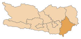
Völkermarkt District
- district in Austria
Hiking in Völkermarkt District
Völkermarkt District, located in the southern part of Austria, offers a variety of hiking opportunities set against a backdrop of stunning natural landscapes. The district is characterized by its diverse terrain, including mountains, forests, and lakes, making it an appealing destination for both casual hikers and seasoned adventurers....
- Country:
- Capital: Völkermarkt
- Licence Plate Code: VK
- Coordinates: 46° 35' 28" N, 14° 38' 38" E
- GPS tracks (wikiloc): [Link]
- AboveSeaLevel: 473 м m
- Area: 907.49 sq km
- Web site: [Link]

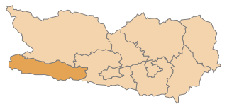
Spittal an der Drau District
- administrative district in Carinthia, Austria
Hiking in Spittal an der Drau District
Spittal an der Drau District, located in the Carinthia region of Austria, is a stunning destination for hiking enthusiasts. Surrounded by the dramatic landscapes of the Alps and lush valleys, this area offers a diverse range of hiking trails suitable for various skill levels, from gentle walks to challenging mountain hikes....
- Country:
- Licence Plate Code: SP
- Coordinates: 46° 49' 59" N, 13° 18' 22" E
- GPS tracks (wikiloc): [Link]
- AboveSeaLevel: 922 м m
- Area: 2764 sq km
- Population: 76248
- Web site: [Link]

Klagenfurt-Land District
- district of Austria
Hiking in Klagenfurt-Land District
Klagenfurt-Land District, located in the Carinthia region of Austria, offers a wonderful opportunity for hiking enthusiasts. The district is characterized by its stunning landscapes, including rolling hills, lush forests, and numerous lakes. Here are some highlights and tips for hiking in the area:...
- Country:
- Licence Plate Code: KL
- Coordinates: 46° 36' 32" N, 14° 14' 2" E
- GPS tracks (wikiloc): [Link]
- AboveSeaLevel: 564 м m
- Web site: [Link]

Wolfsberg District
- district of Austria
Hiking in Wolfsberg District
Wolfsberg District, located in the Carinthia region of Austria, is known for its stunning landscapes, rich cultural history, and extensive hiking opportunities. Here are some highlights for hiking in the area:...
- Country:
- Capital: Wolfsberg
- Licence Plate Code: WO
- Coordinates: 46° 50' 31" N, 14° 51' 36" E
- GPS tracks (wikiloc): [Link]
- AboveSeaLevel: 455 м m
- Web site: [Link]

Feldkirchen District
- district of Austria
Hiking in Feldkirchen District
Feldkirchen District, located in the state of Carinthia in Austria, is a beautiful area for hiking enthusiasts. The district features a diverse landscape with rolling hills, lush forests, and scenic lakes, ideal for various skill levels of hikers. Here are some key highlights and popular trails in the Feldkirchen District:...
- Country:
- Licence Plate Code: FE
- Coordinates: 46° 45' 0" N, 14° 2' 13" E
- GPS tracks (wikiloc): [Link]
- AboveSeaLevel: 544 м m
- Web site: [Link]
Shares border with regions:
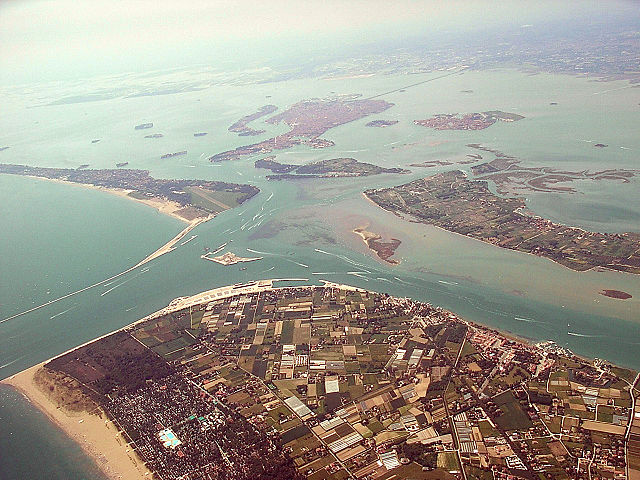
Veneto
- region in Italy
Hiking in Veneto
Hiking in the Veneto region of Italy offers a diverse range of landscapes and experiences, from the idyllic foothills of the Alps to the scenic paths along the Adriatic coast. Here are some highlights and notable trails to consider:...
- Country:

- Capital: Venice
- Coordinates: 45° 44' 0" N, 11° 51' 0" E
- GPS tracks (wikiloc): [Link]
- AboveSeaLevel: 180 м m
- Area: 18339 sq km
- Population: 4925737
- Web site: [Link]

Friuli–Venezia Giulia
- region of Italy
Hiking in Friuli–Venezia Giulia
Friuli-Venezia Giulia is a stunning region in northeastern Italy, known for its diverse landscapes ranging from the Adriatic Sea to the foothills of the Alps. This region offers a variety of hiking opportunities suitable for all levels of hikers, making it a fantastic destination for enthusiasts of the outdoors. Here are some highlights:...
- Country:
- Capital: Trieste
- Coordinates: 46° 6' 0" N, 13° 7' 0" E
- GPS tracks (wikiloc): [Link]
- AboveSeaLevel: 206 м m
- Area: 7862.3 sq km
- Population: 1222438
- Web site: [Link]

Province of Belluno
- one of seven provinces in the Italian region Veneto
Hiking in Province of Belluno
The Province of Belluno, located in the Veneto region of northern Italy, is a spectacular destination for hiking enthusiasts. This province is predominantly covered by the Dolomites, a UNESCO World Heritage site known for its stunning landscapes, unique geological formations, and rich biodiversity. Here are some key points about hiking in the Province of Belluno:...
- Country:
- Capital: Belluno
- Postal Code: 32010–32047; 32100
- Local Dialing Code: 0437; 0439; 0436; 0435
- Licence Plate Code: BL
- Coordinates: 46° 8' 27" N, 12° 12' 56" E
- GPS tracks (wikiloc): [Link]
- Area: 3677 sq km
- Population: 209550
- Web site: [Link]
Province of Udine
- province of Italy
Hiking in Province of Udine
The Province of Udine, located in the Friuli Venezia Giulia region of northeastern Italy, offers a rich variety of landscapes perfect for hiking enthusiasts. From the foothills of the Julian Alps to the picturesque landscapes of the Collio wine region, this area is filled with trails suitable for all skill levels....
- Country:
- Capital: Udine
- Postal Code: 33015–33059; 33013; 33010–33011; 33100
- Local Dialing Code: 0427; 0433; 0432; 0431; 0428
- Licence Plate Code: UD
- Coordinates: 46° 4' 0" N, 13° 14' 0" E
- GPS tracks (wikiloc): [Link]
- Area: 4905 sq km
- Population: 528441
- Web site: [Link]


Styria
- federated state in Austria
Hiking in Styria
Styria, a beautiful region in Austria, is a fantastic destination for hiking enthusiasts. Known for its diverse landscapes, lush forests, rolling hills, and stunning alpine views, Styria offers a variety of trails suitable for all experience levels. Here’s what you can expect when hiking in Styria:...
- Country:
- Capital: Graz
- Coordinates: 47° 15' 0" N, 15° 10' 0" E
- GPS tracks (wikiloc): [Link]
- AboveSeaLevel: 2995 м m
- Area: 16400.75 sq km
- Population: 1231865
- Web site: [Link]


Tyrol
- federal state in western Austria
Hiking in Tyrol
Tyrol, located in the Austrian Alps, is a paradise for hiking enthusiasts, offering a diverse array of trails that cater to all skill levels. The landscape is characterized by stunning mountain vistas, lush valleys, sparkling lakes, and charming alpine villages, making it a perfect setting for outdoor activities....
- Country:
- Capital: Innsbruck
- Coordinates: 47° 16' 0" N, 11° 24' 0" E
- GPS tracks (wikiloc): [Link]
- AboveSeaLevel: 605 м m
- Area: 12647.71 sq km
- Population: 739002
- Web site: [Link]


Salzburg
- state of Austria
Hiking in Salzburg
Salzburg, located in Austria, is renowned for its stunning alpine landscapes and rich cultural heritage, making it a fantastic destination for hiking enthusiasts. Here are some highlights and tips for hiking in the state of Salzburg:...
- Country:
- Capital: Salzburg
- Coordinates: 47° 46' 1" N, 13° 21' 51" E
- GPS tracks (wikiloc): [Link]
- AboveSeaLevel: 827 м m
- Area: 7156.03 sq km
- Population: 545742
- Web site: [Link]