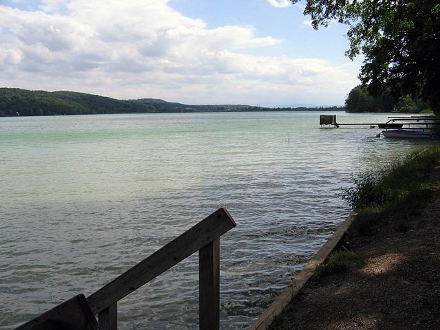
Herrsching am Ammersee (Herrsching am Ammersee)

- municipality of Germany
 Hiking in Herrsching am Ammersee
Herrsching is a charming town located on the western shore of Lake Ammersee in Bavaria, Germany. It is an excellent destination for hiking enthusiasts due to its stunning natural landscapes, scenic views, and well-marked trails. Here are some key highlights and tips for hiking in Herrsching:
Trails and Routes
-
Ammersee Loop Trail:
- This is a popular circular route that encircles Lake Ammersee. The trail offers breathtaking views of the lake, along with picturesque meadows and forests. The entire loop is around 20 kilometers (12 miles) long, making it perfect for a day hike.
-
Buchenberg Trail:
- The hike to Buchenberg is a shorter, family-friendly trail that leads to a lookout point with panoramic views over Lake Ammersee and the surrounding countryside. It is suitable for hikers of all skill levels.
-
König Ludwig Trail:
- Although a bit farther from Herrsching, this trail is significant as it connects several landmarks associated with King Ludwig II. It offers a stunning experience for those wanting to explore the Bavarian countryside.
Scenic Features
- The region around Herrsching offers a variety of landscapes, including forests, rolling hills, and beautiful lakeside views. The changing seasons provide different experiences — from lush greenery in summer to vibrant autumn colors.
Tips for Hiking in Herrsching
-
Prepare Accordingly:
- Make sure to wear appropriate footwear with good grip, and dress in layers to accommodate changing weather conditions.
-
Check Trail Conditions:
- Before heading out, check local information for trail conditions or closures, especially after heavy rain or during winter.
-
Stay Hydrated:
- Bring enough water, especially on longer hikes, and consider packing some snacks for energy.
-
Respect Nature:
- Follow the Leave No Trace principles: stay on marked paths, collect your trash, and respect wildlife.
-
Public Transport Accessibility:
- Herrsching is easily accessible by train from Munich, making it an ideal destination for day hikes. You can also find accommodations if you wish to stay longer and explore more trails.
-
Consider a Local Guide:
- If you're new to hiking or the region, consider joining a local hiking group or hiring a guide to enhance your experience.
Herrsching offers a delightful combination of outdoor activity, stunning scenery, and cultural experiences. Whether you’re a seasoned hiker or a beginner, there are plenty of trails to explore and enjoy in this beautiful region of Bavaria.
- Country:

- Postal Code: 82211
- Local Dialing Code: 08152
- Licence Plate Code: STA
- Coordinates: 47° 59' 56" N, 11° 10' 36" E


- GPS tracks (wikiloc): [Link]
- AboveSeaLevel: 551 м m
- Area: 20.88 sq km
- Population: 10400
- Web site: https://www.herrsching.de/
- Wikipedia en: wiki(en)
- Wikipedia: wiki(de)
- Wikidata storage: Wikidata: Q170020
- Wikipedia Commons Category: [Link]
- Freebase ID: [/m/06snck]
- GeoNames ID: Alt: [2905604]
- VIAF ID: Alt: [128487922]
- OSM relation ID: [932292]
- GND ID: Alt: [4135707-3]
- archINFORM location ID: [12109]
- Library of Congress authority ID: Alt: [n84175154]
- MusicBrainz area ID: [c27de53c-a72a-4298-b2ca-fc00fe1d0a83]
- Quora topic ID: [Herrsching]
- Historical Gazetteer (GOV) ID: [HERSEEJN58OA]
- Facebook Places ID: [112638162087152]
- Bavarikon ID: [ODB_A00001344]
- German municipality key: 09188124
Shares border with regions:

Seefeld
- municipality in Bavaria, Germany
Hiking in Seefeld
Seefeld is actually located in Austria, not Bavaria, but it is very close to the German border and is a popular destination for outdoor activities, including hiking. The region is known for its stunning alpine scenery, well-maintained trails, and a variety of hiking options suitable for all levels....
- Country:
- Postal Code: 82229
- Local Dialing Code: 08152
- Licence Plate Code: STA
- Coordinates: 48° 2' 0" N, 11° 12' 0" E
- GPS tracks (wikiloc): [Link]
- AboveSeaLevel: 570 м m
- Area: 34.87 sq km
- Population: 7039
- Web site: [Link]


Andechs
- city in Germany
Hiking in Andechs
Hiking in Andechs, Germany, offers a delightful experience, especially for those who enjoy beautiful landscapes, historical sites, and local culture. Andechs is situated in the Bavarian region, just south of Munich, and is famously known for its scenic views and the Andechs Monastery, which overlooks the picturesque surroundings....
- Country:
- Postal Code: 82346
- Local Dialing Code: 08152
- Licence Plate Code: STA
- Coordinates: 47° 58' 0" N, 11° 11' 5" E
- GPS tracks (wikiloc): [Link]
- AboveSeaLevel: 690 м m
- Area: 40.44 sq km
- Population: 3527
- Web site: [Link]

Inning am Ammersee
- municipality of Germany
Hiking in Inning am Ammersee
Inning am Ammersee is a picturesque town located on the shores of Lake Ammersee in Bavaria, Germany. It offers a variety of hiking opportunities, making it an appealing destination for outdoor enthusiasts. Here are some highlights when it comes to hiking in this area:...
- Country:
- Postal Code: 82266
- Local Dialing Code: 08143
- Licence Plate Code: STA
- Coordinates: 48° 4' 35" N, 11° 9' 8" E
- GPS tracks (wikiloc): [Link]
- AboveSeaLevel: 553 м m
- Area: 24.43 sq km
- Population: 3191
- Web site: [Link]