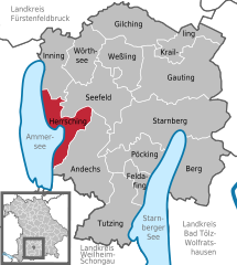
Seefeld (Seefeld)
- municipality in Bavaria, Germany
Seefeld is actually located in Austria, not Bavaria, but it is very close to the German border and is a popular destination for outdoor activities, including hiking. The region is known for its stunning alpine scenery, well-maintained trails, and a variety of hiking options suitable for all levels.
Hiking in Seefeld:
Trail Diversity:
- Easy Trails: There are several easy walking paths suitable for families and beginner hikers. These often take you through lush meadows and offer gentle climbs.
- Moderate Trails: For those looking for a bit more challenge, there are moderate trails that feature steeper ascents and varied terrain.
- Difficult Trails: Experienced hikers can tackle more demanding routes that lead to higher altitudes and potentially offer panoramic views of the surrounding mountains.
Scenic Highlights:
- Wildsee Lake: A beautiful spot where you can enjoy a relaxing hike around the lake and take in the stunning reflections of the mountains in the water.
- Karwendel Nature Park: Just a short distance away, this park offers a variety of trails that highlight the area's rich biodiversity and stunning landscapes.
- Views of the Tyrolean Alps: Many trails afford breathtaking views of the Alps, making for fantastic photo opportunities.
Seasonal Considerations:
- Summer Hiking: In the summer months, the region is lush and green, with wildflowers blooming along the trails.
- Winter Hiking: In winter, some trails are maintained for snowshoeing and winter hiking, allowing you to explore the snowy landscape.
Trail Maintenance and Signage:
The trails in and around Seefeld are well-marked with signs indicating trail difficulty, distance, and estimated hiking times, making navigation easier for hikers.
Facilities:
- Huts and Cafés: Along the trails, you’ll often find mountain huts and cafés where you can stop for refreshments and traditional Tyrolean food.
- Accessibility: Seefeld is also known for its good infrastructure, making it easy to reach trailheads and access public transport.
Preparation Tips:
- Footwear: Wear sturdy hiking boots with good ankle support.
- Weather: Check the weather before your hike, and be prepared for sudden changes in mountain weather.
- Hydration & Nutrition: Carry enough water and snacks to keep your energy up.
Whether you’re enjoying a leisurely stroll or tackling more challenging hikes, Seefeld offers a beautiful outdoor experience in the heart of the Alps.
- Country:

- Postal Code: 82229
- Local Dialing Code: 08152
- Licence Plate Code: STA
- Coordinates: 48° 2' 0" N, 11° 12' 0" E


- GPS tracks (wikiloc): [Link]
- AboveSeaLevel: 570 м m
- Area: 34.87 sq km
- Population: 7039
- Web site: http://www.seefeld.de
- Wikipedia en: wiki(en)
- Wikipedia: wiki(de)
- Wikidata storage: Wikidata: Q138356
- Wikipedia Commons Category: [Link]
- Freebase ID: [/m/02q8gnp]
- GeoNames ID: Alt: [6556390]
- VIAF ID: Alt: [139296627]
- OSM relation ID: [932388]
- GND ID: Alt: [4269587-9]
- archINFORM location ID: [8531]
- MusicBrainz area ID: [fe527049-c1f1-41d9-a129-c03f8e26f7d5]
- Facebook Places ID: [104806886222601]
- Bavarikon ID: [ODB_A00001347]
- German municipality key: 09188132
Shares border with regions:


Herrsching am Ammersee
- municipality of Germany
 Hiking in Herrsching am Ammersee
Herrsching is a charming town located on the western shore of Lake Ammersee in Bavaria, Germany. It is an excellent destination for hiking enthusiasts due to its stunning natural landscapes, scenic views, and well-marked trails. Here are some key highlights and tips for hiking in Herrsching:...
- Country:

- Postal Code: 82211
- Local Dialing Code: 08152
- Licence Plate Code: STA
- Coordinates: 47° 59' 56" N, 11° 10' 36" E


- GPS tracks (wikiloc): [Link]
- AboveSeaLevel: 551 м m
- Area: 20.88 sq km
- Population: 10400
- Web site: [Link]


Inning am Ammersee
- municipality of Germany
Inning am Ammersee is a picturesque town located on the shores of Lake Ammersee in Bavaria, Germany. It offers a variety of hiking opportunities, making it an appealing destination for outdoor enthusiasts. Here are some highlights when it comes to hiking in this area:...
- Country:

- Postal Code: 82266
- Local Dialing Code: 08143
- Licence Plate Code: STA
- Coordinates: 48° 4' 35" N, 11° 9' 8" E


- GPS tracks (wikiloc): [Link]
- AboveSeaLevel: 553 м m
- Area: 24.43 sq km
- Population: 3191
- Web site: [Link]
