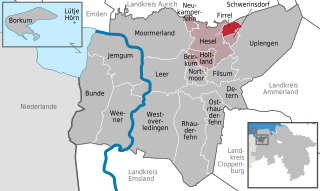
Hesel (Samtgemeinde Hesel)
- Samtgemeinde in Lower Saxony
 Hiking in Hesel
Hesel, located in the Samtgemeinde of Hesel in Lower Saxony, Germany, offers a variety of opportunities for hiking enthusiasts. The region is characterized by its picturesque landscapes, which include wooded areas, farmland, and small rivers. Here are some highlights about hiking in Hesel:
Trails and Routes
-
Local Trails: The area provides several well-marked hiking trails that vary in length and difficulty, making it suitable for both novice and experienced hikers. Look for local signs that guide hikers through scenic paths.
-
Nature Reserves: There are nearby nature reserves that feature rich biodiversity, making them ideal for nature walks. Exploring these reserves can also lead to opportunities for birdwatching and observing local flora.
-
Longer Hikes: For those looking for a longer adventure, you can connect to surrounding trails that lead further into the countryside, offering a chance to explore neighboring towns and the stunning natural surroundings.
Scenic Views
Hiking in Hesel allows you to experience the serene beauty of the Lower Saxony landscape, including rolling hills and expansive fields, which can be particularly beautiful during the spring and summer months.
Practical Information
- Best Time to Hike: Late spring to early autumn is usually the best time for hiking in the region, as weather conditions are generally mild and the scenery is at its most vibrant.
- What to Bring: Make sure to wear sturdy hiking boots, bring plenty of water, snacks, a map or GPS device, and weather-appropriate clothing. It's also wise to check the local weather forecast before heading out.
Local Amenities
Post-hike, you can explore Hesel’s local amenities, including cafes and restaurants that offer regional dishes, giving you a chance to relax and enjoy the local culture after a day of hiking.
Community and Events
Check if there are any local hiking events or guided tours organized by the community. These can be great ways to meet fellow hiking enthusiasts and gain insight into hidden trails and local history.
Whether you’re a casual walker or a dedicated hiker, Hesel offers a delightful escape into nature. Always make sure to follow local guidelines and respect the natural environment during your hikes. Enjoy your adventure!
- Country:

- Coordinates: 53° 18' 0" N, 7° 36' 0" E


- GPS tracks (wikiloc): [Link]
- Population: 10809
- Wikipedia en: wiki(en)
- Wikipedia: wiki(de)
- Wikidata storage: Wikidata: Q121676
- Freebase ID: [/m/02v_wfv]
- VIAF ID: Alt: [247390831]
- GND ID: Alt: [4630286-4]
- German regional key: 034575402
Includes regions:


Neukamperfehn
- municipality of Germany
Hiking in Neukamperfehn
Neukamperfehn, located in Lower Saxony, Germany, is a small village that lies amidst serene landscapes, making it an excellent spot for nature enthusiasts and hikers. While the area might not be as famous as some larger hiking destinations, it offers peaceful trails and the opportunity to experience the beauty of the German countryside....
- Country:
- Postal Code: 26835
- Local Dialing Code: 04946
- Licence Plate Code: LER
- Coordinates: 53° 20' 0" N, 7° 33' 0" E
- GPS tracks (wikiloc): [Link]
- AboveSeaLevel: 1 м m
- Area: 6.27 sq km
- Population: 1710
- Web site: [Link]


Hesel
- municipality of Germany
Hiking in Hesel
Hesel is a small town in Lower Saxony, Germany, known for its picturesque countryside and nearby nature areas. While it may not be as famous as some larger hiking destinations, it offers several opportunities for outdoor enthusiasts to enjoy nature....
- Country:
- Postal Code: 26835
- Local Dialing Code: 04950
- Licence Plate Code: LER
- Coordinates: 53° 18' 0" N, 7° 36' 0" E
- GPS tracks (wikiloc): [Link]
- AboveSeaLevel: 11 м m
- Area: 44.02 sq km
- Population: 4624
- Web site: [Link]
Brinkum
- municipality of Germany
Hiking in Brinkum
Brinkum is a charming area in Germany that offers a variety of outdoor activities, including hiking. While it may not be as rugged as some of Germany's larger hiking regions, it can still provide pleasant walking paths and trails for those looking to enjoy nature....
- Country:
- Postal Code: 26835
- Local Dialing Code: 04950
- Licence Plate Code: LER
- Coordinates: 53° 16' 0" N, 7° 34' 0" E
- GPS tracks (wikiloc): [Link]
- AboveSeaLevel: 8 м m
- Area: 5.51 sq km
- Population: 750
- Web site: [Link]


Holtland
- municipality of Germany
Hiking in Holtland
Holtland, located in Lower Saxony, Germany, is a smaller village known for its picturesque countryside and access to natural landscapes. While it may not be as famous as larger hiking destinations, it provides ample opportunities for outdoor enthusiasts looking to explore the tranquility of rural Germany. Here are some aspects you might consider if you’re looking to hike in and around Holtland:...
- Country:
- Postal Code: 26835
- Local Dialing Code: 04950
- Licence Plate Code: LER
- Coordinates: 53° 16' 0" N, 7° 34' 0" E
- GPS tracks (wikiloc): [Link]
- AboveSeaLevel: 4 м m
- Area: 14.7 sq km
- Population: 2259
- Web site: [Link]

Firrel
- municipality of Germany
Hiking in Firrel
Firrel is a small village in the East Riding of Yorkshire, England, located near the beautiful countryside and natural landscapes that the region is known for. While it may not be as widely recognized as major hiking destinations, there are certainly opportunities for outdoor exploration in and around Firrel....
- Country:
- Postal Code: 26835
- Local Dialing Code: 04956; 04946
- Licence Plate Code: LER
- Coordinates: 53° 20' 0" N, 7° 40' 0" E
- GPS tracks (wikiloc): [Link]
- AboveSeaLevel: 6 м m
- Area: 8.26 sq km
- Population: 813
- Web site: [Link]

Schwerinsdorf
- municipality of Germany
Hiking in Schwerinsdorf
Schwerinsdorf is a small village located in the state of Lower Saxony, Germany, surrounded by picturesque landscapes that can offer a variety of hiking opportunities. While the village itself may not be broadly recognized as a major hiking destination, the general area features beautiful countryside and access to various trails suitable for outdoor activities....
- Country:
- Postal Code: 26835
- Local Dialing Code: 04956
- Licence Plate Code: LER
- Coordinates: 53° 19' 0" N, 7° 41' 0" E
- GPS tracks (wikiloc): [Link]
- AboveSeaLevel: 6 м m
- Area: 5.57 sq km
- Population: 697
- Web site: [Link]