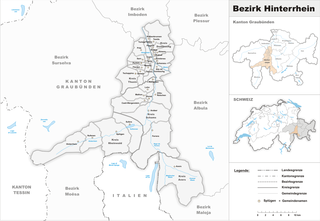
Hinterrhein District (Bezirk Hinterrhein)
- district in Switzerland
 Hiking in Hinterrhein District
The Hinterrhein District, located in the Graubünden region of Switzerland, offers breathtaking landscapes and a variety of hiking opportunities that cater to different skill levels. Here’s what you need to know about hiking in this scenic area:
Terrain and Scenery:
- Diverse Landscapes: The Hinterrhein District is known for its stunning natural beauty, including rugged mountains, deep valleys, and pristine rivers. Hikers can enjoy views of alpine meadows, dramatic rock formations, and glacial landscapes.
- Wildlife: The area is home to a variety of wildlife, including ibex, chamois, and diverse bird species, making it a great destination for nature enthusiasts.
Popular Hiking Trails:
- The Via Albula: This trail runs through the region and connects several villages, offering panoramic views and access to cultural landmarks along the way.
- Rhein Gorge (Grand Canyon of Switzerland): A spectacular hiking route that follows the Rhine River, providing dramatic views of the gorge and its geological formations.
- Alp Flix: A great area for day hikes, with routes that take you through beautiful alpine scenery and to picturesque mountain huts.
Hiking Tips:
- Plan Ahead: Always check the weather and trail conditions before heading out, as conditions can change rapidly in the mountains.
- Stay Hydrated: Carry enough water, especially during warmer months. There may not always be water sources along the trails.
- Proper Gear: Wear appropriate footwear and clothing for the terrain and weather. Waterproof gear is advisable in case of unexpected rain.
- Respect Nature: Follow the Leave No Trace principles by staying on marked trails and not disturbing wildlife.
Accessibility:
- The Hinterrhein District is accessible by public transport, with train connections to nearby towns. Make sure to check the local schedules and routes.
- If you're not familiar with the area, consider joining guided hikes offered by local tour operators. This can enhance your experience by providing insights into the local flora, fauna, and geology.
Safety:
- Always inform someone of your hiking plans and expected return time.
- Be mindful of your physical limits, especially when tackling more challenging hikes or high-altitude paths.
Overall, the Hinterrhein District is a fantastic destination for hikers seeking both adventure and tranquility amid stunning natural beauty. Enjoy your hike!
- Country:

- Capital: Thusis
- Licence Plate Code: GR
- Coordinates: 46° 35' 9" N, 9° 25' 34" E


- GPS tracks (wikiloc): [Link]
- AboveSeaLevel: 1987 м m
- Area: 617.63 sq km
- Wikipedia en: wiki(en)
- Wikipedia: wiki(de)
- Wikidata storage: Wikidata: Q546871
- Wikipedia Commons Category: [Link]
- Freebase ID: [/m/09411m]
- GeoNames ID: Alt: [6458759]
- HDS ID: [1496]
Includes regions:


Avers
- subdistrict in the canton of Graubünden, Switzerland
Avers is a picturesque region in the canton of Graubünden, Switzerland, known for its stunning landscapes, diverse flora and fauna, and rich cultural heritage. It offers a variety of hiking trails suitable for different skill levels, making it a great destination for both casual walkers and experienced hikers....
- Country:

- Coordinates: 46° 28' 0" N, 9° 30' 0" E


- GPS tracks (wikiloc): [Link]
- AboveSeaLevel: 2366 м m
- Area: 93.12 sq km


Domleschg
- subdistrict in the canton of Graubünden, Switzerland
Domleschg, located in the canton of Graubünden in Switzerland, is a fantastic region for hiking enthusiasts. The area is known for its beautiful landscapes, charming villages, and a network of well-marked trails that cater to various skill levels. Here are some highlights of hiking in Domleschg:...
- Country:

- Coordinates: 46° 43' 0" N, 9° 26' 0" E


- GPS tracks (wikiloc): [Link]
- AboveSeaLevel: 844 м m
- Area: 73.94 sq km


Thusis
- subdistrict in the canton of Graubünden, Switzerland
Thusis, located in the canton of Graubünden in Switzerland, is an excellent destination for hiking enthusiasts. Nestled in the Rhine Valley and surrounded by the stunning landscapes of the Swiss Alps, the area offers a wide range of trails suitable for various skill levels, from leisurely walks to challenging mountain hikes....


Rheinwald
- subdistrict in the canton of Graubünden, Switzerland
Rheinwald, located in the canton of Graubünden in Switzerland, offers a beautiful backdrop for hiking enthusiasts. The region is characterized by its stunning alpine landscapes, clear rivers, and quaint Swiss villages, making it a great destination for hikers of various skill levels....
- Country:

- Coordinates: 46° 32' 46" N, 9° 18' 0" E


- GPS tracks (wikiloc): [Link]
- Area: 171.94 sq km


Schams
- subdistrict in the canton of Graubünden, Switzerland
Schams is a picturesque region located in the canton of Graubünden in Switzerland. Known for its stunning alpine landscapes, Schams offers a range of hiking opportunities for outdoor enthusiasts of all skill levels. Here’s what you can expect when hiking in Schams:...
