
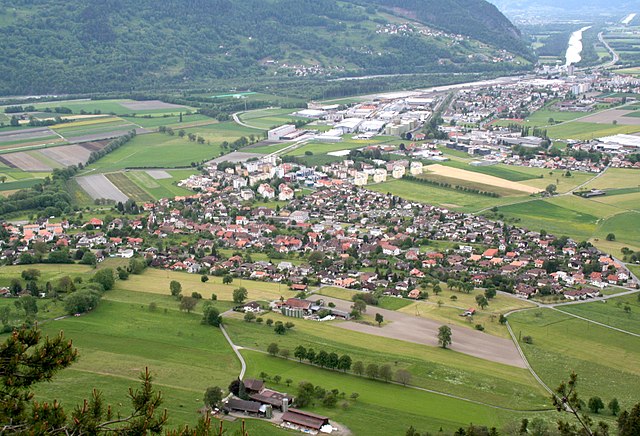
Graubünden (Kanton Graubünden)


- canton of Switzerland
 Hiking in Graubünden
The Canton of Grisons, or Graubünden, is a breathtaking region in Switzerland known for its stunning landscapes, diverse hiking trails, and rich cultural heritage. Here are some highlights of hiking in this beautiful area:
1.
- Alpine Landscapes: Grisons is home to the Swiss Alps, featuring dramatic peaks, alpine meadows, and glacial lakes. The varied altitudes provide an array of ecosystems and flora.
- Valleys and Passes: The region includes several picturesque valleys, such as the Engadine and the Rhine Valley, and numerous mountain passes that offer scenic hikes.
2.
- There are over 2,000 kilometers of marked hiking trails, ranging from easy walks to challenging alpine hikes. Trails are well-maintained and cater to all levels of hikers.
- Some popular routes include:
- The Sentiero dei Fiori: A beautiful flower trail near Maloja.
- The Via Engiadina: A scenic path along the Engadine valley.
- The Rhine Gorge: Often referred to as the "Grand Canyon of Switzerland," this trail offers stunning views of rugged valleys and unique rock formations.
3.
- The Swiss National Park, located in the eastern part of Grisons, is the country's only national park. It offers pristine nature and plenty of wildlife, including chamois, marmots, and golden eagles. There are well-marked trails that allow hikers to explore its vast landscapes while respecting the park's regulations.
4.
- The Canton of Grisons is rich in local culture, including Romansh traditions. Hikers will discover charming villages such as Zernez, Scuol, and Pontresina, where one can experience local cuisine and hospitality.
5.
- Summer: This is the most popular season for hiking, with trails accessible and a wide variety of wildflowers in bloom.
- Winter: While traditional hiking might be limited due to snow, snowshoeing and winter hiking trails are available. Some trails offer stunning winter scenery.
6.
- Weather can change rapidly in the mountains, so it’s crucial to check forecasts and prepare accordingly.
- Carry sufficient water, snacks, a map (or GPS), and proper gear, including sturdy hiking boots and weather-appropriate clothing.
7.
- If you're new to the area or want a more informative experience, consider joining guided hikes. Local guides can provide insights into the natural and cultural history of the region.
Whether you're seeking a leisurely stroll or an adventurous climb, the Canton of Grisons offers incredible opportunities for all kinds of hikers. Always remember to tread lightly and respect the natural environment while enjoying the stunning beauty of this unique Swiss region.
- Country:

- Capital: Chur
- Licence Plate Code: GR
- Coordinates: 46° 45' 0" N, 9° 30' 0" E


- GPS tracks (wikiloc): [Link]
- AboveSeaLevel: 585 м m
- Area: 7105.39 sq km
- Web site: http://www.gr.ch
- Wikipedia en: wiki(en)
- Wikipedia: wiki(de)
- Wikidata storage: Wikidata: Q11925
- Wikipedia Commons Gallery: [Link]
- Wikipedia Commons Category: [Link]
- Freebase ID: [/m/016s3x]
- GeoNames ID: Alt: [2660522]
- BnF ID: [11931604r]
- VIAF ID: Alt: [142538950]
- OSM relation ID: [1686631]
- GND ID: Alt: [4021881-8]
- archINFORM location ID: [2790]
- Library of Congress authority ID: Alt: [n81003377]
- MusicBrainz area ID: [360dc1f1-2174-468b-8a49-4c57ce705172]
- SUDOC authorities ID: [027228517]
- Encyclopædia Britannica Online ID: [place/Graubunden]
- Gran Enciclopèdia Catalana ID: [0031171]
- Encyclopædia Universalis ID: [grisons]
- HDS ID: [7391]
- EMLO location ID: [7b90af62-6e1f-4acb-ab01-c0177161c606]
- ISNI: Alt: [0000 0001 2348 1343]
- NKCR AUT ID: [ge339113]
- NUTS code: [CH056]
- Klexikon article ID: [Graubünden]
- Global Anabaptist Mennonite Encyclopedia Online ID: [Grisons (Switzerland)]
- STW Thesaurus for Economics ID: [16963-2]
- SELIBR ID: [147031]
- Lexicon istoric retic ID: [1168]
- ISO 3166-2 code: CH-GR
- FIPS 10-4 (countries and regions): SZ09
Includes regions:


Maloja District
- district of the canton of Graubünden, Switzerland
Hiking in Maloja District
Maloja District, located in the Swiss Alps, is known for its stunning scenery, diverse landscapes, and a plethora of hiking opportunities suitable for various skill levels. Here are some highlights for those considering a hike in Maloja:...
- Country:
- Capital: Samedan
- Licence Plate Code: GR
- Coordinates: 46° 24' 9" N, 9° 41' 42" E
- GPS tracks (wikiloc): [Link]
- AboveSeaLevel: 2456 м m
- Area: 973.61 sq km

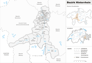
Hinterrhein District
- district in Switzerland
Hiking in Hinterrhein District
The Hinterrhein District, located in the Graubünden region of Switzerland, offers breathtaking landscapes and a variety of hiking opportunities that cater to different skill levels. Here’s what you need to know about hiking in this scenic area:...
- Country:
- Capital: Thusis
- Licence Plate Code: GR
- Coordinates: 46° 35' 9" N, 9° 25' 34" E
- GPS tracks (wikiloc): [Link]
- AboveSeaLevel: 1987 м m
- Area: 617.63 sq km

Landquart District
- district in Switzerland
Hiking in Landquart District
The Landquart District, located in the canton of Graubünden in Switzerland, offers a stunning selection of hiking opportunities for all levels of hikers. The area is surrounded by beautiful mountain landscapes, offering a mix of lush valleys, alpine meadows, and impressive peaks....
- Country:
- Licence Plate Code: GR
- Coordinates: 46° 58' 0" N, 9° 33' 0" E
- GPS tracks (wikiloc): [Link]
- AboveSeaLevel: 522 м m
- Area: 193.23 sq km


Plessur District
- district in Switzerland
Hiking in Plessur District
Plessur District, located in the canton of Graubünden in Switzerland, is a beautiful area for hiking, characterized by its stunning landscapes, dense forests, and rugged alpine terrain. Here are some highlights and essential tips for hiking in this region:...
- Country:
- Capital: Chur
- Licence Plate Code: GR
- Coordinates: 46° 49' 5" N, 9° 36' 23" E
- GPS tracks (wikiloc): [Link]
- AboveSeaLevel: 914 м m
- Area: 266.75 sq km

Prättigau/Davos District
- former district in Switzerland
Hiking in Prättigau/Davos District
Prättigau-Davos is a stunning region in the eastern part of Switzerland, nestled between the impressive Alps. It's known for its picturesque landscapes, charming villages, and numerous outdoor activities, particularly hiking. Here’s an overview of what makes hiking in Prättigau-Davos special:...
- Country:
- Capital: Davos
- Coordinates: 46° 48' 0" N, 9° 49' 0" E
- GPS tracks (wikiloc): [Link]
- AboveSeaLevel: 1870 м m
- Area: 853.4 sq km

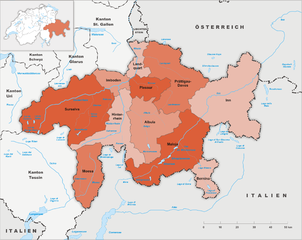
Bernina District
- district in Switzerland
Hiking in Bernina District
The Bernina District, located in the Graubünden region of Switzerland, offers some of the most stunning hiking opportunities in the Swiss Alps. This area is characterized by its breathtaking landscapes, including towering peaks, lush valleys, glacial lakes, and charming alpine villages. Here are some highlights of hiking in this picturesque district:...
- Country:
- Capital: Poschiavo
- Licence Plate Code: GR
- Coordinates: 46° 20' 8" N, 10° 4' 40" E
- GPS tracks (wikiloc): [Link]
- AboveSeaLevel: 1474 м m
- Area: 237.3 sq km


Inn District
- district in Switzerland
Hiking in Inn District
The Inn District, or the Engadin Valley, in Switzerland is a picturesque region that offers a wealth of opportunities for hiking enthusiasts. Situated in the canton of Graubünden, it is known for its stunning alpine scenery, charming villages, and diverse trails suitable for all experience levels. Here are some key highlights and tips for hiking in this beautiful area:...
- Country:
- Capital: Scuol
- Licence Plate Code: GR
- Coordinates: 46° 48' 0" N, 10° 17' 0" E
- GPS tracks (wikiloc): [Link]
- AboveSeaLevel: 2112 м m
- Area: 1196.56 sq km


Albula District
- district in Switzerland
Hiking in Albula District
The Albula District, located in the canton of Graubünden in Switzerland, is a stunning area renowned for its breathtaking landscapes, diverse trails, and rich cultural heritage. Here’s some information about hiking in this picturesque region:...
- Country:
- Licence Plate Code: GR
- Coordinates: 46° 39' 43" N, 9° 34' 32" E
- GPS tracks (wikiloc): [Link]
- AboveSeaLevel: 2169 м m
- Area: 693.47 sq km

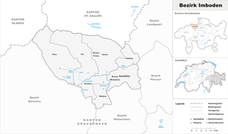
Imboden District
- district in Switzerland
Hiking in Imboden District
The Imboden District, located in the eastern part of Switzerland in the canton of Graubünden, is known for its stunning landscapes and diverse hiking opportunities. Here are some highlights and tips for hiking in this area:...
- Country:
- Capital: Domat/Ems
- Licence Plate Code: GR
- Coordinates: 46° 51' 0" N, 9° 21' 0" E
- GPS tracks (wikiloc): [Link]
- AboveSeaLevel: 1062 м m
- Area: 203.81 sq km

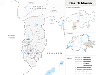
Moesa District
- district in Switzerland
Hiking in Moesa District
Moesa District, located in the scenic area of Graubünden in Switzerland, offers a range of hiking opportunities for outdoor enthusiasts. The region is characterized by its stunning alpine landscapes, charming villages, and diverse flora and fauna. Here are some highlights and tips for hiking in the Moesa District:...
- Country:
- Licence Plate Code: GR
- Coordinates: 46° 14' 0" N, 9° 7' 0" E
- GPS tracks (wikiloc): [Link]
- AboveSeaLevel: 1791 м m
- Area: 496.03 sq km


Surselva District
- district in Switzerland
Hiking in Surselva District
Surselva District, located in the canton of Graubünden in Switzerland, is an excellent destination for hiking enthusiasts, known for its stunning natural landscapes, diverse terrain, and rich cultural heritage. Here are some highlights and tips for hiking in the Surselva area:...
- Country:
- Licence Plate Code: GR
- Coordinates: 46° 46' 0" N, 9° 12' 0" E
- GPS tracks (wikiloc): [Link]
- AboveSeaLevel: 2379 м m
- Area: 1373.54 sq km
Shares border with regions:
Glarus
- canton of Switzerland
Hiking in Glarus
The Canton of Glarus, located in central Switzerland, is a stunning destination for hikers, offering a variety of trails that cater to different skill levels. Nestled between the rugged Alps and picturesque valleys, the region is known for its breathtaking landscapes, diverse flora and fauna, and charming villages....
- Country:
- Capital: Glarus
- Licence Plate Code: GL
- Coordinates: 46° 59' 0" N, 9° 4' 0" E
- GPS tracks (wikiloc): [Link]
- AboveSeaLevel: 472 м m
- Area: 685.3 sq km
- Population: 40000
- Web site: [Link]

Lombardy
- administrative region in Northern Italy
Hiking in Lombardy
Lombardy, a region in northern Italy, is known for its stunning landscapes, ranging from the Alps in the north to picturesque lakes, rolling hills, and charming towns. Hiking in Lombardy offers a variety of trails suitable for all levels, whether you're a beginner looking for an easy stroll or an experienced hiker seeking challenging mountain routes....
- Country:

- Capital: Milan
- Coordinates: 45° 39' 0" N, 9° 57' 0" E
- GPS tracks (wikiloc): [Link]
- Area: 23863.65 sq km
- Population: 10023876
- Web site: [Link]

Trentino-South Tyrol
- autonomous region in Northern Italy
Hiking in Trentino-South Tyrol
Trentino-Alto Adige/Südtirol is a stunning region in northern Italy, known for its breathtaking landscapes, rich culture, and a diverse array of hiking opportunities. Here's an overview of what to expect when hiking in this beautiful area:...
- Country:
- Capital: Trento
- Coordinates: 46° 23' 0" N, 11° 25' 0" E
- GPS tracks (wikiloc): [Link]
- AboveSeaLevel: 749 м m
- Area: 13606.87 sq km
- Population: 1068264
- Web site: [Link]


Uri
- canton of Switzerland
Hiking in Uri
The Canton of Uri, situated in central Switzerland, offers stunning landscapes and a range of hiking opportunities for all skill levels. Here’s a general overview of hiking in this picturesque region:...
- Country:
- Capital: Altdorf
- Licence Plate Code: UR
- Coordinates: 46° 47' 0" N, 8° 37' 0" E
- GPS tracks (wikiloc): [Link]
- AboveSeaLevel: 447 м m
- Area: 1076.57 sq km
- Population: 36145
- Web site: [Link]


Ticino
- canton of Switzerland
Hiking in Ticino
The Canton of Ticino, located in southern Switzerland, is a breathtaking destination for hiking enthusiasts. Known for its stunning landscapes, picturesque villages, and mild Mediterranean climate, Ticino offers a variety of trails suitable for all levels of hikers. Here are some highlights:...
- Country:
- Capital: Chiasso
- Local Dialing Code: 091
- Licence Plate Code: TI
- Coordinates: 46° 19' 0" N, 8° 49' 0" E
- GPS tracks (wikiloc): [Link]
- AboveSeaLevel: 238 м m
- Area: 2812.15 sq km
- Web site: [Link]


Canton of St. Gallen
- canton of Switzerland
Hiking in Canton of St. Gallen
The Canton of St. Gallen, located in eastern Switzerland, is a fantastic destination for hiking enthusiasts, boasting a diverse range of trails that cater to various skill levels and interests. Here's an overview of what you can expect:...
- Country:
- Capital: St. Gallen
- Licence Plate Code: SG
- Coordinates: 47° 20' 0" N, 9° 10' 0" E
- GPS tracks (wikiloc): [Link]
- AboveSeaLevel: 668 м m
- Area: 2030.75 sq km
- Population: 75538
- Web site: [Link]


South Tyrol
- autonomous province of Italy
Hiking in South Tyrol
South Tyrol, located in northern Italy, is a paradise for hikers and outdoor enthusiasts. This stunning region is characterized by its dramatic landscapes, which include the towering peaks of the Dolomites, lush valleys, and picturesque alpine meadows. Here are some key points about hiking in South Tyrol:...
- Country:
- Capital: Bolzano
- Postal Code: 39010–39059; 39100
- Local Dialing Code: 0471; 0463; 0474; 0473; 0472
- Licence Plate Code: BZ
- Coordinates: 46° 30' 0" N, 11° 20' 0" E
- GPS tracks (wikiloc): [Link]
- Area: 7400.43 sq km
- Population: 550432
- Web site: [Link]


Province of Como
- province of Italy
Hiking in Province of Como
The Province of Como, located in the northern part of Italy, is a spectacular destination for hiking, thanks to its stunning landscapes, rich cultural history, and pristine natural areas. The region is home to Lake Como, which is surrounded by mountains and hills, providing a diverse range of hiking trails for all levels of hikers....
- Country:
- Capital: Como
- Postal Code: 22100
- Local Dialing Code: 004191; 0331; 02; 0344; 031
- Licence Plate Code: CO
- Coordinates: 45° 49' 0" N, 9° 5' 0" E
- GPS tracks (wikiloc): [Link]
- Area: 1288.07 sq km
- Web site: [Link]

Province of Sondrio
- province of Italy
Hiking in Province of Sondrio
The Province of Sondrio, located in northern Italy's Lombardy region, is a stunning destination for hiking enthusiasts. Known for its diverse landscapes, which include the impressive Alps, lush valleys, and picturesque villages, Sondrio offers a wide range of hiking trails suitable for all levels of experience....
- Country:
- Capital: Sondrio
- Postal Code: 23100, 23010-23038
- Licence Plate Code: SO
- Coordinates: 46° 21' 37" N, 9° 56' 38" E
- GPS tracks (wikiloc): [Link]
- Area: 3211.9 sq km
- Web site: [Link]


Vorarlberg
- federal state of Austria
Hiking in Vorarlberg
Vorarlberg, the westernmost province of Austria, is a fantastic destination for hiking enthusiasts. Nestled between the Alps and the Rhine River, it offers a diverse landscape with breathtaking views, lush valleys, and well-marked trails catering to various skill levels....
- Country:

- Capital: Bregenz
- Coordinates: 47° 14' 37" N, 9° 53' 38" E
- GPS tracks (wikiloc): [Link]
- AboveSeaLevel: 1063 м m
- Area: 2601.48 sq km
- Population: 388711
- Web site: [Link]


Tyrol
- federal state in western Austria
Hiking in Tyrol
Tyrol, located in the Austrian Alps, is a paradise for hiking enthusiasts, offering a diverse array of trails that cater to all skill levels. The landscape is characterized by stunning mountain vistas, lush valleys, sparkling lakes, and charming alpine villages, making it a perfect setting for outdoor activities....
- Country:
- Capital: Innsbruck
- Coordinates: 47° 16' 0" N, 11° 24' 0" E
- GPS tracks (wikiloc): [Link]
- AboveSeaLevel: 605 м m
- Area: 12647.71 sq km
- Population: 739002
- Web site: [Link]

Gravedona ed Uniti
- Italian comune
Hiking in Gravedona ed Uniti
Gravedona ed Uniti is a charming town located on the northern shores of Lake Como in Italy, known for its beautiful landscapes and rich history. Hiking in this area offers a variety of trails that cater to different skill levels, providing stunning views of the lake, surrounding mountains, and picturesque villages....
- Country:
- Postal Code: 22015
- Local Dialing Code: 0344
- Licence Plate Code: CO
- Coordinates: 46° 9' 0" N, 9° 18' 0" E
- GPS tracks (wikiloc): [Link]
- AboveSeaLevel: 201 м m
- Area: 39.85 sq km
- Population: 4198
- Web site: [Link]
Livo
- comune of Italy
Hiking in Livo
Livo is a picturesque village located in the province of Sondrio in Lombardy, Italy. It is situated in the northern part of the region, close to the shores of Lake Como, and is surrounded by beautiful mountains and lush landscapes. Hiking in Livo offers various trails that cater to different skill levels, making it an excellent destination for both novice and experienced hikers....
- Country:
- Postal Code: 22010
- Local Dialing Code: 0344
- Licence Plate Code: CO
- Coordinates: 46° 10' 0" N, 9° 18' 0" E
- GPS tracks (wikiloc): [Link]
- AboveSeaLevel: 675 м m
- Area: 33.13 sq km
- Population: 171
- Web site: [Link]
Dosso del Liro
- Italian comune
Hiking in Dosso del Liro
Dosso del Liro is a beautiful destination for hiking enthusiasts, located in the northern part of Italy, close to the shores of Lake Como in the Lombardy region. The area is characterized by its picturesque landscapes, lush greenery, and stunning views of the surrounding mountains and valleys. Here are some key points to consider when planning a hiking trip to Dosso del Liro:...
- Country:
- Postal Code: 22015
- Local Dialing Code: 0344
- Licence Plate Code: CO
- Coordinates: 46° 10' 0" N, 9° 16' 0" E
- GPS tracks (wikiloc): [Link]
- AboveSeaLevel: 650 м m
- Area: 23.49 sq km
- Population: 262
- Web site: [Link]