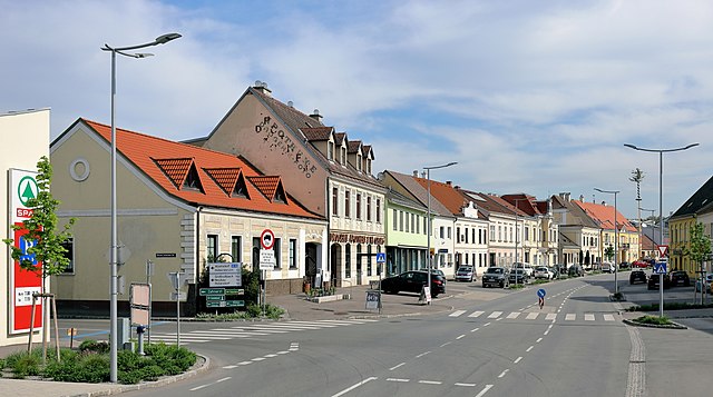
Hohenruppersdorf (Hohenruppersdorf)
- municipality in Austria
Hohenruppersdorf is a charming village located in Austria, specifically in the state of Lower Austria. While it may not be a globally recognized hiking destination, it offers a peaceful natural environment that is great for outdoor enthusiasts who enjoy exploring rural landscapes.
Hiking Opportunities
-
Scenic Trails: The surrounding areas of Hohenruppersdorf have various trails that provide picturesque views of the countryside, vineyards, and farmlands. Check local maps for marked hiking routes.
-
Nature Walks: The region is characterized by flatlands and gentle hills, making it suitable for leisurely hikes and nature walks. You can expect to encounter diverse flora and fauna in the area.
-
Proximity to Bigger Trails: Hohenruppersdorf is close to larger hiking areas in Lower Austria, such as the Vienna Woods, which offer a wider range of hikes for different skill levels. You can easily combine a day in Hohenruppersdorf with a trek in these larger regions.
-
Cultural Attractions: Consider integrating your hike with visits to local attractions, such as historical sites or vineyards, which are often found in the countryside of Lower Austria.
Recommendations
- Prepare Adequately: Make sure to carry enough water, wear appropriate hiking footwear, and bring snacks. The trails may not have many facilities.
- Local Guides: If you desire a more informative experience, look for local hiking guides who can share insights about the area's geology, history, and culture.
- Seasonal Considerations: The best times to hike in this area are during late spring through autumn when the weather is mild and the scenery is at its best.
Important Tips
- Check Weather Conditions: As this region can experience variable weather, check forecasts before heading out.
- Trail Conditions: Occasionally, trails may be affected by rain or other weather conditions, so ensure to choose routes that are accessible.
Overall, Hohenruppersdorf can be a delightful spot for a relaxed hiking experience, especially if you enjoy serene settings and want to take advantage of the local culture and nature.
- Country:

- Postal Code: 2223
- Local Dialing Code: 02574
- Licence Plate Code: GF
- Coordinates: 48° 27' 0" N, 16° 39' 0" E


- GPS tracks (wikiloc): [Link]
- AboveSeaLevel: 244 м m
- Area: 21.37 sq km
- Population: 910
- Web site: http://www.hohenruppersdorf.gv.at
- Wikipedia en: wiki(en)
- Wikipedia: wiki(de)
- Wikidata storage: Wikidata: Q426328
- Wikipedia Commons Category: [Link]
- Freebase ID: [/m/02qtsq9]
- GeoNames ID: Alt: [2775733]
- VIAF ID: Alt: [246650911]
- GND ID: Alt: [4282678-0]
- Austrian municipality key: [30828]
Shares border with regions:

Ebenthal, Lower Austria
- municipality in Austria
 Hiking in Ebenthal, Lower Austria
Ebenthal, located in Lower Austria, offers a variety of hiking opportunities that showcase the region's natural beauty. The landscape features rolling hills, vineyards, and some forested areas, making it an excellent destination for both casual walkers and more experienced hikers....
- Country:

- Postal Code: 2251
- Local Dialing Code: 02538
- Licence Plate Code: GF
- Coordinates: 48° 26' 0" N, 16° 47' 0" E


- GPS tracks (wikiloc): [Link]
- AboveSeaLevel: 176 м m
- Area: 18.14 sq km
- Population: 923
- Web site: [Link]

Gaweinstal
- municipality in Austria
Gaweinstal is a small village located in the Lower Austria region of Austria, known for its beautiful landscapes and proximity to the natural beauty of the country. While not a major hiking destination like some larger national parks or mountainous areas, Gaweinstal offers several opportunities for outdoor enthusiasts to explore the surrounding countryside. Here’s what you can expect when hiking in this area:...
- Country:

- Postal Code: 2191
- Local Dialing Code: 02574
- Licence Plate Code: MI
- Coordinates: 48° 28' 41" N, 16° 35' 21" E


- GPS tracks (wikiloc): [Link]
- AboveSeaLevel: 199 м m
- Area: 51.71 sq km
- Population: 3947
- Web site: [Link]

Sulz im Weinviertel
- municipality in Austria
Sulz im Weinviertel, located in the picturesque Weinviertel region of Austria, offers a variety of hiking opportunities that showcase the beauty of its rolling landscapes, vineyards, and charming villages. Here's what you can expect when hiking in this part of Austria:...
- Country:

- Postal Code: 2224
- Local Dialing Code: 02534
- Licence Plate Code: GF
- Coordinates: 48° 29' 0" N, 16° 40' 0" E


- GPS tracks (wikiloc): [Link]
- AboveSeaLevel: 227 м m
- Area: 31.37 sq km
- Population: 1189
- Web site: [Link]

Spannberg
- municipality in Austria
Spannberg, located in Lower Austria, is a great destination for hiking enthusiasts. The area is characterized by its picturesque landscapes, rolling hills, and lush greenery, making it perfect for outdoor activities....
- Country:

- Postal Code: 2244
- Local Dialing Code: 02538
- Licence Plate Code: GF
- Coordinates: 48° 27' 0" N, 16° 43' 0" E


- GPS tracks (wikiloc): [Link]
- AboveSeaLevel: 186 м m
- Area: 19.51 sq km
- Population: 1010
- Web site: [Link]
Matzen-Raggendorf
- municipality in Austria
Matzen-Raggendorf, located in Lower Austria, is a beautiful area for hiking, surrounded by picturesque landscapes, rolling hills, and lush forests. Here’s what you need to know about hiking in this region:...
- Country:

- Postal Code: 2243
- Local Dialing Code: 02289
- Licence Plate Code: GF
- Coordinates: 48° 24' 0" N, 16° 42' 0" E


- GPS tracks (wikiloc): [Link]
- AboveSeaLevel: 189 м m
- Area: 35.59 sq km
- Population: 2794
- Web site: [Link]