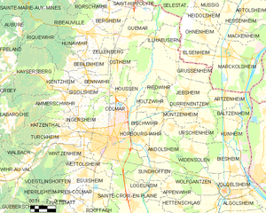
Horbourg-Wihr (Horbourg-Wihr)

- commune in Haut-Rhin, France
- Country:

- Postal Code: 68180
- Coordinates: 48° 4' 46" N, 7° 23' 40" E


- GPS tracks (wikiloc): [Link]
- AboveSeaLevel: 186 м m
- Area: 9.42 sq km
- Population: 5709
- Web site: http://www.horbourg-wihr.fr/
- Wikipedia en: wiki(en)
- Wikipedia: wiki(fr)
- Wikidata storage: Wikidata: Q83412
- Wikipedia Commons Category: [Link]
- Freebase ID: [/m/03nssz6]
- Freebase ID: [/m/03nssz6]
- GeoNames ID: Alt: [6617437]
- GeoNames ID: Alt: [6617437]
- SIREN number: [216801456]
- SIREN number: [216801456]
- BnF ID: [15271847r]
- BnF ID: [15271847r]
- VIAF ID: Alt: [244277878]
- VIAF ID: Alt: [244277878]
- OSM relation ID: [83847]
- OSM relation ID: [83847]
- INSEE municipality code: 68145
- INSEE municipality code: 68145
Shares border with regions:

Colmar
- commune in Haut-Rhin, France
- Country:
- Postal Code: 68000
- Local Dialing Code: 389
- Coordinates: 48° 4' 52" N, 7° 21' 18" E
- GPS tracks (wikiloc): [Link]
- AboveSeaLevel: 197 м m
- Area: 66.57 sq km
- Population: 70284
- Web site: [Link]
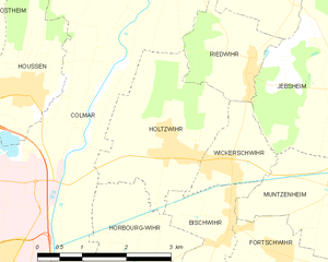
Holtzwihr
- former commune in Haut-Rhin, France
- Country:
- Postal Code: 68320
- Coordinates: 48° 6' 45" N, 7° 25' 14" E
- GPS tracks (wikiloc): [Link]
- Area: 6.45 sq km
- Population: 1344
- Web site: [Link]


Bischwihr
- commune in Haut-Rhin, France
- Country:
- Postal Code: 68320
- Coordinates: 48° 5' 46" N, 7° 26' 13" E
- GPS tracks (wikiloc): [Link]
- Area: 3.23 sq km
- Population: 964


Andolsheim
- commune in Haut-Rhin, France
- Country:
- Postal Code: 68280
- Coordinates: 48° 3' 45" N, 7° 25' 1" E
- GPS tracks (wikiloc): [Link]
- Area: 11.6 sq km
- Population: 2170


Sundhoffen
- commune in Haut-Rhin, France
- Country:
- Postal Code: 68280
- Coordinates: 48° 2' 36" N, 7° 24' 49" E
- GPS tracks (wikiloc): [Link]
- Area: 12.75 sq km
- Population: 1955