Hostun (Hostun)

- commune in Drôme, France
 Hiking in Hostun
Hostun, located in the Drôme department of southeastern France, offers beautiful landscapes and a variety of hiking opportunities. This area is characterized by its rolling hills, picturesque villages, and access to the natural beauty of the Vercors Regional Natural Park nearby. Here are some highlights regarding hiking in Hostun and its surroundings:
Trails and Routes:
-
Local Paths: Hostun has its own network of walking paths that can take you through charming countryside, vineyards, and orchards. Look for marked trails that offer varying levels of difficulty.
-
Vercors Regional Natural Park: Just a short drive from Hostun, the Vercors is known for its stunning cliffs, deep gorges, and extensive hiking trails. Popular routes include those leading to the high plateaus, where you can experience breathtaking views.
-
Historical Routes: Some trails in the area might also include historical sites or remnants of ancient settlements, providing a blend of nature and history.
Flora and Fauna:
The region is rich in biodiversity. As you hike, you may encounter various wildlife such as deer, numerous bird species, and diverse plant life, particularly if you venture into the Vercors. Be sure to take in the seasonal changes, which can drastically alter the landscape.
Tips for Hiking in Hostun:
-
Preparation: Always check the weather conditions before heading out, as they can change rapidly in mountainous regions. Dress in layers and carry waterproof gear if necessary.
-
Navigation: Carry a map or download hiking apps that can provide offline trails, as cell coverage may be limited in remote areas.
-
Respect Nature: Stick to marked trails to protect the local flora and fauna. Follow local guidelines for waste disposal and wildlife interactions.
-
Local Guidance: Consider joining guided hikes if you want more insight into the local culture and environment. Local guides can navigate you through lesser-known trails and provide valuable knowledge.
Overall, hiking in Hostun and its nearby areas can be a rewarding experience, offering both scenic beauty and the chance to immerse yourself in the natural landscape of southeastern France. Whether you're a novice or an experienced hiker, there's plenty to explore!
- Country:

- Postal Code: 26730
- Coordinates: 45° 2' 22" N, 5° 11' 53" E


- GPS tracks (wikiloc): [Link]
- Area: 18.24 sq km
- Population: 963
- Wikipedia en: wiki(en)
- Wikipedia: wiki(fr)
- Wikidata storage: Wikidata: Q477760
- Wikipedia Commons Category: [Link]
- Freebase ID: [/m/03mhgp3]
- GeoNames ID: Alt: [6430100]
- SIREN number: [212601496]
- BnF ID: [152530108]
- PACTOLS thesaurus ID: [pcrtKXHqlLEkue]
- INSEE municipality code: 26149
Shares border with regions:
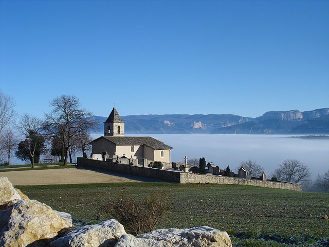

Rochechinard
- commune in Drôme, France
Hiking in Rochechinard
Rochechinard is a beautiful area located in the French Alps, known for its stunning landscapes, diverse flora and fauna, and a variety of hiking routes that cater to different skill levels. Here are some key points to consider if you’re planning a hiking trip in Rochechinard:...
- Country:
- Postal Code: 26190
- Coordinates: 45° 2' 3" N, 5° 15' 12" E
- GPS tracks (wikiloc): [Link]
- Area: 9.78 sq km
- Population: 110


La Baume-d'Hostun
- commune in Drôme, France
Hiking in La Baume-d'Hostun
La Baume-d'Hostun is a charming village located in the Drôme department of southeastern France, surrounded by beautiful natural landscapes that are perfect for hiking. The area features a mix of rolling hills, forests, and scenic views of the surrounding mountains, making it an excellent destination for hikers of all levels....
- Country:
- Postal Code: 26730
- Coordinates: 45° 3' 19" N, 5° 13' 38" E
- GPS tracks (wikiloc): [Link]
- Area: 8.46 sq km
- Population: 562


Eymeux
- commune in Drôme, France
Hiking in Eymeux
Eymeux is a charming village located in the Auvergne-Rhône-Alpes region of France, known for its picturesque landscapes and natural beauty. Hiking in and around Eymeux offers a variety of trails that cater to different skill levels, making it a fantastic destination for outdoor enthusiasts....
- Country:
- Postal Code: 26730
- Coordinates: 45° 4' 41" N, 5° 10' 42" E
- GPS tracks (wikiloc): [Link]
- Area: 9.88 sq km
- Population: 1046


Beauregard-Baret
- commune in Drôme, France
Hiking in Beauregard-Baret
Beauregard-Baret is a picturesque region located in the Drôme department of southeastern France. Known for its beautiful landscapes, it's a fantastic destination for hiking enthusiasts of all levels....
- Country:
- Postal Code: 26300
- Coordinates: 45° 0' 57" N, 5° 9' 5" E
- GPS tracks (wikiloc): [Link]
- Area: 23.44 sq km
- Population: 808
- Web site: [Link]

Jaillans
- commune in Drôme, France
Hiking in Jaillans
Jaillans is a small commune in the Drôme department of the Auvergne-Rhône-Alpes region in southeastern France. While it may not be as well-known as some larger hiking destinations, it offers picturesque landscapes and a tranquil environment, making it a great spot for hiking enthusiasts who prefer less crowded paths....
- Country:
- Postal Code: 26300
- Coordinates: 45° 1' 41" N, 5° 10' 28" E
- GPS tracks (wikiloc): [Link]
- Area: 9.04 sq km
- Population: 896