Houssen (Houssen)

- commune in Haut-Rhin, France
- Country:

- Postal Code: 68125
- Coordinates: 48° 7' 32" N, 7° 22' 41" E


- GPS tracks (wikiloc): [Link]
- Area: 6.7 sq km
- Population: 2081
- Wikipedia en: wiki(en)
- Wikipedia: wiki(fr)
- Wikidata storage: Wikidata: Q83411
- Wikipedia Commons Category: [Link]
- Freebase ID: [/m/03m4df3]
- Freebase ID: [/m/03m4df3]
- GeoNames ID: Alt: [3013058]
- GeoNames ID: Alt: [3013058]
- SIREN number: [216801464]
- SIREN number: [216801464]
- BnF ID: [152718483]
- BnF ID: [152718483]
- PACTOLS thesaurus ID: [pcrtrBHU8A8hqG]
- PACTOLS thesaurus ID: [pcrtrBHU8A8hqG]
- WOEID: [595007]
- WOEID: [595007]
- Trismegistos Geo ID: [34969]
- Trismegistos Geo ID: [34969]
- INSEE municipality code: 68146
- INSEE municipality code: 68146
Shares border with regions:

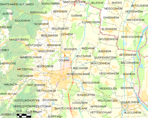
Colmar
- commune in Haut-Rhin, France
- Country:
- Postal Code: 68000
- Local Dialing Code: 389
- Coordinates: 48° 4' 52" N, 7° 21' 18" E
- GPS tracks (wikiloc): [Link]
- AboveSeaLevel: 197 м m
- Area: 66.57 sq km
- Population: 70284
- Web site: [Link]


Ostheim
- commune in Haut-Rhin, France
- Country:
- Postal Code: 68150
- Coordinates: 48° 9' 36" N, 7° 22' 14" E
- GPS tracks (wikiloc): [Link]
- Area: 8.16 sq km
- Population: 1581
- Web site: [Link]

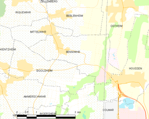
Bennwihr
- commune in Haut-Rhin, France
- Country:
- Postal Code: 68630
- Coordinates: 48° 8' 37" N, 7° 19' 31" E
- GPS tracks (wikiloc): [Link]
- Area: 6.59 sq km
- Population: 1292