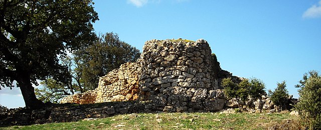
Isili (Isili)
%20-%202016.svg)
- Italian comune
 Hiking in Isili
Isili, located in Sardinia, Italy, is a lesser-known but beautiful destination for hiking enthusiasts. Surrounded by stunning landscapes, it showcases the unique natural beauty of the region, including rolling hills, lush forests, and traditional Sardinian countryside.
Here are some key points about hiking in Isili:
Trails and Routes
- Monte Gennargentu: This is the highest mountain range in Sardinia and offers challenging trails with breathtaking views. While not in Isili itself, it is accessible for a day hike.
- Local Trails: Isili features several local trails suitable for different skill levels. These trails can lead you through scenic hills, past ancient ruins, and along picturesque lakes like Lake Isili, where you can enjoy a mix of nature and local wildlife.
Flora and Fauna
- The region is rich in biodiversity, with opportunities to spot various plant species, birds, and small mammals. The lush Mediterranean vegetation adds to the scenic beauty of the hikes.
Best Time to Hike
- Spring and Fall: These are the best seasons for hiking in Isili, as the temperatures are milder, and the landscape is vibrant with flowers and green foliage.
- Summer: It can get hot, so early morning or late afternoon hikes are advisable. Hydration is key during these months.
Preparation Tips
- Gear: Wear sturdy hiking boots and appropriate clothing for the weather. A hat and sunscreen are also recommended, especially in summer.
- Hydration: Carry sufficient water, particularly on longer hikes. There may not always be available water sources along the trails.
- Maps and Guides: While many trails are marked, having a map or a local guide can enhance your hiking experience and help navigate.
Local Culture
- Besides hiking, Isili offers cultural experiences such as traditional Sardinian cuisine and crafts. Consider trying local dishes and visiting artisanal shops in town post-hike.
Exploring Isili through hiking not only allows you to appreciate the natural beauty but also to connect with the rich cultural heritage of Sardinia. Enjoy your adventure!
- Country:

- Postal Code: 09056
- Local Dialing Code: 0782
- Licence Plate Code: SU
- Coordinates: 39° 44' 29" N, 9° 6' 35" E


- GPS tracks (wikiloc): [Link]
- AboveSeaLevel: 523 м m
- Area: 67.84 sq km
- Population: 2659
- Web site: http://www.comune.isili.ca.it/
- Wikipedia en: wiki(en)
- Wikipedia: wiki(it)
- Wikidata storage: Wikidata: Q284061
- Wikipedia Commons Category: [Link]
- Freebase ID: [/m/0gqvn2]
- Freebase ID: [/m/0gqvn2]
- GeoNames ID: Alt: [6537856]
- GeoNames ID: Alt: [6537856]
- VIAF ID: Alt: [137069752]
- VIAF ID: Alt: [137069752]
- OSM relation ID: [40065]
- OSM relation ID: [40065]
- WOEID: [716691]
- WOEID: [716691]
- Digital Atlas of the Roman Empire ID: [41638]
- Digital Atlas of the Roman Empire ID: [41638]
- ISTAT ID: 111036
- ISTAT ID: 111036
- Italian cadastre code: E336
- Italian cadastre code: E336
Shares border with regions:
Gergei
- Italian comune
Hiking in Gergei
Gergei is a small village in the Sulcis region of Sardinia, Italy, known for its beautiful landscapes and rich natural environment. Hiking in Gergei and the surrounding areas can be a delightful experience, offering a chance to explore the unique flora and fauna of this region, as well as historical and cultural sites....
- Country:
- Postal Code: 08030
- Local Dialing Code: 0782
- Licence Plate Code: SU
- Coordinates: 39° 41' 58" N, 9° 6' 3" E
- GPS tracks (wikiloc): [Link]
- AboveSeaLevel: 374 м m
- Area: 36.18 sq km
- Population: 1218
- Web site: [Link]


Nuragus
- Italian comune
Hiking in Nuragus
Nuragus is a charming village located in the province of Nuoro, Sardinia, Italy. It's surrounded by beautiful landscapes characterized by rolling hills, lush greenery, and stunning views. While it may not be as well-known as some other hiking destinations in Sardinia, it offers a unique experience for hikers looking to explore more off-the-beaten-path areas....
- Country:
- Postal Code: 08030
- Local Dialing Code: 0782
- Licence Plate Code: SU
- Coordinates: 39° 46' 39" N, 9° 2' 12" E
- GPS tracks (wikiloc): [Link]
- AboveSeaLevel: 359 м m
- Area: 19.9 sq km
- Population: 901
- Web site: [Link]


Nurallao
- Italian comune
Hiking in Nurallao
Nurallao, located in the Nuoro region of Sardinia, Italy, offers a variety of hiking opportunities that allow you to explore its stunning natural landscapes, including mountains, forests, and rivers. Here are some highlights and tips for hiking in Nurallao:...
- Country:
- Postal Code: 09058
- Local Dialing Code: 0782
- Licence Plate Code: SU
- Coordinates: 39° 47' 28" N, 9° 4' 49" E
- GPS tracks (wikiloc): [Link]
- AboveSeaLevel: 403 м m
- Area: 34.76 sq km
- Population: 1250
- Web site: [Link]
Nurri
- Italian comune
Hiking in Nurri
Nurri is a small town located in the province of Nuoro in Sardinia, Italy. It's not a widely known hiking destination, but the surrounding areas offer some fantastic opportunities for outdoor activities, including hiking, thanks to Sardinia's stunning landscapes, rugged terrain, and diverse ecosystems....
- Country:
- Postal Code: 08035
- Local Dialing Code: 0782
- Licence Plate Code: SU
- Coordinates: 39° 42' 41" N, 9° 13' 49" E
- GPS tracks (wikiloc): [Link]
- AboveSeaLevel: 612 м m
- Area: 73.67 sq km
- Population: 2154
- Web site: [Link]
Serri
- Italian comune
Hiking in Serri
Serri, located in the beautiful landscape of the Sarrabus region in Sardinia, Italy, offers a variety of hiking opportunities for both novice and experienced hikers. The area is known for its rugged terrain, stunning natural scenery, and rich biodiversity, making it an ideal destination for outdoor enthusiasts....
- Country:
- Postal Code: 08030
- Local Dialing Code: 0782
- Licence Plate Code: SU
- Coordinates: 39° 42' 5" N, 9° 8' 41" E
- GPS tracks (wikiloc): [Link]
- AboveSeaLevel: 640 м m
- Area: 19.18 sq km
- Population: 644
- Web site: [Link]

Villanova Tulo
- Italian comune
Hiking in Villanova Tulo
Villanova Tulo is a charming village located in the heart of Sardinia, Italy. It is known for its beautiful landscapes, vibrant culture, and proximity to various hiking trails that attract nature lovers and outdoor enthusiasts....
- Country:
- Postal Code: 08030
- Local Dialing Code: 0782
- Licence Plate Code: SU
- Coordinates: 39° 46' 49" N, 9° 12' 48" E
- GPS tracks (wikiloc): [Link]
- AboveSeaLevel: 600 м m
- Area: 40.45 sq km
- Population: 1091
- Web site: [Link]


Gesturi
- Italian comune
Hiking in Gesturi
Gesturi is a charming village located in the heart of Sardinia, Italy, known for its stunning natural landscapes and rich cultural heritage. Hiking in this area can offer a wonderful mix of scenic views, historical sites, and the chance to explore Sardinian flora and fauna. Here are some details to consider when hiking in Gesturi:...
- Country:
- Postal Code: 09020
- Local Dialing Code: 070
- Licence Plate Code: SU
- Coordinates: 39° 43' 59" N, 9° 1' 13" E
- GPS tracks (wikiloc): [Link]
- AboveSeaLevel: 310 м m
- Area: 46.83 sq km
- Population: 1224
- Web site: [Link]


Laconi
- Italian comune
Hiking in Laconi
Laconi, a town in the province of Oristano in Sardinia, Italy, offers a unique hiking experience characterized by its diverse landscapes, rich history, and cultural heritage. Here are some highlights of hiking in Laconi:...
- Country:
- Postal Code: 08034
- Local Dialing Code: 0782
- Licence Plate Code: OR
- Coordinates: 39° 51' 10" N, 9° 3' 7" E
- GPS tracks (wikiloc): [Link]
- AboveSeaLevel: 555 м m
- Area: 124.75 sq km
- Population: 2302
- Web site: [Link]