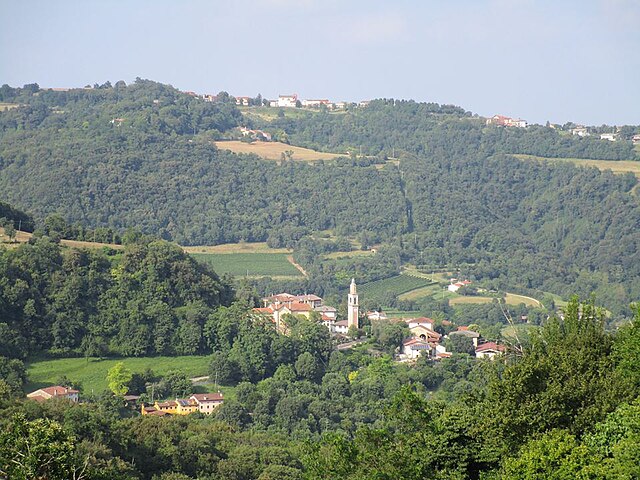
Isola Vicentina (Isola Vicentina)
.svg)
- Italian comune
 Hiking in Isola Vicentina
Isola Vicentina, located in the province of Vicenza in northern Italy, offers beautiful landscapes ideal for hiking enthusiasts. Surrounded by lush greenery, rolling hills, and scenic views of the Lessini Mountains and the nearby Berici Hills, this area is rich in natural beauty.
Hiking Trails
-
Sentiero dei Crocifissi: This trail offers a scenic journey through the surrounding countryside. It's a relatively easy hike with beautiful views and is great for families.
-
Cima Guglielmo: A more challenging hike that rewards you with panoramic views from the top. The trail can be steep in places but is well-marked.
-
Berici Hills: Although not directly in Isola Vicentina, the Berici Hills are easily accessible and provide numerous trails for all skill levels. You can explore hidden chapels, vineyards, and charming villages.
Tips for Hiking in Isola Vicentina
- Gear Up: Wear comfortable hiking shoes and dress in layers as the weather can change.
- Stay Hydrated: Bring plenty of water, especially during warmer months.
- Respect Nature: Stick to marked trails and follow Leave No Trace principles to preserve the area's natural beauty.
- Check Weather Conditions: Always check the weather before heading out to ensure a safe hiking experience.
Nearby Attractions
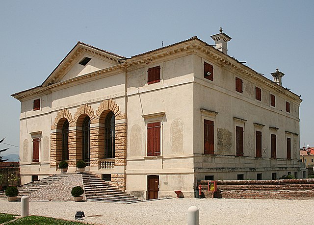
- Villa La Rotonda: A famous architectural gem located nearby that can be part of your hiking journey.
- Local Cuisine: After a hike, explore local eateries to enjoy regional delicacies like polenta and herbal infusions.
Overall, Isola Vicentina is a great destination for hikers looking to explore the natural landscapes of northern Italy while enjoying a rich cultural experience.
- Country:

- Postal Code: 36033
- Local Dialing Code: 0444
- Licence Plate Code: VI
- Coordinates: 45° 38' 0" N, 11° 27' 0" E


- GPS tracks (wikiloc): [Link]
- AboveSeaLevel: 55 м m
- Area: 26.48 sq km
- Population: 10242
- Web site: http://www.comune.isola-vicentina.vi.it
- Wikipedia en: wiki(en)
- Wikipedia: wiki(it)
- Wikidata storage: Wikidata: Q47044
- Wikipedia Commons Category: [Link]
- Freebase ID: [/m/0fxwrc]
- GeoNames ID: Alt: [6541814]
- VIAF ID: Alt: [249441226]
- OSM relation ID: [45460]
- UN/LOCODE: [ITISV]
- ISTAT ID: 024048
- Italian cadastre code: E354
Shares border with regions:

Gambugliano
- Italian comune
Hiking in Gambugliano
Gambugliano is a picturesque village located in the province of Vicenza, Italy. It's situated in the foothills of the Lessini Mountains, providing a charming backdrop for outdoor activities, including hiking. Here are some highlights about hiking in and around Gambugliano:...
- Country:
- Postal Code: 36050
- Local Dialing Code: 0444
- Licence Plate Code: VI
- Coordinates: 45° 35' 0" N, 11° 26' 0" E
- GPS tracks (wikiloc): [Link]
- AboveSeaLevel: 133 м m
- Area: 7.95 sq km
- Population: 837
- Web site: [Link]


Costabissara
- Italian comune
Hiking in Costabissara
Costabissara is a small town located in the province of Vicenza, in the Veneto region of Italy. While it may not be as widely known as other hiking destinations in the region, it offers a charming backdrop for outdoor enthusiasts who are looking to explore the beautiful natural landscapes of the area....
- Country:
- Postal Code: 36030
- Local Dialing Code: 0444
- Licence Plate Code: VI
- Coordinates: 45° 35' 0" N, 11° 29' 0" E
- GPS tracks (wikiloc): [Link]
- AboveSeaLevel: 51 м m
- Area: 13.13 sq km
- Population: 7658
- Web site: [Link]


Castelgomberto
- Italian comune
Hiking in Castelgomberto
Castelgomberto is a charming town located in the province of Vicenza, in the Veneto region of northern Italy. While it might not be as widely known for hiking as some of its neighboring areas, there are still several outdoor opportunities nearby that are worth exploring....
- Country:
- Postal Code: 36070
- Local Dialing Code: 0445
- Licence Plate Code: VI
- Coordinates: 45° 35' 0" N, 11° 24' 0" E
- GPS tracks (wikiloc): [Link]
- AboveSeaLevel: 145 м m
- Area: 17.44 sq km
- Population: 6188
- Web site: [Link]


Villaverla
- Italian comune
Hiking in Villaverla
Villaverla is a small town in the province of Vicenza, in the Veneto region of Italy. While it may not be widely known as a hiking destination, it offers access to beautiful natural landscapes and scenic trails in the surrounding areas. Here are some things to consider for hiking in and around Villaverla:...
- Country:
- Postal Code: 36030
- Local Dialing Code: 0445
- Licence Plate Code: VI
- Coordinates: 45° 39' 0" N, 11° 30' 0" E
- GPS tracks (wikiloc): [Link]
- AboveSeaLevel: 75 м m
- Area: 15.79 sq km
- Population: 6138
- Web site: [Link]
Malo
- Italian comune
Hiking in Malo
Malo, located in the province of Vicenza in the Veneto region of Italy, is a charming town that offers beautiful hiking opportunities in the surrounding landscapes. The area is characterized by its rolling hills, vineyards, and scenic views of the nearby foothills of the Alps....
- Country:
- Postal Code: 36034
- Local Dialing Code: 0445
- Licence Plate Code: VI
- Coordinates: 45° 39' 29" N, 11° 24' 17" E
- GPS tracks (wikiloc): [Link]
- AboveSeaLevel: 116 м m
- Area: 30.53 sq km
- Population: 14855
- Web site: [Link]

Caldogno
- Italian comune
Hiking in Caldogno
Caldogno, located in the province of Vicenza in northern Italy, offers several beautiful hiking opportunities that allow you to explore its natural beauty and cultural heritage. Here's what you need to know about hiking in Caldogno:...
- Country:
- Postal Code: 36030
- Local Dialing Code: 0444
- Licence Plate Code: VI
- Coordinates: 45° 36' 28" N, 11° 30' 10" E
- GPS tracks (wikiloc): [Link]
- AboveSeaLevel: 52 м m
- Area: 15.88 sq km
- Population: 11274
- Web site: [Link]
Cornedo Vicentino
- Italian comune
Hiking in Cornedo Vicentino
Cornedo Vicentino is a picturesque town located in the Veneto region of Italy, surrounded by beautiful natural landscapes that are perfect for hiking enthusiasts. The area offers a variety of trails that cater to different skill levels, from leisurely walks to more challenging hikes....
- Country:
- Postal Code: 36073
- Local Dialing Code: 0445
- Licence Plate Code: VI
- Coordinates: 45° 37' 0" N, 11° 21' 0" E
- GPS tracks (wikiloc): [Link]
- AboveSeaLevel: 200 м m
- Area: 23.56 sq km
- Population: 11982
- Web site: [Link]