Isola delle Femmine (Isola delle Femmine)
.svg)
- Italian comune
 Hiking in Isola delle Femmine
Isola delle Femmine is a small island located off the coast of Sicily, Italy, near the town of the same name. While the island itself is relatively small and doesn’t have extensive hiking trails like larger mountain ranges, it does offer some beautiful outdoor opportunities and scenic views.
Hiking Opportunities:
-
Coastal Walks:
- The island features a number of coastal paths where you can enjoy stunning views of the Mediterranean Sea, especially around the rugged cliffs and beaches. These walks can be quite scenic, offering a chance to explore coves and enjoy the local flora and fauna.
-
Nature Reserves:
- Isola delle Femmine is part of a protected marine area, and the surrounding waters are home to diverse marine life. While the island itself may not have extensive trails, the area allows for exploration of coastal ecosystems and opportunities for nature photography.
-
Nearby Hikes:
- If you're looking for more rigorous hiking options, you might consider exploring the nearby mainland areas, such as Monte Gallo or the Zingaro Reserve, both of which offer more extensive trail systems and breathtaking landscapes.
Tips for Hiking in Isola delle Femmine:
- Wear Good Footwear: Since trails can be rocky and uneven, it's important to wear sturdy hiking shoes.
- Stay Hydrated: Bring plenty of water, especially during the warmer months.
- Timing and Weather: The best time to hike is typically in the spring or fall, as summer can be very hot.
- Explore Low Tide: If you're interested in the coastal areas, check tide schedules to explore rocky shores and pools.
- Respect Nature: Follow marked paths and be mindful of the local wildlife and plant life.
Additional Activities:
- Besides hiking, the area is great for swimming, snorkeling, and watching birds, as it's a stopover for many migrating species. The views at sunset are also spectacular, making it worthwhile to stay later in the day.
While Isola delle Femmine may not be a traditional hiking destination, it does offer a mix of natural beauty and tranquility suitable for outdoor enthusiasts. If you’re in the region, it’s a lovely spot to spend a day exploring!
- Country:

- Postal Code: 90040
- Local Dialing Code: 091
- Licence Plate Code: PA
- Coordinates: 38° 12' 0" N, 13° 15' 0" E


- GPS tracks (wikiloc): [Link]
- AboveSeaLevel: 7 м m
- Area: 3.57 sq km
- Population: 7249
- Web site: http://www.comune.isoladellefemmine.pa.it/
- Wikipedia en: wiki(en)
- Wikipedia: wiki(it)
- Wikidata storage: Wikidata: Q489865
- Wikipedia Commons Category: [Link]
- Freebase ID: [/m/0fq56w]
- GeoNames ID: Alt: [6539131]
- VIAF ID: Alt: [248759377]
- OSM relation ID: [39571]
- UN/LOCODE: [ITIDF]
- ISTAT ID: 082043
- Italian cadastre code: E350
Shares border with regions:

Palermo
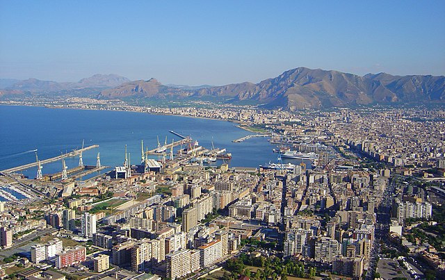
- Italian city, capital of Sicily
Hiking in Palermo
Palermo, the capital of Sicily, offers a diverse range of hiking opportunities that showcase the stunning natural landscapes, historic sites, and rich culture of the region. Here are some key highlights for hiking in and around Palermo:...
- Country:
- Postal Code: 90121–90151; 90100
- Local Dialing Code: 091
- Licence Plate Code: PA
- Coordinates: 38° 6' 56" N, 13° 21' 41" E
- GPS tracks (wikiloc): [Link]
- AboveSeaLevel: 14 м m
- Area: 158.9 sq km
- Population: 674435
- Web site: [Link]


Torretta
- Italian comune
Hiking in Torretta
Torretta is a charming destination for hikers, known for its scenic landscapes and diverse natural features. While it may not be as famous as some larger hiking destinations, it offers a variety of trails suitable for different skill levels and interests....
- Country:
- Postal Code: 90040
- Local Dialing Code: 091
- Licence Plate Code: PA
- Coordinates: 38° 7' 49" N, 13° 14' 8" E
- GPS tracks (wikiloc): [Link]
- AboveSeaLevel: 325 м m
- Area: 25.54 sq km
- Population: 4263
- Web site: [Link]


Capaci
- Italian comune
Hiking in Capaci
Capaci is a charming coastal town located in Sicily, Italy, just a short distance from Palermo. While it’s not as widely recognized for hiking as some other areas in Sicily, there are picturesque trails and routes in and around Capaci that can offer a beautiful hiking experience....
- Country:
- Postal Code: 90040
- Local Dialing Code: 091
- Licence Plate Code: PA
- Coordinates: 38° 10' 0" N, 13° 14' 0" E
- GPS tracks (wikiloc): [Link]
- AboveSeaLevel: 51 м m
- Area: 6.12 sq km
- Population: 11549
- Web site: [Link]