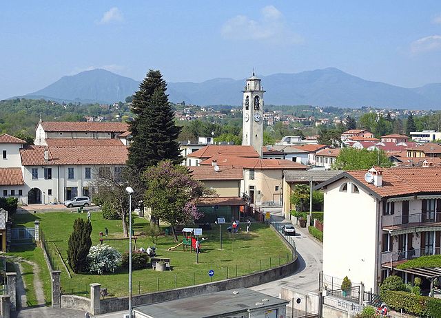
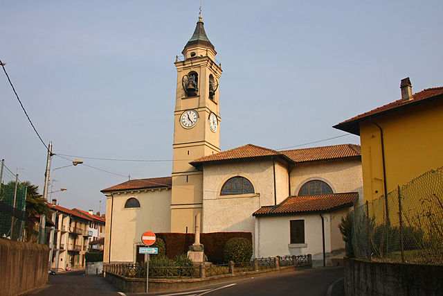
Ispra (Ispra)
.svg)
- Italian comune
 Hiking in Ispra
Ispra is a charming town located by Lake Maggiore in the Lombardy region of northern Italy. It offers a variety of hiking opportunities for outdoor enthusiasts of all experience levels. Here are some highlights and tips for hiking in and around Ispra:
Hiking Trails
-
Sentiero del Cardinale: A well-marked trail that offers stunning views of Lake Maggiore and the surrounding mountains. This path is suitable for moderate hikers and provides a chance to enjoy the natural beauty of the area.
-
Monte Campione: For more challenging hikes, consider heading towards Monte Campione. The ascent offers panoramic views and a chance to see various flora and fauna along the way.
-
Riviera dei Fiori: This coastal trail allows hikers to traverse scenic spots along the lakeside, with opportunities to take breaks at small beaches or enjoy local eateries.
Tips for Hiking in Ispra
-
Preparation: Wear appropriate hiking shoes and carry a map or GPS device. The terrain can vary, so be ready for both gentle walks and more strenuous climbs.
-
Weather Awareness: Check the weather forecast before heading out, as conditions can change rapidly in mountainous areas.
-
Hydration and Snacks: Always bring enough water and some snacks to keep your energy levels up, especially on longer hikes.
-
Respect Nature: Stay on marked trails, respect the local wildlife, and carry out any trash you bring in.
-
Local Resources: Visit the Ispra tourist information center for up-to-date maps, trail conditions, and potential guided hikes.
Nearby Attractions
If you're looking to combine hiking with some cultural experiences, you can also explore the nearby town of Angera, which has a castle and lakeside promenades, or take a ferry ride on Lake Maggiore to see beautiful lakeside villages.
Hiking in Ispra and its surroundings not only provides a fantastic way to enjoy nature but also to immerse yourself in the stunning landscapes of northern Italy.
- Country:

- Postal Code: 21027
- Local Dialing Code: 0332
- Licence Plate Code: VA
- Coordinates: 45° 49' 0" N, 8° 37' 0" E


- GPS tracks (wikiloc): [Link]
- AboveSeaLevel: 220 м m
- Area: 15.91 sq km
- Population: 5276
- Web site: http://www.comune.ispra.va.it/
- Wikipedia en: wiki(en)
- Wikipedia: wiki(it)
- Wikidata storage: Wikidata: Q40297
- Wikipedia Commons Category: [Link]
- Freebase ID: [/m/0b11f5]
- GeoNames ID: Alt: [6536487]
- VIAF ID: Alt: [148891816]
- OSM relation ID: [46149]
- archINFORM location ID: [5600]
- MusicBrainz area ID: [e5dcfe3f-0eaa-4a23-bec4-8e38dc9e14f9]
- UN/LOCODE: [ITISR]
- ISTAT ID: 012084
- Italian cadastre code: E367
Shares border with regions:

Lesa
- Italian comune
Hiking in Lesa
Lesa is a charming town located on the western shore of Lake Maggiore in the Piedmont region of Italy. It offers a beautiful setting for hiking enthusiasts, with a mix of lakeside trails, mountainous paths, and lush landscapes. Here are some details about hiking in and around Lesa:...
- Country:
- Postal Code: 28040
- Local Dialing Code: 0322
- Licence Plate Code: NO
- Coordinates: 45° 50' 0" N, 8° 34' 0" E
- GPS tracks (wikiloc): [Link]
- AboveSeaLevel: 198 м m
- Area: 13.58 sq km
- Population: 2236
- Web site: [Link]

Belgirate
- Italian comune
Hiking in Belgirate
Belgirate is a charming village located on the shores of Lake Maggiore in Northern Italy. It is a fantastic hiking destination, offering breathtaking views of the lake and the surrounding mountains. Here are some highlights and tips for hiking in and around Belgirate:...
- Country:
- Postal Code: 28832
- Local Dialing Code: 0322
- Licence Plate Code: VB
- Coordinates: 45° 50' 0" N, 8° 34' 0" E
- GPS tracks (wikiloc): [Link]
- AboveSeaLevel: 199 м m
- Area: 7.13 sq km
- Population: 509
- Web site: [Link]

Brebbia
- Italian comune
Hiking in Brebbia
Brebbia, located in the province of Varese in Italy, offers a charming setting for hiking enthusiasts. Nestled near Lake Maggiore and the surrounding Lombardy hills, the area is rich in natural beauty, with a variety of trails that cater to different skill levels. Here are some aspects to consider when hiking in and around Brebbia:...
- Country:
- Postal Code: 21020
- Local Dialing Code: 0332
- Licence Plate Code: VA
- Coordinates: 45° 50' 0" N, 8° 39' 0" E
- GPS tracks (wikiloc): [Link]
- AboveSeaLevel: 235 м m
- Area: 6.87 sq km
- Population: 3239
- Web site: [Link]

Ranco
- Italian comune
Hiking in Ranco
Ranco, located in the Lombardy region of Italy, is a charming small town on the shores of Lake Maggiore. The scenic beauty of the area, combined with its mild climate, makes it an attractive destination for hikers and outdoor enthusiasts....
- Country:
- Postal Code: 21020
- Local Dialing Code: 0331
- Licence Plate Code: VA
- Coordinates: 45° 48' 0" N, 8° 34' 0" E
- GPS tracks (wikiloc): [Link]
- AboveSeaLevel: 214 м m
- Area: 6.76 sq km
- Population: 1289
- Web site: [Link]


Cadrezzate
- Italian comune
Hiking in Cadrezzate
Cadrezzate, located in the province of Varese in Italy, offers a charming environment for hiking enthusiasts. It's close to the beautiful natural landscapes of the Cuvio Valley and the nearby lakes. Here are some highlights and considerations for hiking in this area:...
- Country:
- Postal Code: 21020
- Local Dialing Code: 0331
- Licence Plate Code: VA
- Coordinates: 45° 47' 52" N, 8° 38' 37" E
- GPS tracks (wikiloc): [Link]
- AboveSeaLevel: 281 м m
- Area: 4.73 sq km
- Population: 1842
- Web site: [Link]
Travedona-Monate
- Italian comune
Hiking in Travedona-Monate
Travedona-Monate is a charming area located in the Lombardy region of Italy, near Lake Monate, not far from the more famous Lake Como and Lake Maggiore. The area is known for its natural beauty, tranquility, and outdoor activities, making it a lovely destination for hiking enthusiasts....
- Country:
- Postal Code: 21028
- Local Dialing Code: 0332
- Licence Plate Code: VA
- Coordinates: 45° 48' 14" N, 8° 40' 21" E
- GPS tracks (wikiloc): [Link]
- AboveSeaLevel: 273 м m
- Area: 9.6 sq km
- Population: 4120
- Web site: [Link]
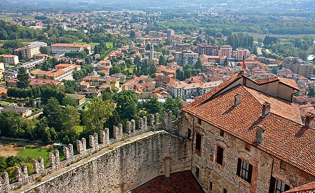

Angera
- Italian comune
Hiking in Angera
Angera, located on the shores of Lake Maggiore in Northern Italy, offers a range of hiking options that cater to different levels of experience. The area is known for its beautiful landscapes, scenic views of the lake and surrounding mountains, and charming historical features. Here are some highlights of hiking in Angera:...
- Country:
- Postal Code: 21021
- Local Dialing Code: 0331
- Licence Plate Code: VA
- Coordinates: 45° 46' 0" N, 8° 35' 0" E
- GPS tracks (wikiloc): [Link]
- AboveSeaLevel: 193 м m
- Area: 17.72 sq km
- Population: 5583
- Web site: [Link]