Izotges (Izotges)

- commune in Gers, France
- Country:

- Postal Code: 32400
- Coordinates: 43° 39' 5" N, 0° 0' 41" E


- GPS tracks (wikiloc): [Link]
- Area: 2.94 sq km
- Population: 106
- Wikipedia en: wiki(en)
- Wikipedia: wiki(fr)
- Wikidata storage: Wikidata: Q657727
- Wikipedia Commons Category: [Link]
- Freebase ID: [/m/03nrq43]
- Freebase ID: [/m/03nrq43]
- GeoNames ID: Alt: [6431933]
- GeoNames ID: Alt: [6431933]
- SIREN number: [213201619]
- SIREN number: [213201619]
- BnF ID: [152557471]
- BnF ID: [152557471]
- INSEE municipality code: 32161
- INSEE municipality code: 32161
Shares border with regions:

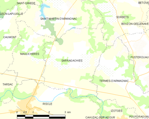
Sarragachies
- commune in Gers, France
- Country:
- Postal Code: 32400
- Coordinates: 43° 40' 59" N, 0° 3' 14" E
- GPS tracks (wikiloc): [Link]
- Area: 12.83 sq km
- Population: 257


Tasque
- commune in Gers, France
- Country:
- Postal Code: 32160
- Coordinates: 43° 38' 21" N, 0° 1' 9" E
- GPS tracks (wikiloc): [Link]
- Area: 10.02 sq km
- Population: 260

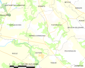
Termes-d'Armagnac
- commune in Gers, France
- Country:
- Postal Code: 32400
- Coordinates: 43° 40' 15" N, 0° 0' 38" E
- GPS tracks (wikiloc): [Link]
- Area: 10.05 sq km
- Population: 187

Riscle
- commune in Gers, France
- Country:
- Postal Code: 32400
- Coordinates: 43° 39' 24" N, 0° 5' 14" E
- GPS tracks (wikiloc): [Link]
- Area: 31.74 sq km
- Population: 1719


Cahuzac-sur-Adour
- commune in Gers, France
- Country:
- Postal Code: 32400
- Coordinates: 43° 38' 20" N, 0° 1' 24" E
- GPS tracks (wikiloc): [Link]
- AboveSeaLevel: 120 м m
- Area: 6.62 sq km
- Population: 230