Jalesches (Jalesches)

- commune in Creuse, France
- Country:

- Postal Code: 23270
- Coordinates: 46° 18' 4" N, 2° 5' 45" E


- GPS tracks (wikiloc): [Link]
- AboveSeaLevel: 450 м m
- Area: 8.45 sq km
- Population: 89
- Wikipedia en: wiki(en)
- Wikipedia: wiki(fr)
- Wikidata storage: Wikidata: Q1079405
- Wikipedia Commons Category: [Link]
- Freebase ID: [/m/03mfjgj]
- Freebase ID: [/m/03mfjgj]
- GeoNames ID: Alt: [6616134]
- GeoNames ID: Alt: [6616134]
- SIREN number: [212309801]
- SIREN number: [212309801]
- BnF ID: [152514864]
- BnF ID: [152514864]
- INSEE municipality code: 23098
- INSEE municipality code: 23098
Shares border with regions:

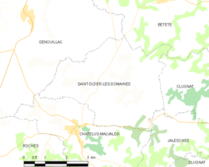
Saint-Dizier-les-Domaines
- commune in Creuse, France
- Country:
- Postal Code: 23270
- Coordinates: 46° 19' 8" N, 2° 2' 4" E
- GPS tracks (wikiloc): [Link]
- Area: 15.89 sq km
- Population: 185

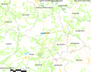
Ladapeyre
- commune in Creuse, France
- Country:
- Postal Code: 23270
- Coordinates: 46° 14' 54" N, 2° 2' 54" E
- GPS tracks (wikiloc): [Link]
- Area: 30.63 sq km
- Population: 355


Châtelus-Malvaleix
- commune in Creuse, France
- Country:
- Postal Code: 23270
- Coordinates: 46° 18' 16" N, 2° 1' 24" E
- GPS tracks (wikiloc): [Link]
- Area: 14.97 sq km
- Population: 581


Clugnat
- commune in Creuse, France
- Country:
- Postal Code: 23270
- Coordinates: 46° 18' 31" N, 2° 7' 5" E
- GPS tracks (wikiloc): [Link]
- Area: 42.42 sq km
- Population: 645