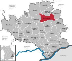
Johanniskirchen (Johanniskirchen)
- municipality of Germany
Johanniskirchen is a small community in Bavaria, Germany, known for its picturesque landscapes and scenic trails. Hiking in and around Johanniskirchen offers a great opportunity to experience the beauty of the Bavarian countryside. Here are some key points to consider if you're planning a hiking trip in this area:
Scenic Trails
-
Surrounding Nature: The region boasts lush forests, rolling hills, and peaceful farmland, making it perfect for nature lovers. You can find various trails offering different levels of difficulty.
-
Local Trails: There are well-marked hiking paths in the vicinity that cater to beginners and experienced hikers alike. Look for local maps or information boards that detail the routes.
-
The Bavarian Forest: A little further out, the Bavarian Forest National Park offers extensive hiking opportunities, with trails that allow you to explore vast wilderness areas.
Planning Your Hike
-
Trail Maps: It’s always a good idea to obtain a trail map or use a hiking app to navigate the routes. Local visitor centers can provide resources.
-
Weather Considerations: Check the weather before you hike, as conditions in Bavaria can change quickly. Dress in layers and pack rain gear if necessary.
-
Local Amenities: Johanniskirchen has basic amenities, but larger towns nearby may offer more options for food and accommodation.
Safety Tips
-
Stay Hydrated and Nourished: Bring plenty of water and snacks to keep your energy levels up during your hike.
-
Tell Someone Your Plans: Before heading out, let someone know your hiking route and expected return time, especially if you're hiking alone.
-
Wildlife Awareness: Be aware of the local wildlife and respect nature. Keep your distance from animals you may encounter.
Additional Activities
- If you enjoy photography, the area provides many stunning vistas, especially during sunrise or sunset.
- Consider visiting local attractions or historical sites after your hike, as Bavaria is rich in culture and history.
Overall, hiking in Johanniskirchen can be a rewarding experience for outdoor enthusiasts. Enjoy your adventure!
- Country:

- Postal Code: 84381
- Local Dialing Code: 08564
- Licence Plate Code: PAN
- Coordinates: 48° 32' 0" N, 12° 57' 0" E


- GPS tracks (wikiloc): [Link]
- AboveSeaLevel: 365 м m
- Area: 40.59 sq km
- Population: 2335
- Web site: https://www.johanniskirchen.de/
- Wikipedia en: wiki(en)
- Wikipedia: wiki(de)
- Wikidata storage: Wikidata: Q553798
- Wikipedia Commons Category: [Link]
- Freebase ID: [/m/02q830l]
- GeoNames ID: Alt: [2894771]
- VIAF ID: Alt: [233880136]
- OSM relation ID: [957048]
- GND ID: Alt: [4573154-8]
- TGN ID: [7154182]
- Bavarikon ID: [ODB_A00001621]
- German municipality key: 09277126
Shares border with regions:


Aidenbach
- municipality of Germany
Aidenbach, located in Bavaria, Germany, is a charming area that offers a variety of beautiful hiking trails. The region is characterized by its rolling hills, lush forests, and picturesque landscapes, making it a delightful destination for both novice and experienced hikers....
- Country:

- Postal Code: 94501
- Local Dialing Code: 08543
- Licence Plate Code: PA
- Coordinates: 48° 34' 0" N, 13° 6' 0" E


- GPS tracks (wikiloc): [Link]
- AboveSeaLevel: 345 м m
- Area: 17.1 sq km
- Population: 2323
- Web site: [Link]


Aldersbach
- municipality of Germany
Aldersbach, located in Bavaria, Germany, is a picturesque area that offers a variety of hiking opportunities. Nestled in a scenic landscape, it is an ideal destination for nature lovers and outdoor enthusiasts. Here are some highlights of hiking in Aldersbach:...
- Country:

- Postal Code: 94501
- Local Dialing Code: 08543
- Licence Plate Code: PA
- Coordinates: 48° 35' 17" N, 13° 5' 8" E


- GPS tracks (wikiloc): [Link]
- AboveSeaLevel: 328 м m
- Area: 45.8 sq km
- Population: 3574
- Web site: [Link]


Dietersburg
- municipality in Bavaria, Germany
Dietersburg, located in Bavaria, Germany, offers a variety of hiking opportunities for outdoor enthusiasts. While it may not be as well-known as some of the larger hiking destinations in Bavaria, it is surrounded by beautiful landscapes typical of the region, including rolling hills, forests, and picturesque countryside....
- Country:

- Postal Code: 84385; 84378
- Local Dialing Code: 08726; 08565; 08564; 08561
- Licence Plate Code: PAN
- Coordinates: 48° 30' 0" N, 12° 55' 0" E


- GPS tracks (wikiloc): [Link]
- AboveSeaLevel: 427 м m
- Area: 55.03 sq km
- Population: 3110
- Web site: [Link]


Roßbach
- municipality of Germany
Roßbach, located in Bavaria, Germany, is a picturesque village that serves as a great starting point for a variety of hiking adventures. The surrounding landscape is characterized by lush forests, rolling hills, and stunning views of the Bavarian countryside....
- Country:

- Postal Code: 94439
- Local Dialing Code: 08547
- Licence Plate Code: PAN
- Coordinates: 48° 36' 0" N, 12° 56' 0" E


- GPS tracks (wikiloc): [Link]
- AboveSeaLevel: 344 м m
- Area: 48.15 sq km
- Population: 2730
- Web site: [Link]


Arnstorf
- municipality of Germany
Arnstorf, located in Bavaria, Germany, is a charming village surrounded by beautiful landscapes that are perfect for hiking enthusiasts. The region offers a mix of gentle hills, meadows, and forests, making it suitable for various skill levels....
- Country:

- Postal Code: 94424
- Local Dialing Code: 08723
- Licence Plate Code: PAN
- Coordinates: 48° 34' 0" N, 12° 49' 0" E


- GPS tracks (wikiloc): [Link]
- AboveSeaLevel: 397 м m
- Area: 80.37 sq km
- Population: 5579
- Web site: [Link]

