Kirchberg (Kirchberg)

- commune in Haut-Rhin, France
- Country:

- Postal Code: 68290
- Coordinates: 47° 47' 48" N, 6° 57' 7" E


- GPS tracks (wikiloc): [Link]
- Area: 6.74 sq km
- Population: 801
- Wikipedia en: wiki(en)
- Wikipedia: wiki(fr)
- Wikidata storage: Wikidata: Q123039
- Wikipedia Commons Category: [Link]
- Freebase ID: [/m/03nst30]
- Freebase ID: [/m/03nst30]
- GeoNames ID: Alt: [6441497]
- GeoNames ID: Alt: [6441497]
- SIREN number: [216801670]
- SIREN number: [216801670]
- BnF ID: [152718692]
- BnF ID: [152718692]
- OSM relation ID: [80527]
- OSM relation ID: [80527]
- INSEE municipality code: 68167
- INSEE municipality code: 68167
Shares border with regions:


Niederbruck
- former commune in Haut-Rhin, France
- Country:
- Postal Code: 68290
- Coordinates: 47° 47' 5" N, 6° 58' 3" E
- GPS tracks (wikiloc): [Link]
- Area: 3.78 sq km
- Population: 437


Dolleren
- commune in Haut-Rhin, France
- Country:
- Postal Code: 68290
- Coordinates: 47° 48' 21" N, 6° 55' 55" E
- GPS tracks (wikiloc): [Link]
- Area: 8.37 sq km
- Population: 465

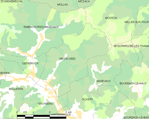
Wegscheid
- commune in Haut-Rhin, France
- Country:
- Postal Code: 68290
- Coordinates: 47° 47' 58" N, 6° 57' 29" E
- GPS tracks (wikiloc): [Link]
- Area: 10.06 sq km
- Population: 327


Sickert
- commune in Haut-Rhin, France
- Country:
- Postal Code: 68290
- Coordinates: 47° 47' 2" N, 6° 58' 44" E
- GPS tracks (wikiloc): [Link]
- Area: 5.12 sq km
- Population: 324

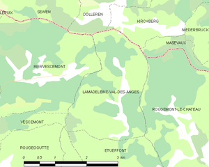
Lamadeleine-Val-des-Anges
- commune in Territoire de Belfort, France
- Country:
- Postal Code: 90170
- Coordinates: 47° 45' 40" N, 6° 54' 48" E
- GPS tracks (wikiloc): [Link]
- Area: 6.52 sq km
- Population: 39