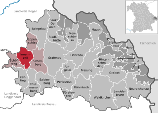
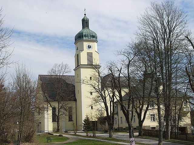
Kirchdorf im Wald (Kirchdorf im Wald)

- municipality of Germany
 Hiking in Kirchdorf im Wald
Kirchdorf im Wald is a charming village located in the Bavarian region of Germany, known for its beautiful natural landscapes and outdoor activities, particularly hiking. The area offers a variety of hiking trails suitable for different skill levels, making it a great destination for both novice and experienced hikers.
Notable Hiking Trails and Attractions:
-
Hiking Trails: Kirchdorf im Wald is surrounded by picturesque forests, hills, and meadows. Trails range from easy, family-friendly paths to more challenging routes for seasoned hikers. You can find well-marked paths that allow for scenic views of the Bavarian countryside.
-
Bavarian Forest National Park: Just a short drive away, this national park offers extensive hiking trails with stunning landscapes, diverse flora and fauna, and educational stations along the routes. The park is perfect for those looking to immerse themselves in nature.
-
Local Flora and Fauna: The area is rich in biodiversity. While hiking, you might encounter various wildlife, including deer and numerous bird species. The seasonal changes also bring a variety of wildflowers and foliage, enhancing the hiking experience.
-
Scenic Lookouts: Many trails lead to lookout points that offer breathtaking vistas of the surrounding countryside. These spots are perfect for a break to enjoy a packed lunch or a quiet moment in nature.
-
Cultural and Historical Sites: Along some hiking routes, you may come across historic churches, old mills, and traditional Bavarian architecture that adds cultural depth to your hikes.
Hiking Tips:
-
Preparation: Always check the weather before heading out and dress in layers to adapt to temperature changes. Good hiking boots are essential for navigating trails, especially those that might be rocky or uneven.
-
Navigation: While many trails are well-marked, consider bringing a map or using a GPS app to help with navigation.
-
Safety: Stay hydrated and bring enough food for your hike. It’s also a good idea to hike with someone else when possible, especially in less populated areas.
-
Respect the Environment: Follow Leave No Trace principles, such as staying on marked trails and taking your litter with you.
Overall, Kirchdorf im Wald provides an excellent base for exploring the natural beauty of Bavaria through its hiking opportunities. Whether you are looking for a serene day in nature or a more rigorous trek, the area has something to offer all hiking enthusiasts.
- Country:

- Postal Code: 94261
- Local Dialing Code: 09928
- Licence Plate Code: REG
- Coordinates: 48° 55' 0" N, 13° 16' 0" E


- GPS tracks (wikiloc): [Link]
- AboveSeaLevel: 684 м m
- Area: 30.55 sq km
- Population: 2054
- Web site: http://www.kirchdorf-im-wald.de
- Wikipedia en: wiki(en)
- Wikipedia: wiki(de)
- Wikidata storage: Wikidata: Q489164
- Wikipedia Commons Category: [Link]
- Freebase ID: [/m/02rg3k4]
- GeoNames ID: Alt: [2890599]
- VIAF ID: Alt: [239523560]
- OSM relation ID: [959167]
- GND ID: Alt: [4221930-9]
- archINFORM location ID: [13626]
- Historical Gazetteer (GOV) ID: [KIRALDJN68PW]
- Bavarikon ID: [ODB_A00001596]
- German municipality key: 09276127
Shares border with regions:


Frauenau
- municipality of Germany
Hiking in Frauenau
Frauenau is a picturesque village located in the Bavarian Forest in Germany, known for its beautiful landscapes and numerous hiking trails. The region is characterized by dense forests, rolling hills, and stunning views, making it a perfect destination for outdoor enthusiasts....
- Country:
- Postal Code: 94258
- Local Dialing Code: 09926
- Licence Plate Code: REG
- Coordinates: 48° 59' 0" N, 13° 18' 0" E
- GPS tracks (wikiloc): [Link]
- AboveSeaLevel: 616 м m
- Area: 60.1 sq km
- Population: 2697
- Web site: [Link]


Eppenschlag
- municipality of Germany
Hiking in Eppenschlag
Eppenschlag is a charming town located in the Bavaria region of Germany, surrounded by beautiful landscapes that offer a variety of hiking opportunities. Here are some highlights and tips for hiking in and around Eppenschlag:...
- Country:
- Postal Code: 94536
- Local Dialing Code: 09928
- Licence Plate Code: FRG
- Coordinates: 48° 53' 0" N, 13° 18' 0" E
- GPS tracks (wikiloc): [Link]
- AboveSeaLevel: 608 м m
- Area: 17.03 sq km
- Population: 890
- Web site: [Link]

Innernzell
- municipality of Germany
Hiking in Innernzell
Innernzell is a charming village located in Bavaria, Germany, known for its beautiful landscapes and outdoor recreational opportunities. Situated near the foothills of the Bavarian Forest, it's an excellent starting point for various hiking adventures....
- Country:
- Postal Code: 94548
- Local Dialing Code: 08554
- Licence Plate Code: FRG
- Coordinates: 48° 51' 0" N, 13° 16' 0" E
- GPS tracks (wikiloc): [Link]
- AboveSeaLevel: 636 м m
- Area: 22.12 sq km
- Population: 1542
- Web site: [Link]

Spiegelau
- municipality of Germany
Hiking in Spiegelau
Spiegelau, located in the Bavarian Forest National Park in Germany, is an excellent destination for hiking enthusiasts. The area is characterized by its beautiful landscapes, dense forests, and a variety of trails catering to different skill levels. Here’s what you can expect when hiking in and around Spiegelau:...
- Country:
- Postal Code: 94518
- Local Dialing Code: 08553
- Licence Plate Code: FRG
- Coordinates: 48° 55' 0" N, 13° 22' 0" E
- GPS tracks (wikiloc): [Link]
- AboveSeaLevel: 759 м m
- Area: 47.03 sq km
- Population: 4064
- Web site: [Link]