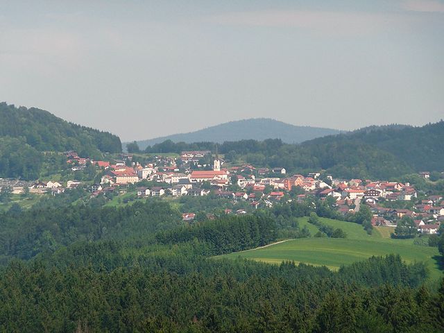
Spiegelau (Spiegelau)

- municipality of Germany
 Hiking in Spiegelau
Spiegelau, located in the Bavarian Forest National Park in Germany, is an excellent destination for hiking enthusiasts. The area is characterized by its beautiful landscapes, dense forests, and a variety of trails catering to different skill levels. Here’s what you can expect when hiking in and around Spiegelau:
Trails and Routes
-
Nature Trails: Spiegelau offers several well-marked nature trails that allow hikers to explore the local flora and fauna. The trails often run through lush forests and lead to scenic viewpoints.
-
Bavarian Forest National Park Trails: Many trails are accessible from Spiegelau that are part of the national park. You can find routes of varying lengths and difficulties, ranging from easy walks to more challenging hikes.
-
Path to the Rachel Mountain: One popular hike is the trail leading up to Mount Rachel, offering panoramic views of the surrounding landscape. The hike can be challenging but is rewarding with its breathtaking vistas.
-
The Ilztal River Trail: This trail follows the picturesque Ilz river and is suitable for families and casual hikers. It provides opportunities for bird-watching and enjoying the peaceful river scenery.
flora and fauna
The Bavarian Forest is known for its diverse wildlife and plant species. While hiking, you may encounter deer, wild boar, and various bird species. The region also boasts protected areas where you can learn more about the local ecosystem.
When to Visit
The best time for hiking in Spiegelau is from late spring to early autumn (May to October), when the weather is generally mild and the trails are most accessible. However, winter hiking is also possible, with some trails available for snowshoeing.
Preparation and Safety
- Gear: Proper hiking shoes, weather-appropriate clothing, and a sturdy backpack are essential. It's also wise to bring water and snacks, as well as a map or GPS device.
- Weather: Always check the weather forecast before heading out, as conditions can change quickly in mountainous areas.
- Trail Etiquette: Stay on marked trails, respect wildlife, and carry out any waste to preserve the natural beauty of the area.
Conclusion
Hiking in Spiegelau and the Bavarian Forest offers a rich experience for outdoor enthusiasts, combining beautiful scenery, diverse wildlife, and well-maintained trails. Whether you're a beginner or an experienced hiker, you'll find something suitable to explore in this stunning region.
- Country:

- Postal Code: 94518
- Local Dialing Code: 08553
- Licence Plate Code: FRG
- Coordinates: 48° 55' 0" N, 13° 22' 0" E


- GPS tracks (wikiloc): [Link]
- AboveSeaLevel: 759 м m
- Area: 47.03 sq km
- Population: 4064
- Web site: http://www.gemeinde-spiegelau.de
- Wikipedia en: wiki(en)
- Wikipedia: wiki(de)
- Wikidata storage: Wikidata: Q528154
- Wikipedia Commons Category: [Link]
- Freebase ID: [/m/02q374t]
- GeoNames ID: Alt: [2835164]
- VIAF ID: Alt: [243845690]
- OSM relation ID: [958967]
- GND ID: Alt: [4426549-9]
- WOEID: [15002802]
- Quora topic ID: [Spiegelau]
- Bavarikon ID: [ODB_A00001480]
- German municipality key: 09272149
Shares border with regions:

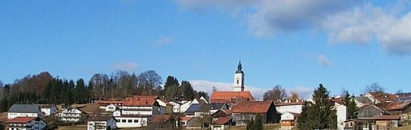
Schönberg
- municipality in the district of Freyung-Grafenau in Bavaria in Germany
Hiking in Schönberg
Schönberg, located in Lower Bavaria, is a picturesque area known for its stunning natural landscapes and hiking opportunities. Here are some key features of hiking in this region:...
- Country:
- Postal Code: 94513
- Local Dialing Code: 08554
- Licence Plate Code: FRG
- Coordinates: 48° 50' 0" N, 13° 20' 0" E
- GPS tracks (wikiloc): [Link]
- AboveSeaLevel: 563 м m
- Area: 32.75 sq km
- Population: 3663
- Web site: [Link]


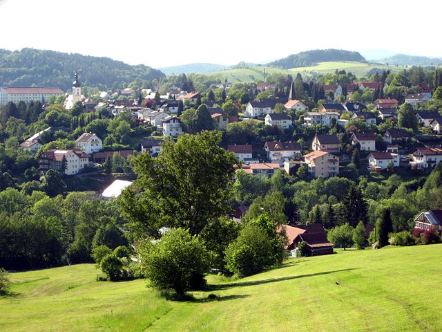
Frauenau
- municipality of Germany
Hiking in Frauenau
Frauenau is a picturesque village located in the Bavarian Forest in Germany, known for its beautiful landscapes and numerous hiking trails. The region is characterized by dense forests, rolling hills, and stunning views, making it a perfect destination for outdoor enthusiasts....
- Country:
- Postal Code: 94258
- Local Dialing Code: 09926
- Licence Plate Code: REG
- Coordinates: 48° 59' 0" N, 13° 18' 0" E
- GPS tracks (wikiloc): [Link]
- AboveSeaLevel: 616 м m
- Area: 60.1 sq km
- Population: 2697
- Web site: [Link]

Kirchdorf im Wald
- municipality of Germany
Hiking in Kirchdorf im Wald
Kirchdorf im Wald is a charming village located in the Bavarian region of Germany, known for its beautiful natural landscapes and outdoor activities, particularly hiking. The area offers a variety of hiking trails suitable for different skill levels, making it a great destination for both novice and experienced hikers....
- Country:
- Postal Code: 94261
- Local Dialing Code: 09928
- Licence Plate Code: REG
- Coordinates: 48° 55' 0" N, 13° 16' 0" E
- GPS tracks (wikiloc): [Link]
- AboveSeaLevel: 684 м m
- Area: 30.55 sq km
- Population: 2054
- Web site: [Link]


Eppenschlag
- municipality of Germany
Hiking in Eppenschlag
Eppenschlag is a charming town located in the Bavaria region of Germany, surrounded by beautiful landscapes that offer a variety of hiking opportunities. Here are some highlights and tips for hiking in and around Eppenschlag:...
- Country:
- Postal Code: 94536
- Local Dialing Code: 09928
- Licence Plate Code: FRG
- Coordinates: 48° 53' 0" N, 13° 18' 0" E
- GPS tracks (wikiloc): [Link]
- AboveSeaLevel: 608 м m
- Area: 17.03 sq km
- Population: 890
- Web site: [Link]


Sankt Oswald-Riedlhütte
- municipality of Germany
Hiking in Sankt Oswald-Riedlhütte
Sankt Oswald-Riedlhütte, located in the Bavarian Forest National Park in Germany, is a fantastic destination for hiking enthusiasts. The area is known for its stunning landscapes, diverse flora and fauna, and well-maintained trail systems. Here are some highlights and tips for hiking in this region:...
- Country:
- Postal Code: 94568; 94566
- Local Dialing Code: 08553
- Licence Plate Code: FRG
- Coordinates: 48° 53' 0" N, 13° 25' 0" E
- GPS tracks (wikiloc): [Link]
- AboveSeaLevel: 791 м m
- Area: 40.34 sq km
- Population: 3103
- Web site: [Link]

Grafenau
- municipality in Bavaria, Germany
Hiking in Grafenau
Grafenau, located in the Lower Bavarian region of Germany, is a delightful destination for hiking enthusiasts. It is surrounded by stunning natural landscapes, including the Bavarian Forest National Park, which provides a variety of trails suitable for all skill levels....
- Country:
- Postal Code: 94568; 94481
- Local Dialing Code: 08552
- Coordinates: 48° 51' 22" N, 13° 23' 49" E
- GPS tracks (wikiloc): [Link]
- AboveSeaLevel: 609 м m
- Area: 63.73 sq km
- Population: 8093
- Web site: [Link]