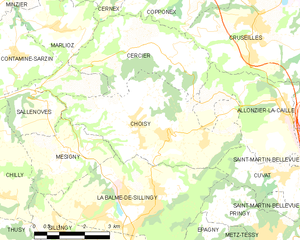
La Balme-de-Sillingy (La Balme-de-Sillingy)

- commune in Haute-Savoie, France
 Hiking in La Balme-de-Sillingy
La Balme-de-Sillingy, located in the Haute-Savoie region of France, offers some lovely hiking opportunities amidst beautiful Alpine scenery. The area is characterized by rolling hills, lush forests, and stunning views of the surrounding mountains, making it a delightful spot for both casual walkers and more experienced hikers.
Popular Hiking Trails:
-
Trail to Mont Sion:
- This trail offers an accessible hike with scenic views of the surrounding countryside. The path is well-marked and features gentle gradients, making it suitable for families and beginner hikers.
-
Les Crêts Trail:
- A moderate hike that leads you through mixed woodlands and offers panoramic views. This is perfect for those looking to connect with nature while enjoying a bit of a challenge.
-
Le Circuit des Praz:
- A loop trail that showcases the diverse flora and fauna of the region. This hike is a great way to explore the natural beauty of La Balme-de-Sillingy and can be enjoyed at a leisurely pace.
General Tips:
- Prepare for Weather: The weather can change quickly in the mountains, so always check forecasts beforehand and dress in layers.
- Stay Hydrated: Bring plenty of water, especially on warmer days.
- Trail Maps: Ensure you have a good map or a GPS device; while trails are usually marked, navigation can sometimes be tricky in rural areas.
- Respect Nature: Stay on marked trails and follow local guidelines to preserve the natural environment.
Local Amenities:
While La Balme-de-Sillingy is a small commune, there are typically amenities nearby, such as local shops, restaurants, and accommodations, where hikers can rest and recharge after their adventures.
Best Time to Visit:
The best times to hike in La Balme-de-Sillingy are during the spring and autumn months when the weather is generally mild, and the landscapes are particularly beautiful with blooming wildflowers or autumn foliage.
Whether you're looking for a peaceful day hike or something more strenuous, La Balme-de-Sillingy has something to offer for everyone who enjoys the outdoors.
- Country:

- Postal Code: 74330
- Coordinates: 45° 57' 40" N, 6° 2' 31" E


- GPS tracks (wikiloc): [Link]
- Area: 16.51 sq km
- Population: 5027
- Wikipedia en: wiki(en)
- Wikipedia: wiki(fr)
- Wikidata storage: Wikidata: Q735350
- Wikipedia Commons Category: [Link]
- Freebase ID: [/m/03ntxts]
- GeoNames ID: Alt: [6457071]
- SIREN number: [217400266]
- BnF ID: [15274286q]
- VIAF ID: Alt: [131548127]
- Library of Congress authority ID: Alt: [n91044363]
- Quora topic ID: [La-Balme-De-Sillingy]
- INSEE municipality code: 74026
Shares border with regions:

Choisy, Haute-Savoie
- commune in Haute-Savoie, France
Hiking in Choisy, Haute-Savoie
Choisy, located in the Haute-Savoie department in the Auvergne-Rhône-Alpes region of France, offers stunning hiking opportunities amid the picturesque landscapes of the French Alps. Here are some highlights and tips for hiking in Choisy:...
- Country:
- Postal Code: 74330
- Coordinates: 45° 59' 34" N, 6° 3' 27" E
- GPS tracks (wikiloc): [Link]
- Area: 16.57 sq km
- Population: 1558
- Web site: [Link]


Pringy, Haute-Savoie
- former commune in Haute-Savoie, France
Hiking in Pringy, Haute-Savoie
Pringy, located in the Haute-Savoie region of France, offers beautiful hiking opportunities that allow you to immerse yourself in the stunning Alpine landscape. The area is characterized by its picturesque scenery, including the backdrop of Mont Blanc and rolling hills, charming villages, and lush green forests....
- Country:
- Postal Code: 74370
- Coordinates: 45° 56' 48" N, 6° 7' 19" E
- GPS tracks (wikiloc): [Link]
- Area: 9.06 sq km
- Population: 4063
- Web site: [Link]


Cuvat
- commune in Haute-Savoie, France
Hiking in Cuvat
Cuvat is not widely recognized as a prominent hiking destination, as it might be a less-known locale or a misspelling of a more popular region. However, if you are referring to a specific area or a different name, please provide more context....
- Country:
- Postal Code: 74350
- Coordinates: 45° 58' 39" N, 6° 7' 8" E
- GPS tracks (wikiloc): [Link]
- Area: 4.72 sq km
- Population: 1213
- Web site: [Link]

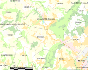
Sillingy
- commune in Haute-Savoie, France
Hiking in Sillingy
Sillingy, located in the Haute-Savoie region of France, offers a variety of hiking opportunities for outdoor enthusiasts. Nestled near the picturesque Annecy and surrounded by the stunning Alps, Sillingy provides breathtaking views and a range of trails suitable for different skill levels....
- Country:
- Postal Code: 74330
- Coordinates: 45° 56' 45" N, 6° 2' 7" E
- GPS tracks (wikiloc): [Link]
- Area: 14.84 sq km
- Population: 5045
- Web site: [Link]

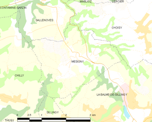
Mésigny
- commune in Haute-Savoie, France
Hiking in Mésigny
Mésigny, a charming village located in the Auvergne-Rhône-Alpes region of France, offers a variety of hiking opportunities that showcase the region's natural beauty. While the village itself is small, the surrounding area features beautiful landscapes, rolling hills, and scenic views that are perfect for outdoor enthusiasts....
- Country:
- Postal Code: 74330
- Coordinates: 45° 59' 8" N, 6° 0' 10" E
- GPS tracks (wikiloc): [Link]
- Area: 6.73 sq km
- Population: 689
- Web site: [Link]