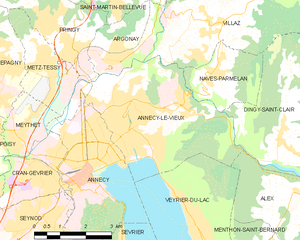
Pringy, Haute-Savoie (Pringy)

- former commune in Haute-Savoie, France
 Hiking in Pringy, Haute-Savoie
Pringy, located in the Haute-Savoie region of France, offers beautiful hiking opportunities that allow you to immerse yourself in the stunning Alpine landscape. The area is characterized by its picturesque scenery, including the backdrop of Mont Blanc and rolling hills, charming villages, and lush green forests.
Hiking Trails
-
Les Monts de Genève: This series of trails offers various difficulties and lengths. You can choose paths that wind through forests, pastures, and offer views of the surrounding mountains and Lake Geneva.
-
Mollard de Pringy: A popular hiking destination in the area, this route provides a moderate challenge and is ideal for families and casual hikers. The trail highlights the region's rich flora and fauna.
-
Gorges du Fier: A short drive from Pringy, this stunning gorge offers a spectacular trail that runs alongside the river. It's a great option if you're looking to combine an easy hike with picturesque views of rugged rock formations.
Tips for Hiking in Pringy
- Gear Up Properly: Make sure you're dressed in layers, wear sturdy hiking boots, and pack enough water and snacks.
- Check the Weather: The weather in the Alps can be unpredictable, so be sure to check the forecast before heading out.
- Maps and Signage: Take a map or download hiking apps that provide GPS navigation. Many trails are marked, but it’s always good to have a backup.
- Respect Nature: Stick to marked paths to protect the local ecosystem and wildlife.
Local Attractions
- Château de Montrottier: Not far from Pringy, this historical castle offers both stunning architecture and fascinating history.
- Annecy: A short drive away, this stunning town is known for its beautiful lake and charming canals, perfect for a relaxing day after hiking.
Accessibility
Pringy is accessible from major cities via the A41 motorway and is well-connected by public transport. The trails can vary in difficulty, making them suitable for a range of abilities, from leisurely strolls to more challenging hikes.
Enjoy your hiking adventure in Pringy, and take in the breathtaking views that this region has to offer!
- Country:

- Postal Code: 74370
- Coordinates: 45° 56' 48" N, 6° 7' 19" E


- GPS tracks (wikiloc): [Link]
- Area: 9.06 sq km
- Population: 4063
- Web site: http://www.pringy74.fr
- Wikipedia en: wiki(en)
- Wikipedia: wiki(fr)
- Wikidata storage: Wikidata: Q680266
- Wikipedia Commons Category: [Link]
- Freebase ID: [/m/03x_x41]
- GeoNames ID: Alt: [6443026]
- BnF ID: [15274473x]
- VIAF ID: Alt: [295352650]
- Library of Congress authority ID: Alt: [no2012161933]
- PACTOLS thesaurus ID: [pcrtsnmkSwN4IS]
- INSEE municipality code: 74217
Shares border with regions:

Annecy-le-Vieux
- former commune in Haute-Savoie, France
Hiking in Annecy-le-Vieux
Annecy-le-Vieux, located near the picturesque town of Annecy in the French Alps, offers a beautiful setting for hiking enthusiasts. This area is known for its stunning landscapes, crystal-clear Lake Annecy, and the surrounding mountains....
- Country:
- Postal Code: 74940
- Coordinates: 45° 55' 9" N, 6° 8' 31" E
- GPS tracks (wikiloc): [Link]
- Area: 17.01 sq km
- Population: 19990
- Web site: [Link]

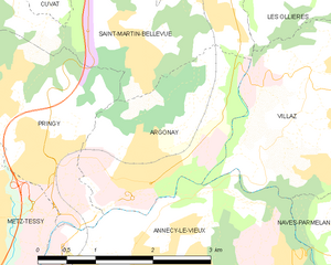
Argonay
- commune in Haute-Savoie, France
Hiking in Argonay
Argonay is a picturesque commune located in the Haute-Savoie department of France, near Annecy. The area offers a variety of outdoor activities, including hiking, thanks to its beautiful landscapes and proximity to the French Alps....
- Country:
- Postal Code: 74370
- Coordinates: 45° 56' 43" N, 6° 8' 25" E
- GPS tracks (wikiloc): [Link]
- Area: 5.16 sq km
- Population: 2734
- Web site: [Link]


Cuvat
- commune in Haute-Savoie, France
Hiking in Cuvat
Cuvat is not widely recognized as a prominent hiking destination, as it might be a less-known locale or a misspelling of a more popular region. However, if you are referring to a specific area or a different name, please provide more context....
- Country:
- Postal Code: 74350
- Coordinates: 45° 58' 39" N, 6° 7' 8" E
- GPS tracks (wikiloc): [Link]
- Area: 4.72 sq km
- Population: 1213
- Web site: [Link]

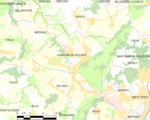
La Balme-de-Sillingy
- commune in Haute-Savoie, France
Hiking in La Balme-de-Sillingy
La Balme-de-Sillingy, located in the Haute-Savoie region of France, offers some lovely hiking opportunities amidst beautiful Alpine scenery. The area is characterized by rolling hills, lush forests, and stunning views of the surrounding mountains, making it a delightful spot for both casual walkers and more experienced hikers....
- Country:
- Postal Code: 74330
- Coordinates: 45° 57' 40" N, 6° 2' 31" E
- GPS tracks (wikiloc): [Link]
- Area: 16.51 sq km
- Population: 5027


Saint-Martin-Bellevue
- former commune in Haute-Savoie, France
Hiking in Saint-Martin-Bellevue
Saint-Martin-Bellevue is a charming commune located in the Haute-Savoie department in the Auvergne-Rhône-Alpes region of southeastern France. It is nestled near the foothills of the Alps, making it an excellent starting point for various hiking adventures. Here’s what you can expect when hiking in and around this picturesque area:...
- Country:
- Postal Code: 74370
- Coordinates: 45° 57' 44" N, 6° 8' 55" E
- GPS tracks (wikiloc): [Link]
- Area: 9.33 sq km
- Population: 2646
- Web site: [Link]


Metz-Tessy
- former commune in Haute-Savoie, France
Hiking in Metz-Tessy
Metz-Tessy is a charming village located in the Auvergne-Rhône-Alpes region of France, not far from the larger city of Annecy. The area is known for its stunning natural scenery, making it a fantastic destination for hiking aficionados....
- Country:
- Postal Code: 74370
- Coordinates: 45° 56' 26" N, 6° 6' 23" E
- GPS tracks (wikiloc): [Link]
- Area: 5.29 sq km
- Population: 3051