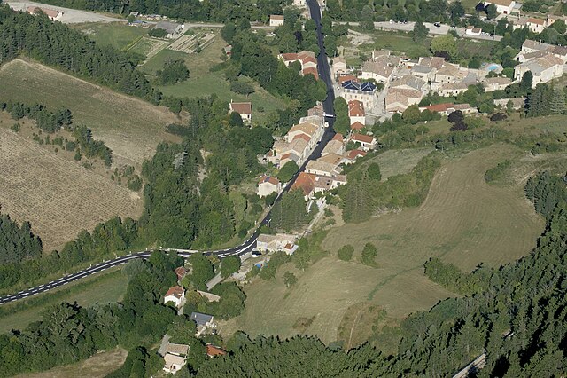
La Beaume (La Beaume)
- commune in Hautes-Alpes, France
 Hiking in La Beaume
La Beaume is a beautiful destination for hiking, typically known for its stunning landscapes, rich biodiversity, and scenic trails. Located in the region of Provence-Alpes-Côte d'Azur in France, it offers various trails suitable for different fitness levels and interests.
Key Highlights:
-
Scenic Trails: The area features trails that pass through diverse terrains, including forests, rocky outcrops, and river valleys. You can expect to see picturesque views of the surrounding countryside, especially during sunrise and sunset.
-
Difficulty Levels: Hikes in La Beaume vary from easy walks suitable for beginners to more challenging routes for experienced hikers. Always check trail markers and local maps to choose the right trail for your skill level.
-
Flora and Fauna: The region is home to a variety of plant species and wildlife. Nature lovers often enjoy bird watching and may encounter various species of flora specific to the Mediterranean climate.
-
Cultural Sites: Some trails may lead you to historical or cultural sites, such as ancient ruins or charming villages, adding an enriching experience to your hike.
-
Weather Conditions: Be sure to check weather conditions before your hike, as they can change rapidly, especially in mountainous areas. Spring and fall are generally ideal times for hiking due to mild temperatures.
-
Safety Tips: Always carry plenty of water, wear appropriate footwear, and let someone know your plans before heading out. It’s also wise to have a map or GPS device to navigate the trails effectively.
-
Local Regulations: Familiarize yourself with any local regulations or guidelines regarding hiking in the area. This can include information about permissible trails, camping, and wildlife protection.
Before you embark on your hiking adventure in La Beaume, it's a good idea to research specific trails, check visitor centers for maps, and inquire about guided hikes if you're looking for more information or safety assurance. Enjoy your hiking experience!
- Country:

- Postal Code: 05140
- Coordinates: 44° 33' 9" N, 5° 38' 12" E


- GPS tracks (wikiloc): [Link]
- Area: 29.64 sq km
- Population: 155
- Web site: http://05019.campagnol.fr
- Wikipedia en: wiki(en)
- Wikipedia: wiki(fr)
- Wikidata storage: Wikidata: Q471524
- Wikipedia Commons Category: [Link]
- Freebase ID: [/m/03mfm3h]
- Freebase ID: [/m/03mfm3h]
- GeoNames ID: Alt: [6456659]
- GeoNames ID: Alt: [6456659]
- SIREN number: [210500195]
- SIREN number: [210500195]
- INSEE municipality code: 05019
- INSEE municipality code: 05019
Shares border with regions:
Les Prés
- commune in Drôme, France
Hiking in Les Prés
Les Prés is a picturesque area that offers a beautiful hiking experience, often characterized by serene landscapes, diverse wildlife, and well-marked trails. Here are some key points about hiking in Les Prés:...
- Country:
- Postal Code: 26310
- Coordinates: 44° 31' 39" N, 5° 34' 45" E
- GPS tracks (wikiloc): [Link]
- Area: 16.6 sq km
- Population: 21
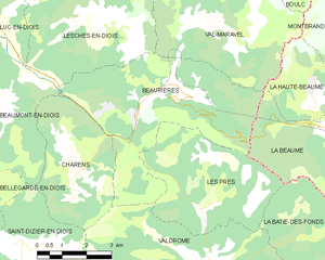
Beaurières
- commune in Drôme, France
Hiking in Beaurières
Beaurières is a beautiful destination located in the French Alps, known for its picturesque landscapes and diverse hiking opportunities. Set within the Drôme department, it offers hikers a chance to immerse themselves in nature, with stunning mountain views, serene lakes, and an abundance of flora and fauna....
- Country:
- Postal Code: 26310
- Coordinates: 44° 34' 18" N, 5° 33' 34" E
- GPS tracks (wikiloc): [Link]
- Area: 24.58 sq km
- Population: 80
Val-Maravel
- commune in Drôme, France
Hiking in Val-Maravel
Val-Maravel is known for its stunning landscapes and diverse ecosystems, making it a fantastic destination for hikers of all skill levels. The area typically features a mix of lush valleys, rugged mountains, and serene lakes, providing a variety of trails that cater to different experiences—from leisurely strolls to challenging climbs....
- Country:
- Postal Code: 26310
- Coordinates: 44° 35' 30" N, 5° 34' 11" E
- GPS tracks (wikiloc): [Link]
- Area: 21.6 sq km
- Population: 56


La Bâtie-des-Fonds
- commune in Drôme, France
Hiking in La Bâtie-des-Fonds
La Bâtie-des-Fonds, located in the Jura Mountains of Switzerland, is an excellent destination for hiking enthusiasts. The region is known for its stunning natural beauty, with rolling hills, dense forests, and picturesque landscapes. Here are some highlights about hiking in this area:...
- Country:
- Postal Code: 26310
- Coordinates: 44° 30' 52" N, 5° 38' 19" E
- GPS tracks (wikiloc): [Link]
- Area: 12.12 sq km
- Population: 6
Montbrand
- commune in Hautes-Alpes, France
Hiking in Montbrand
Montbrand is a charming area in the French Alps, known for its serene natural landscapes and opportunities for outdoor enthusiasts, particularly hikers. While specific trails and conditions may vary, here are some general insights into hiking in Montbrand:...
- Country:
- Postal Code: 05140
- Coordinates: 44° 35' 23" N, 5° 40' 57" E
- GPS tracks (wikiloc): [Link]
- Area: 25.03 sq km
- Population: 65


Saint-Pierre-d'Argençon
- commune in Hautes-Alpes, France
Hiking in Saint-Pierre-d'Argençon
Saint-Pierre-d'Argençon is a beautiful village located in the Hautes-Alpes region of southeastern France. It is surrounded by stunning natural scenery, making it a great destination for hiking enthusiasts. Here are some details about hiking in this area:...
- Country:
- Postal Code: 05140
- Coordinates: 44° 31' 12" N, 5° 41' 54" E
- GPS tracks (wikiloc): [Link]
- Area: 18.81 sq km
- Population: 157


La Faurie
- commune in Hautes-Alpes, France
Hiking in La Faurie
La Faurie is a picturesque village located in the Département of Hautes-Alpes in southeastern France, within the Provence-Alpes-Côte d'Azur region. The surrounding landscape offers stunning views and a variety of hiking opportunities suitable for different skill levels....
- Country:
- Postal Code: 05140
- Coordinates: 44° 34' 2" N, 5° 44' 24" E
- GPS tracks (wikiloc): [Link]
- Area: 31.44 sq km
- Population: 315
La Haute-Beaume
- commune in Hautes-Alpes, France
Hiking in La Haute-Beaume
La Haute-Beaume, located in the Auvergne region of France, offers a variety of hiking opportunities amid stunning natural landscapes. The area is characterized by rolling hills, lush forests, and picturesque valleys, making it a perfect destination for both novice and experienced hikers....
- Country:
- Postal Code: 05140
- Coordinates: 44° 33' 50" N, 5° 37' 40" E
- GPS tracks (wikiloc): [Link]
- AboveSeaLevel: 1100 м m
- Area: 7.13 sq km
- Population: 9