La Boissière-du-Doré (La Boissière-du-Doré)

- commune in Loire-Atlantique, France
- Country:

- Postal Code: 44430
- Coordinates: 47° 13' 55" N, 1° 13' 12" E


- GPS tracks (wikiloc): [Link]
- AboveSeaLevel: 80 м m
- Area: 9.41 sq km
- Population: 1038
- Web site: http://www.cc-vallet.fr/index.php?id=3984
- Wikipedia en: wiki(en)
- Wikipedia: wiki(fr)
- Wikidata storage: Wikidata: Q749960
- Wikipedia Commons Category: [Link]
- Freebase ID: [/m/03nwc7p]
- Freebase ID: [/m/03nwc7p]
- GeoNames ID: Alt: [6616806]
- GeoNames ID: Alt: [6616806]
- SIREN number: [214400160]
- SIREN number: [214400160]
- INSEE municipality code: 44016
- INSEE municipality code: 44016
Shares border with regions:

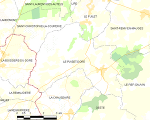
Le Puiset-Doré
- former commune in Maine-et-Loire, France
- Country:
- Postal Code: 49600
- Coordinates: 47° 13' 56" N, 1° 6' 56" E
- GPS tracks (wikiloc): [Link]
- Area: 22.62 sq km
- Population: 1175
- Web site: [Link]
Landemont
- former commune in Maine-et-Loire, France
- Country:
- Postal Code: 49270
- Coordinates: 47° 15' 54" N, 1° 14' 32" E
- GPS tracks (wikiloc): [Link]
- Area: 18.67 sq km
- Population: 1774


La Remaudière
- commune in Loire-Atlantique, France
- Country:
- Postal Code: 44430
- Coordinates: 47° 14' 15" N, 1° 14' 36" E
- GPS tracks (wikiloc): [Link]
- Area: 12.98 sq km
- Population: 1276
- Web site: [Link]

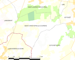
Saint-Christophe-la-Couperie
- former commune in Maine-et-Loire, France
- Country:
- Postal Code: 49270
- Coordinates: 47° 15' 11" N, 1° 10' 52" E
- GPS tracks (wikiloc): [Link]
- AboveSeaLevel: 104 м m
- Area: 8.29 sq km
- Population: 824