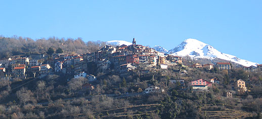
La Bollène-Vésubie (La Bollène-Vésubie)

- commune in Alpes-Maritimes, France
 Hiking in La Bollène-Vésubie
La Bollène-Vésubie is a charming village located in the Alpes-Maritimes department in the Provence-Alpes-Côte d'Azur region of France. It offers access to beautiful hiking trails that showcase the stunning landscapes of the French Alps. Here are some highlights for hikers considering this area:
Scenic Trails
-
Vésubie Valley Trails: The area around La Bollène-Vésubie is rich in trails that traverse the Vésubie Valley. You can enjoy picturesque views of the surrounding mountains, forests, and the Vésubie River.
-
Mediterranean and Alpine Flora: As you hike, you'll encounter a diverse range of flora and fauna, including Mediterranean and alpine species, offering plenty of opportunities for nature observation and photography.
-
Peïra Cava: This hike leads to the stunning plateau of Peïra Cava, where you can catch breathtaking views of the surrounding peaks and valleys. This trail is of moderate difficulty and rewards hikers with expansive vistas.
-
Cime de la Lausson: For avid hikers seeking a challenge, the ascent to Cime de la Lausson provides a strenuous yet rewarding trek. Once at the summit, hikers are treated to spectacular panoramic views.
Tips for Hiking in La Bollène-Vésubie
- Weather Considerations: The weather can change rapidly in the mountains, so it's essential to check the forecast and dress in layers.
- Trail Conditions: Some trails may have varying conditions, especially after rainfall or snowmelt. It's a good idea to check local guides or visitor centers for current trail conditions.
- Safety Precautions: Carry plenty of water, snacks, and a first aid kit. Inform someone of your hiking plans and expected return time.
- Wildlife Awareness: Keep an eye out for local wildlife, and remember to respect their habitats by not disturbing them.
Local Attractions
Beyond hiking, La Bollène-Vésubie itself offers cultural sites and local cuisine to explore. You might want to visit traditional architecture, experience the local markets, or enjoy a meal at a nearby restaurant.
Conclusion
Hiking in La Bollène-Vésubie is a fantastic way to experience the natural beauty of the French Alps while enjoying the tranquility of the rural landscape. Whether you're looking for an easy stroll or a challenging trek, you’ll find something that suits your ability and interests. Happy hiking!
- Country:

- Postal Code: 06450
- Coordinates: 43° 59' 23" N, 7° 19' 51" E


- GPS tracks (wikiloc): [Link]
- Area: 35.57 sq km
- Population: 567
- Web site: http://www.labollenevesubie.fr
- Wikipedia en: wiki(en)
- Wikipedia: wiki(fr)
- Wikidata storage: Wikidata: Q369741
- Wikipedia Commons Category: [Link]
- GeoNames ID: Alt: [3010981]
- GeoNames ID: Alt: [3010981]
- SIREN number: [210600201]
- SIREN number: [210600201]
- INSEE municipality code: 06020
- INSEE municipality code: 06020
Shares border with regions:

Roquebillière
- commune in Alpes-Maritimes, France
Hiking in Roquebillière
Roquebillière is a charming village located in the Alpes-Maritimes department of the French Riviera, situated at the foot of the impressive Mercantour National Park. Hiking in and around Roquebillière offers a variety of trails with stunning views, diverse landscapes, and opportunities to encounter local flora and fauna....
- Country:
- Postal Code: 06450
- Coordinates: 44° 0' 40" N, 7° 18' 25" E
- GPS tracks (wikiloc): [Link]
- Area: 25.92 sq km
- Population: 1802
- Web site: [Link]


Breil-sur-Roya
- commune in Alpes-Maritimes, France
Hiking in Breil-sur-Roya
Breil-sur-Roya, located in the Alpes-Maritimes department of France, is a charming village that serves as a gateway to some beautiful hiking trails in the surrounding area. Nestled in the Roya Valley, it offers a mix of stunning natural landscapes, historical sites, and a chance to experience the local culture....
- Country:
- Postal Code: 06540
- Coordinates: 43° 56' 14" N, 7° 30' 52" E
- GPS tracks (wikiloc): [Link]
- AboveSeaLevel: 287 м m
- Area: 81.31 sq km
- Population: 2271
- Web site: [Link]


Lantosque
- commune in Alpes-Maritimes, France
Hiking in Lantosque
Lantosque is a charming commune located in the Alpes-Maritimes department in the Provence-Alpes-Côte d'Azur region of southeastern France. It offers a range of hiking opportunities set against the stunning backdrop of the French Alps and the nearby Mercantour National Park....
- Country:
- Postal Code: 06450
- Coordinates: 43° 58' 24" N, 7° 18' 45" E
- GPS tracks (wikiloc): [Link]
- Area: 44.76 sq km
- Population: 1314
- Web site: [Link]

Moulinet
- commune in Alpes-Maritimes, France
Hiking in Moulinet
Moulinet is a charming village located in the Alpes-Maritimes region of France, nestled in the foothills of the Alps and close to the stunning Mercantour National Park. The area is known for its beautiful landscapes, diverse flora and fauna, and numerous hiking trails suited for various skill levels. Here’s what you need to know about hiking in Moulinet:...
- Country:
- Postal Code: 06380
- Coordinates: 43° 56' 27" N, 7° 24' 46" E
- GPS tracks (wikiloc): [Link]
- Area: 41.07 sq km
- Population: 274
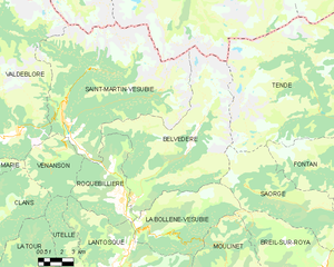
Belvédère
- commune in Alpes-Maritimes, France
Hiking in Belvédère
Belvédère is a beautiful hiking destination that is often characterized by stunning views and diverse landscapes. Although the specifics can depend on which "Belvédère" you are referring to, as the name can be found in different locations around the world, I'll provide an overview of what you typically might expect when hiking in areas known by this name....
- Country:
- Postal Code: 06450
- Coordinates: 44° 0' 53" N, 7° 19' 16" E
- GPS tracks (wikiloc): [Link]
- Area: 75.41 sq km
- Population: 660
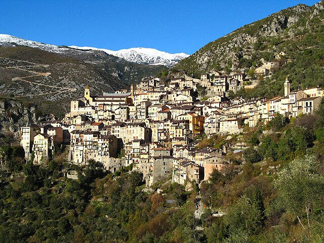

Saorge
- commune in Alpes-Maritimes, France
Hiking in Saorge
Saorge is a picturesque village located in the Alpes-Maritimes region of France, not far from the Italian border. The area is known for its stunning landscapes, charming architecture, and an array of hiking opportunities that cater to different skill levels. Here are some highlights and trails to consider when hiking in and around Saorge:...
- Country:
- Postal Code: 06540
- Coordinates: 43° 59' 14" N, 7° 33' 9" E
- GPS tracks (wikiloc): [Link]
- AboveSeaLevel: 513 м m
- Area: 86.78 sq km
- Population: 455
- Web site: [Link]