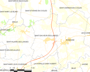
La Chapelle-Saint-Aubert (La Chapelle-Saint-Aubert)

- commune in Ille-et-Vilaine, France
- Country:

- Postal Code: 35140
- Coordinates: 48° 18' 49" N, 1° 18' 29" E


- GPS tracks (wikiloc): [Link]
- Area: 9.77 sq km
- Population: 425
- Wikipedia en: wiki(en)
- Wikipedia: wiki(fr)
- Wikidata storage: Wikidata: Q1063114
- Wikipedia Commons Category: [Link]
- Freebase ID: [/m/09xtsq]
- Freebase ID: [/m/09xtsq]
- GeoNames ID: Alt: [6456849]
- GeoNames ID: Alt: [6456849]
- SIREN number: [213500630]
- SIREN number: [213500630]
- BnF ID: [15257007b]
- BnF ID: [15257007b]
- VIAF ID: Alt: [157320213]
- VIAF ID: Alt: [157320213]
- OSM relation ID: [973229]
- OSM relation ID: [973229]
- Library of Congress authority ID: Alt: [n2006074196]
- Library of Congress authority ID: Alt: [n2006074196]
- PACTOLS thesaurus ID: [pcrtlE2SJrqN9w]
- PACTOLS thesaurus ID: [pcrtlE2SJrqN9w]
- MusicBrainz area ID: [98d50515-b4ce-46e4-a71a-520f03763ecd]
- MusicBrainz area ID: [98d50515-b4ce-46e4-a71a-520f03763ecd]
- INSEE municipality code: 35063
- INSEE municipality code: 35063
Shares border with regions:


Saint-Marc-sur-Couesnon
- commune in Ille-et-Vilaine, France
- Country:
- Postal Code: 35140
- Coordinates: 48° 18' 14" N, 1° 21' 56" E
- GPS tracks (wikiloc): [Link]
- Area: 12.05 sq km
- Population: 568
- Web site: [Link]

Romagné
- commune in Ille-et-Vilaine, France
- Country:
- Postal Code: 35133
- Coordinates: 48° 20' 32" N, 1° 16' 38" E
- GPS tracks (wikiloc): [Link]
- Area: 26.93 sq km
- Population: 2351
- Web site: [Link]


Vendel
- commune in Ille-et-Vilaine, France
- Country:
- Postal Code: 35140
- Coordinates: 48° 17' 57" N, 1° 18' 41" E
- GPS tracks (wikiloc): [Link]
- Area: 6.37 sq km
- Population: 388
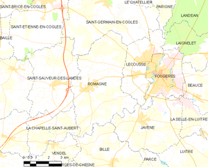
Saint-Sauveur-des-Landes
- commune in Ille-et-Vilaine, France
- Country:
- Postal Code: 35133
- Coordinates: 48° 20' 33" N, 1° 18' 49" E
- GPS tracks (wikiloc): [Link]
- Area: 18.84 sq km
- Population: 1513
- Web site: [Link]


Saint-Jean-sur-Couesnon
- commune in Ille-et-Vilaine, France
- Country:
- Postal Code: 35140
- Coordinates: 48° 17' 26" N, 1° 22' 2" E
- GPS tracks (wikiloc): [Link]
- Area: 18.32 sq km
- Population: 1149
- Web site: [Link]


Billé
- commune in Ille-et-Vilaine, France
- Country:
- Postal Code: 35133
- Coordinates: 48° 17' 16" N, 1° 14' 47" E
- GPS tracks (wikiloc): [Link]
- Area: 16.96 sq km
- Population: 1047
- Web site: [Link]