La Chapelle-Souëf (La Chapelle-Souëf)

- commune in Orne, France
- Country:

- Postal Code: 61130
- Coordinates: 48° 19' 24" N, 0° 35' 45" E


- GPS tracks (wikiloc): [Link]
- Area: 11.13 sq km
- Population: 265
- Wikipedia en: wiki(en)
- Wikipedia: wiki(fr)
- Wikidata storage: Wikidata: Q1095055
- Wikipedia Commons Category: [Link]
- Freebase ID: [/m/03qgrtc]
- Freebase ID: [/m/03qgrtc]
- GeoNames ID: Alt: [6457211]
- GeoNames ID: Alt: [6457211]
- SIREN number: [216100990]
- SIREN number: [216100990]
- BnF ID: [15268034p]
- BnF ID: [15268034p]
- MusicBrainz area ID: [c848d40d-c81e-4bb7-b9f2-321295234e60]
- MusicBrainz area ID: [c848d40d-c81e-4bb7-b9f2-321295234e60]
- INSEE municipality code: 61099
- INSEE municipality code: 61099
Shares border with regions:


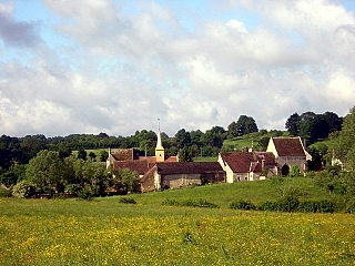
Gémages
- former commune in Orne, France
- Country:
- Postal Code: 61130
- Coordinates: 48° 17' 39" N, 0° 36' 56" E
- GPS tracks (wikiloc): [Link]
- Area: 6.47 sq km
- Population: 121

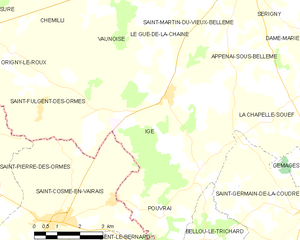
Igé
- commune in Orne, France
- Country:
- Postal Code: 61130
- Coordinates: 48° 19' 28" N, 0° 31' 17" E
- GPS tracks (wikiloc): [Link]
- Area: 27.86 sq km
- Population: 663


Saint-Cyr-la-Rosière
- commune in Orne, France
- Country:
- Postal Code: 61130
- Coordinates: 48° 19' 50" N, 0° 38' 25" E
- GPS tracks (wikiloc): [Link]
- Area: 18.75 sq km
- Population: 240


Saint-Germain-de-la-Coudre
- commune in Orne, France
- Country:
- Postal Code: 61130
- Coordinates: 48° 16' 50" N, 0° 36' 17" E
- GPS tracks (wikiloc): [Link]
- Area: 26.21 sq km
- Population: 772
- Web site: [Link]


Appenai-sous-Bellême
- commune in Orne, France
- Country:
- Postal Code: 61130
- Coordinates: 48° 20' 40" N, 0° 33' 29" E
- GPS tracks (wikiloc): [Link]
- Area: 10.74 sq km
- Population: 267

Dame-Marie
- commune in Orne, France
- Country:
- Postal Code: 61130
- Coordinates: 48° 21' 18" N, 0° 36' 55" E
- GPS tracks (wikiloc): [Link]
- Area: 13.27 sq km
- Population: 164