La Pallu (La Pallu)

- commune in Mayenne, France
- Country:

- Postal Code: 53140
- Coordinates: 48° 30' 28" N, 0° 17' 50" E


- GPS tracks (wikiloc): [Link]
- Area: 6.65 sq km
- Population: 193
- Wikipedia en: wiki(en)
- Wikipedia: wiki(fr)
- Wikidata storage: Wikidata: Q781154
- Wikipedia Commons Category: [Link]
- Freebase ID: [/m/03qddtm]
- GeoNames ID: Alt: [6456206]
- SIREN number: [215301730]
- BnF ID: [15263966k]
- INSEE municipality code: 53173
Shares border with regions:


Neuilly-le-Vendin
- commune in Mayenne, France
- Country:
- Postal Code: 53250
- Coordinates: 48° 29' 45" N, 0° 20' 21" E
- GPS tracks (wikiloc): [Link]
- Area: 14.6 sq km
- Population: 347
- Web site: [Link]

Saint-Calais-du-Désert
- commune in Mayenne, France
- Country:
- Postal Code: 53140
- Coordinates: 48° 29' 6" N, 0° 15' 41" E
- GPS tracks (wikiloc): [Link]
- Area: 17.2 sq km
- Population: 384

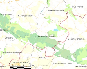
Saint-Patrice-du-Désert
- commune in Orne, France
- Country:
- Postal Code: 61600
- Coordinates: 48° 32' 31" N, 0° 18' 7" E
- GPS tracks (wikiloc): [Link]
- Area: 20.48 sq km
- Population: 202
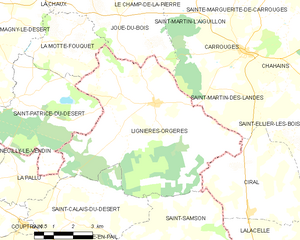
Lignières-Orgères
- commune in Mayenne, France
- Country:
- Postal Code: 53140
- Coordinates: 48° 32' 32" N, 0° 12' 25" E
- GPS tracks (wikiloc): [Link]
- AboveSeaLevel: 280 м m
- Area: 40.89 sq km
- Population: 778
- Web site: [Link]