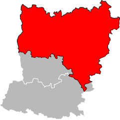
arrondissement of Mayenne (arrondissement de Mayenne)
- arrondissement of France
- Country:

- Capital: Mayenne
- Coordinates: 48° 20' 0" N, 0° 40' 0" E


- GPS tracks (wikiloc): [Link]
- Area: 2094 sq km
- Population: 121570
- Wikipedia en: wiki(en)
- Wikipedia: wiki(fr)
- Wikidata storage: Wikidata: Q701660
- Wikipedia Commons Category: [Link]
- Freebase ID: [/m/095f82]
- GeoNames ID: Alt: [2994933]
- INSEE arrondissement code: [533]
- GNS Unique Feature ID: -1450483
Includes regions:

canton of Ambrières-les-Vallées
- canton of France (until March 2015)
- Country:

- Capital: Ambrières-les-Vallées
- Coordinates: 48° 25' 6" N, 0° 38' 13" E


- GPS tracks (wikiloc): [Link]


canton of Ernée
- canton of France
- Country:

- Capital: Ernée
- Coordinates: 48° 19' 1" N, 0° 55' 41" E


- GPS tracks (wikiloc): [Link]
- Population: 21058


canton of Lassay-les-Châteaux
- canton of France
- Country:

- Capital: Lassay-les-Châteaux
- Coordinates: 48° 28' 27" N, 0° 28' 43" E


- GPS tracks (wikiloc): [Link]
- Population: 17869

canton of Pré-en-Pail
- canton of France
- Country:

- Capital: Pré-en-Pail
- Coordinates: 48° 26' 22" N, 0° 8' 45" E


- GPS tracks (wikiloc): [Link]


canton of Gorron
- canton of France
- Country:

- Capital: Gorron
- Coordinates: 48° 24' 32" N, 0° 49' 23" E


- GPS tracks (wikiloc): [Link]
- Population: 19317


canton of Villaines-la-Juhel
- canton of France
- Country:

- Capital: Villaines-la-Juhel
- Coordinates: 48° 19' 58" N, 0° 13' 53" E


- GPS tracks (wikiloc): [Link]
- Area: 548.05 sq km
- Population: 16519


