La Pouge (La Pouge)

- commune in Creuse, France
- Country:

- Postal Code: 23250
- Coordinates: 45° 58' 50" N, 1° 56' 42" E


- GPS tracks (wikiloc): [Link]
- Area: 7.58 sq km
- Population: 86
- Wikipedia en: wiki(en)
- Wikipedia: wiki(fr)
- Wikidata storage: Wikidata: Q583689
- Wikipedia Commons Category: [Link]
- Freebase ID: [/m/03mfk4h]
- Freebase ID: [/m/03mfk4h]
- GeoNames ID: Alt: [6455683]
- GeoNames ID: Alt: [6455683]
- SIREN number: [212315741]
- SIREN number: [212315741]
- BnF ID: [15251544g]
- BnF ID: [15251544g]
- INSEE municipality code: 23157
- INSEE municipality code: 23157
Shares border with regions:

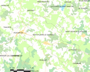
Saint-Hilaire-le-Château
- commune in Creuse, France
- Country:
- Postal Code: 23250
- Coordinates: 45° 58' 58" N, 1° 53' 49" E
- GPS tracks (wikiloc): [Link]
- Area: 19.59 sq km
- Population: 236


Saint-Georges-la-Pouge
- commune in Creuse, France
- Country:
- Postal Code: 23250
- Coordinates: 45° 59' 35" N, 1° 58' 13" E
- GPS tracks (wikiloc): [Link]
- Area: 24.09 sq km
- Population: 372
Vidaillat
- commune in Creuse, France
- Country:
- Postal Code: 23250
- Coordinates: 45° 57' 28" N, 1° 54' 25" E
- GPS tracks (wikiloc): [Link]
- Area: 23.59 sq km
- Population: 154

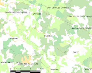
Chavanat
- commune in Creuse, France
- Country:
- Postal Code: 23250
- Coordinates: 45° 57' 11" N, 1° 57' 51" E
- GPS tracks (wikiloc): [Link]
- Area: 12.73 sq km
- Population: 138