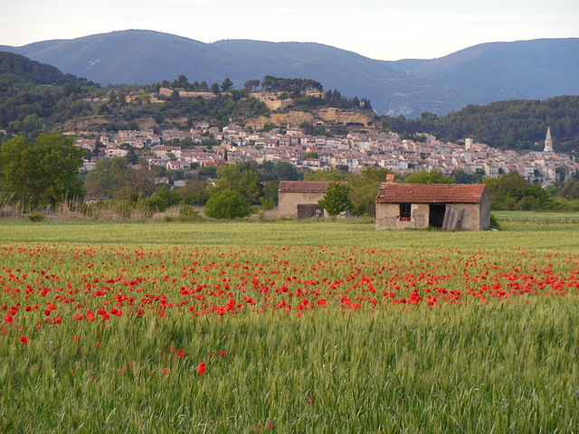
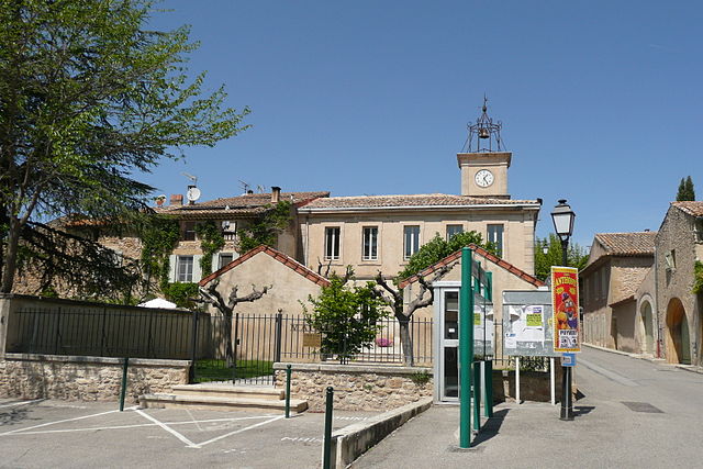
La Roque-d'Anthéron (La Roque-d'Anthéron)

- commune in Bouches-du-Rhône, France
 Hiking in La Roque-d'Anthéron
La Roque-d'Anthéron is a charming village located in the Provence-Alpes-Côte d'Azur region of France, nestled in the heart of the Luberon Valley. Known for its scenic landscapes, rich history, and vibrant flora and fauna, it's a great base for hikers looking to explore the beautiful terrain.
Hiking Trails
-
Sentier des Ocres: This trail takes you through stunning landscapes adorned with ochre cliffs and offers beautiful views of the surrounding countryside. It’s suitable for various skill levels.
-
The Luberon National Park: A short drive will take you into the national park, where you'll find a network of trails ranging from easy walks to challenging hikes, allowing you to experience the region's diverse ecosystems and panoramic views.
-
Le Sentier de la Sorgue: This is a picturesque path that follows the Sorgue River, offering cooler temperatures and relaxing scenery. It's particularly nice in warmer months and is great for families.
Points of Interest
-
The Sénanque Abbey: While not directly in La Roque-d'Anthéron, this nearby abbey is a worthwhile visit, especially for those interested in history. It is accessible via hiking trails that wind through scenic landscapes.
-
Local Flora and Fauna: The area is rich in biodiversity, so keep your eyes peeled for various plant species and wildlife. Birdwatching can also be quite rewarding.
Tips for Hiking in La Roque-d'Anthéron
-
Weather: Be mindful of the weather, especially during the summer months, as it can get quite hot. Carry plenty of water and wear appropriate gear.
-
Navigation: Many trails are marked, but having a map or GPS device can be helpful, especially if you plan to explore less-known paths.
-
Footwear: Good hiking shoes are recommended due to varying terrain conditions.
-
Respect Nature: As always, follow Leave No Trace principles to preserve the beautiful environment for future visitors.
Conclusion
La Roque-d'Anthéron offers a fantastic opportunity for hikers to immerse themselves in the beauty of Provence. Whether you're a seasoned hiker or looking for a leisurely stroll, the area provides a mix of experiences that showcase the rich cultural and natural heritage of the region. Happy hiking!
- Country:

- Postal Code: 13640
- Coordinates: 43° 42' 53" N, 5° 18' 39" E


- GPS tracks (wikiloc): [Link]
- Area: 25.49 sq km
- Population: 5469
- Web site: http://www.ville-la-roque-d-antheron.fr
- Wikipedia en: wiki(en)
- Wikipedia: wiki(fr)
- Wikidata storage: Wikidata: Q675868
- Wikipedia Commons Category: [Link]
- Freebase ID: [/m/02rpchf]
- GeoNames ID: Alt: [3006703]
- SIREN number: [211300843]
- BnF ID: [15247366g]
- VIAF ID: Alt: [299983829]
- archINFORM location ID: [5430]
- Library of Congress authority ID: Alt: [n2002014979]
- PACTOLS thesaurus ID: [pcrtoHLVD5LV2J]
- MusicBrainz area ID: [901ab6bb-1e82-4df0-9ee8-8ffd8c80a4ae]
- WOEID: [12663985]
- INSEE municipality code: 13084
Shares border with regions:

Cadenet
- commune in Vaucluse, France
Hiking in Cadenet
Cadenet, located in the Provence-Alpes-Côte d'Azur region of southeastern France, is a charming village that serves as a great starting point for hiking adventures in the surrounding Vaucluse and Luberon regions. Here are some noteworthy aspects of hiking in and around Cadenet:...
- Country:
- Postal Code: 84160
- Coordinates: 43° 44' 6" N, 5° 22' 24" E
- GPS tracks (wikiloc): [Link]
- AboveSeaLevel: 234 м m
- Area: 25.08 sq km
- Population: 4154
- Web site: [Link]


Charleval
- commune in Bouches-du-Rhône, France
Hiking in Charleval
Charleval, located in the Bouches-du-Rhône department in the south of France, offers beautiful hiking opportunities amidst stunning natural landscapes. Here are some key points about hiking in Charleval:...
- Country:
- Postal Code: 13350
- Coordinates: 43° 43' 7" N, 5° 14' 44" E
- GPS tracks (wikiloc): [Link]
- Area: 14.41 sq km
- Population: 2731
- Web site: [Link]

Puyvert
- commune in Vaucluse, France
Hiking in Puyvert
Puyvert, located in the Vaucluse region of Provence, France, is known for its picturesque landscapes and charming rural atmosphere. Although it's a small village, the surrounding area offers a variety of hiking opportunities that can cater to different skill levels....
- Country:
- Postal Code: 84160
- Coordinates: 43° 45' 33" N, 5° 20' 35" E
- GPS tracks (wikiloc): [Link]
- Area: 9.78 sq km
- Population: 819


Puget
- commune in Vaucluse, France
Hiking in Puget
Hiking in the Puget Sound region of Washington State offers an incredible variety of trails and stunning scenery, ranging from coastal walks to mountainous terrains. The region's diverse ecosystems provide opportunities to explore lush forests, alpine lakes, and vibrant wildlife. Here are some highlights:...
- Country:
- Postal Code: 84360
- Coordinates: 43° 45' 18" N, 5° 16' 9" E
- GPS tracks (wikiloc): [Link]
- Area: 17.9 sq km
- Population: 735


Lambesc
- commune in Bouches-du-Rhône, France
Hiking in Lambesc
Lambesc, a charming commune in the Bouches-du-Rhône department of southern France, offers a variety of hiking opportunities that showcase the stunning landscapes and rich cultural heritage of the region. Here are some highlights of hiking in and around Lambesc:...
- Country:
- Postal Code: 13410
- Coordinates: 43° 39' 14" N, 5° 15' 43" E
- GPS tracks (wikiloc): [Link]
- Area: 65.34 sq km
- Population: 9584
- Web site: [Link]


Lauris
- commune in Vaucluse, France
Hiking in Lauris
Lauris is a picturesque village located in the Provence-Alpes-Côte d'Azur region of France, known for its stunning landscapes, charming architecture, and rich history. It sits at the foot of the Luberon mountains, making it an excellent base for hikers looking to explore the natural beauty of the area. Here are some key points to consider when hiking in Lauris:...
- Country:
- Postal Code: 84360
- Coordinates: 43° 44' 49" N, 5° 18' 48" E
- GPS tracks (wikiloc): [Link]
- Area: 21.81 sq km
- Population: 3789
- Web site: [Link]


Rognes
- commune in Bouches-du-Rhône, France
Hiking in Rognes
Rognes, located in the Bouches-du-Rhône department in the south of France, is a charming village surrounded by the beautiful landscapes of Provence. Hiking in and around Rognes offers a fantastic experience for outdoor enthusiasts, thanks to its scenic trails and natural beauty....
- Country:
- Postal Code: 13840
- Coordinates: 43° 39' 52" N, 5° 20' 50" E
- GPS tracks (wikiloc): [Link]
- Area: 58.32 sq km
- Population: 4795


Saint-Estève-Janson
- commune in Bouches-du-Rhône, France
Hiking in Saint-Estève-Janson
Saint-Estève-Janson is a charming village located in the Bouches-du-Rhône department in the Provence-Alpes-Côte d'Azur region of southern France. The area is characterized by its beautiful landscapes, Mediterranean climate, and rich biodiversity, making it a delightful destination for hikers....
- Country:
- Postal Code: 13610
- Coordinates: 43° 41' 12" N, 5° 23' 39" E
- GPS tracks (wikiloc): [Link]
- Area: 8.65 sq km
- Population: 379