La Roussière (La Roussière)

- former commune in Eure, France
- Country:

- Postal Code: 27270
- Coordinates: 48° 57' 41" N, 0° 34' 48" E


- GPS tracks (wikiloc): [Link]
- Area: 10.23 sq km
- Population: 201
- Wikipedia en: wiki(en)
- Wikipedia: wiki(fr)
- Wikidata storage: Wikidata: Q286521
- Wikipedia Commons Category: [Link]
- Freebase ID: [/m/03nqlk3]
- Freebase ID: [/m/03nqlk3]
- GeoNames ID: Alt: [6615235]
- GeoNames ID: Alt: [6615235]
- INSEE municipality code: 27499
- INSEE municipality code: 27499
Shares border with regions:


Épinay
- former commune in Eure, France
- Country:
- Postal Code: 27330
- Coordinates: 48° 58' 52" N, 0° 38' 31" E
- GPS tracks (wikiloc): [Link]
- AboveSeaLevel: 193 м m
- Area: 13.54 sq km
- Population: 308


Gisay-la-Coudre
- former commune in Eure, France
- Country:
- Coordinates: 48° 57' 1" N, 0° 37' 34" E
- GPS tracks (wikiloc): [Link]
- AboveSeaLevel: 185 м m
- Area: 16.27 sq km
- Population: 240


Chamblac
- commune in Eure, France
- Country:
- Postal Code: 27270
- Coordinates: 48° 59' 18" N, 0° 32' 40" E
- GPS tracks (wikiloc): [Link]
- Area: 20.9 sq km
- Population: 390
Saint-Agnan-de-Cernières
- commune in Eure, France
- Country:
- Postal Code: 27390
- Coordinates: 48° 57' 12" N, 0° 31' 0" E
- GPS tracks (wikiloc): [Link]
- AboveSeaLevel: 160 м m
- Area: 7.42 sq km
- Population: 148

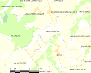
Landepéreuse
- former commune in Eure, France
- Country:
- Postal Code: 27410
- Coordinates: 49° 0' 16" N, 0° 38' 18" E
- GPS tracks (wikiloc): [Link]
- Area: 8.92 sq km
- Population: 383