Landepéreuse (Landepéreuse)

- former commune in Eure, France
- Country:

- Postal Code: 27410
- Coordinates: 49° 0' 16" N, 0° 38' 18" E


- GPS tracks (wikiloc): [Link]
- Area: 8.92 sq km
- Population: 383
- Wikipedia en: wiki(en)
- Wikipedia: wiki(fr)
- Wikidata storage: Wikidata: Q528427
- Wikipedia Commons Category: [Link]
- Freebase ID: [/m/03mhrfb]
- Freebase ID: [/m/03mhrfb]
- GeoNames ID: Alt: [3007877]
- GeoNames ID: Alt: [3007877]
- BnF ID: [15253597j]
- BnF ID: [15253597j]
- INSEE municipality code: 27362
- INSEE municipality code: 27362
Shares border with regions:


Épinay
- former commune in Eure, France
- Country:
- Postal Code: 27330
- Coordinates: 48° 58' 52" N, 0° 38' 31" E
- GPS tracks (wikiloc): [Link]
- AboveSeaLevel: 193 м m
- Area: 13.54 sq km
- Population: 308


Chamblac
- commune in Eure, France
- Country:
- Postal Code: 27270
- Coordinates: 48° 59' 18" N, 0° 32' 40" E
- GPS tracks (wikiloc): [Link]
- Area: 20.9 sq km
- Population: 390


Sainte-Marguerite-en-Ouche
- former commune in Eure, France
- Country:
- Postal Code: 27410
- Coordinates: 49° 1' 28" N, 0° 39' 28" E
- GPS tracks (wikiloc): [Link]
- Area: 5.35 sq km
- Population: 130

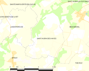
Saint-Aubin-des-Hayes
- former commune in Eure, France
- Country:
- Postal Code: 27410
- Coordinates: 49° 0' 33" N, 0° 40' 43" E
- GPS tracks (wikiloc): [Link]
- Area: 5.95 sq km
- Population: 167

La Roussière
- former commune in Eure, France
- Country:
- Postal Code: 27270
- Coordinates: 48° 57' 41" N, 0° 34' 48" E
- GPS tracks (wikiloc): [Link]
- Area: 10.23 sq km
- Population: 201


Jonquerets-de-Livet
- former commune in Eure, France
- Country:
- Postal Code: 27410
- Coordinates: 49° 1' 17" N, 0° 36' 29" E
- GPS tracks (wikiloc): [Link]
- Area: 10.28 sq km
- Population: 316