La Villetelle (La Villetelle)

- commune in Creuse, France
- Country:

- Postal Code: 23260
- Coordinates: 45° 55' 8" N, 2° 20' 28" E


- GPS tracks (wikiloc): [Link]
- Area: 16.14 sq km
- Population: 169
- Wikipedia en: wiki(en)
- Wikipedia: wiki(fr)
- Wikidata storage: Wikidata: Q1060847
- Wikipedia Commons Category: [Link]
- Freebase ID: [/m/03mflmv]
- Freebase ID: [/m/03mflmv]
- GeoNames ID: Alt: [6455688]
- GeoNames ID: Alt: [6455688]
- SIREN number: [212326607]
- SIREN number: [212326607]
- BnF ID: [15251652c]
- BnF ID: [15251652c]
- INSEE municipality code: 23266
- INSEE municipality code: 23266
Shares border with regions:
Saint-Silvain-Bellegarde
- commune in Creuse, France
- Country:
- Postal Code: 23190
- Coordinates: 45° 58' 21" N, 2° 18' 11" E
- GPS tracks (wikiloc): [Link]
- AboveSeaLevel: 550 м m
- Area: 20.85 sq km
- Population: 203
Mautes
- commune in Creuse, France
- Country:
- Postal Code: 23190
- Coordinates: 45° 56' 38" N, 2° 23' 4" E
- GPS tracks (wikiloc): [Link]
- Area: 22.67 sq km
- Population: 218


Saint-Pardoux-d'Arnet
- commune in Creuse, France
- Country:
- Postal Code: 23260
- Coordinates: 45° 52' 37" N, 2° 19' 50" E
- GPS tracks (wikiloc): [Link]
- Area: 16.44 sq km
- Population: 168
Saint-Oradoux-près-Crocq
- commune in Creuse, France
- Country:
- Postal Code: 23260
- Coordinates: 45° 52' 42" N, 2° 23' 17" E
- GPS tracks (wikiloc): [Link]
- Area: 13.36 sq km
- Population: 100

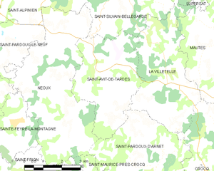
Saint-Avit-de-Tardes
- commune in Creuse, France
- Country:
- Postal Code: 23200
- Coordinates: 45° 55' 5" N, 2° 17' 7" E
- GPS tracks (wikiloc): [Link]
- Area: 14.42 sq km
- Population: 177
Lupersat
- commune in Creuse, France
- Country:
- Postal Code: 23190
- Coordinates: 45° 59' 7" N, 2° 21' 21" E
- GPS tracks (wikiloc): [Link]
- Area: 32.64 sq km
- Population: 321