Laborde (Laborde)

- commune in Hautes-Pyrénées, France
- Country:

- Postal Code: 65130
- Coordinates: 43° 1' 52" N, 0° 17' 43" E


- GPS tracks (wikiloc): [Link]
- Area: 1.82 sq km
- Population: 88
- Wikipedia en: wiki(en)
- Wikipedia: wiki(fr)
- Wikidata storage: Wikidata: Q842147
- Wikipedia Commons Category: [Link]
- Freebase ID: [/m/03w9m86]
- Freebase ID: [/m/03w9m86]
- GeoNames ID: Alt: [6440776]
- GeoNames ID: Alt: [6440776]
- SIREN number: [216502419]
- SIREN number: [216502419]
- BnF ID: [152706218]
- BnF ID: [152706218]
- INSEE municipality code: 65241
- INSEE municipality code: 65241
Shares border with regions:


Arrodets
- commune in Hautes-Pyrénées, France
- Country:
- Postal Code: 65130
- Coordinates: 43° 1' 49" N, 0° 17' 0" E
- GPS tracks (wikiloc): [Link]
- Area: 0.98 sq km
- Population: 23


Bulan
- commune in Hautes-Pyrénées, France
- Country:
- Postal Code: 65130
- Coordinates: 43° 2' 22" N, 0° 16' 42" E
- GPS tracks (wikiloc): [Link]
- Area: 3.41 sq km
- Population: 60

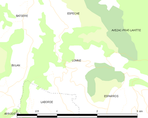
Lomné
- commune in Hautes-Pyrénées, France
- Country:
- Postal Code: 65130
- Coordinates: 43° 2' 45" N, 0° 17' 57" E
- GPS tracks (wikiloc): [Link]
- Area: 2.94 sq km
- Population: 32

Esparros
- commune in Hautes-Pyrénées, France
- Country:
- Postal Code: 65130
- Coordinates: 43° 1' 54" N, 0° 19' 16" E
- GPS tracks (wikiloc): [Link]
- Area: 32.56 sq km
- Population: 173
- Web site: [Link]