Laguépie (Laguépie)
- commune in Tarn-et-Garonne, France
- Country:

- Postal Code: 82250
- Coordinates: 44° 8' 40" N, 1° 58' 12" E


- GPS tracks (wikiloc): [Link]
- Area: 14.86 sq km
- Population: 635
- Web site: http://www.laguepie.fr
- Wikipedia en: wiki(en)
- Wikipedia: wiki(fr)
- Wikidata storage: Wikidata: Q1626789
- Wikipedia Commons Category: [Link]
- Freebase ID: [/m/03qg1j6]
- Freebase ID: [/m/03qg1j6]
- GeoNames ID: Alt: [6615254]
- GeoNames ID: Alt: [6615254]
- SIREN number: [218200889]
- SIREN number: [218200889]
- INSEE municipality code: 82088
- INSEE municipality code: 82088
Shares border with regions:


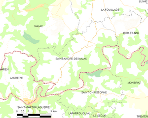
Saint-André-de-Najac
- commune in Aveyron, France
- Country:

- Postal Code: 12270
- Coordinates: 44° 11' 24" N, 2° 2' 25" E


- GPS tracks (wikiloc): [Link]
- Area: 25.1 sq km
- Population: 413
Le Riols
- commune in Tarn, France
- Country:

- Postal Code: 81170
- Coordinates: 44° 9' 5" N, 1° 54' 37" E


- GPS tracks (wikiloc): [Link]
- Area: 5.01 sq km
- Population: 107


Saint-Martin-Laguépie
- commune in Tarn, France
- Country:

- Postal Code: 81170
- Coordinates: 44° 8' 32" N, 1° 58' 25" E


- GPS tracks (wikiloc): [Link]
- Area: 21.51 sq km
- Population: 405


Varen
- commune in Tarn-et-Garonne, France
- Country:

- Postal Code: 82330
- Coordinates: 44° 9' 29" N, 1° 53' 39" E


- GPS tracks (wikiloc): [Link]
- Area: 23.13 sq km
- Population: 656
- Web site: [Link]


Najac
- commune in Aveyron, France
- Country:

- Postal Code: 12270
- Coordinates: 44° 13' 12" N, 1° 58' 45" E


- GPS tracks (wikiloc): [Link]
- Area: 53.88 sq km
- Population: 702
