Lamancine (Lamancine)

- commune in Haute-Marne, France
- Country:

- Postal Code: 52310
- Coordinates: 48° 12' 33" N, 5° 6' 57" E


- GPS tracks (wikiloc): [Link]
- Area: 4.48 sq km
- Population: 125
- Wikipedia en: wiki(en)
- Wikipedia: wiki(fr)
- Wikidata storage: Wikidata: Q1329709
- Wikipedia Commons Category: [Link]
- Freebase ID: [/m/03ntsjy]
- Freebase ID: [/m/03ntsjy]
- GeoNames ID: Alt: [6436216]
- GeoNames ID: Alt: [6436216]
- SIREN number: [215201872]
- SIREN number: [215201872]
- BnF ID: [15263507z]
- BnF ID: [15263507z]
- INSEE municipality code: 52260
- INSEE municipality code: 52260
Shares border with regions:

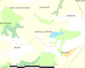
Annéville-la-Prairie
- commune in Haute-Marne, France
- Country:
- Postal Code: 52310
- Coordinates: 48° 11' 50" N, 5° 5' 2" E
- GPS tracks (wikiloc): [Link]
- Area: 5.22 sq km
- Population: 77
Oudincourt
- commune in Haute-Marne, France
- Country:
- Postal Code: 52310
- Coordinates: 48° 13' 31" N, 5° 5' 38" E
- GPS tracks (wikiloc): [Link]
- Area: 7.44 sq km
- Population: 146
Vraincourt
- commune in Haute-Marne, France
- Country:
- Postal Code: 52310
- Coordinates: 48° 14' 29" N, 5° 7' 29" E
- GPS tracks (wikiloc): [Link]
- Area: 3.48 sq km
- Population: 88


Bologne
- commune in Haute-Marne, France
- Country:
- Postal Code: 52310
- Coordinates: 48° 12' 7" N, 5° 8' 27" E
- GPS tracks (wikiloc): [Link]
- Area: 31.26 sq km
- Population: 1897