Lamotte-Warfusée (Lamotte-Warfusée)

- commune in Somme, France
- Country:

- Postal Code: 80800
- Coordinates: 49° 52' 17" N, 2° 35' 44" E


- GPS tracks (wikiloc): [Link]
- AboveSeaLevel: 77 м m
- Area: 9.36 sq km
- Population: 705
- Web site: http://www.lamottewarfusee.fr
- Wikipedia en: wiki(en)
- Wikipedia: wiki(fr)
- Wikidata storage: Wikidata: Q1246606
- Wikipedia Commons Category: [Link]
- Freebase ID: [/m/03qjzdb]
- GeoNames ID: Alt: [3008006]
- SIREN number: [218004414]
- BnF ID: [15276942h]
- Pleiades ID: [109453]
- INSEE municipality code: 80463
Shares border with regions:


Le Hamel
- commune in Somme, France
- Country:
- Postal Code: 80800
- Coordinates: 49° 53' 59" N, 2° 34' 13" E
- GPS tracks (wikiloc): [Link]
- Area: 9.12 sq km
- Population: 508


Marcelcave
- commune in Somme, France
- Country:
- Postal Code: 80720
- Coordinates: 49° 51' 0" N, 2° 34' 28" E
- GPS tracks (wikiloc): [Link]
- Area: 12.49 sq km
- Population: 1182
- Web site: [Link]


Bayonvillers
- commune in Somme, France
- Country:
- Postal Code: 80170
- Coordinates: 49° 51' 41" N, 2° 37' 37" E
- GPS tracks (wikiloc): [Link]
- Area: 8.1 sq km
- Population: 351

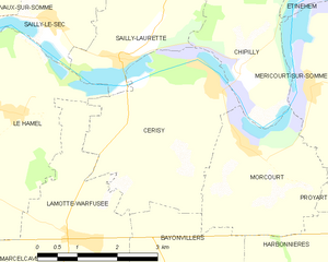
Cerisy
- commune in Somme, France
- Country:
- Postal Code: 80800
- Coordinates: 49° 54' 23" N, 2° 38' 19" E
- GPS tracks (wikiloc): [Link]
- AboveSeaLevel: 68 м m
- Area: 10.94 sq km
- Population: 520


Villers-Bretonneux
- commune in Somme, France
- Country:
- Postal Code: 80380
- Coordinates: 49° 52' 1" N, 2° 31' 12" E
- GPS tracks (wikiloc): [Link]
- Area: 14.51 sq km
- Population: 4387
- Web site: [Link]


Hamelet
- commune in Somme, France
- Country:
- Postal Code: 80800
- Coordinates: 49° 54' 19" N, 2° 31' 43" E
- GPS tracks (wikiloc): [Link]
- Area: 5.93 sq km
- Population: 622


Wiencourt-l'Équipée
- commune in Somme, France
- Country:
- Postal Code: 80170
- Coordinates: 49° 50' 43" N, 2° 36' 40" E
- GPS tracks (wikiloc): [Link]
- Area: 5.86 sq km
- Population: 259

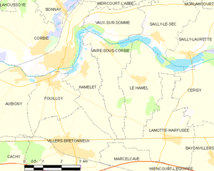
Vaire-sous-Corbie
- commune in Somme, France
- Country:
- Postal Code: 80800
- Coordinates: 49° 54' 58" N, 2° 32' 43" E
- GPS tracks (wikiloc): [Link]
- Area: 6.74 sq km
- Population: 281