Lançon-Provence (Lançon-Provence)

- commune in Bouches-du-Rhône, France
- Country:

- Postal Code: 13680
- Coordinates: 43° 35' 33" N, 5° 7' 41" E


- GPS tracks (wikiloc): [Link]
- Area: 68.92 sq km
- Population: 8811
- Web site: http://www.lancon-provence.fr
- Wikipedia en: wiki(en)
- Wikipedia: wiki(fr)
- Wikidata storage: Wikidata: Q428333
- Wikipedia Commons Category: [Link]
- Freebase ID: [/m/02rp8wx]
- GeoNames ID: Alt: [3007912]
- SIREN number: [211300512]
- BnF ID: [15247333h]
- VIAF ID: Alt: [123782241]
- PACTOLS thesaurus ID: [pcrt28ERkkryLp]
- MusicBrainz area ID: [7cf784c8-faa8-4c9e-8d7c-ec1d9b4d6ac3]
- SUDOC authorities ID: [067091873]
- INSEE municipality code: 13051
Shares border with regions:


Salon-de-Provence
- commune in Bouches-du-Rhône, France
- Country:
- Postal Code: 13300
- Coordinates: 43° 38' 26" N, 5° 5' 50" E
- GPS tracks (wikiloc): [Link]
- AboveSeaLevel: 94 м m
- Area: 70.3 sq km
- Population: 44836
- Web site: [Link]


Éguilles
- commune in Bouches-du-Rhône, France
 Hiking in Éguilles
Éguilles is a charming village located in the Provence-Alpes-Côte d'Azur region of southern France, close to the city of Aix-en-Provence. The area surrounding Éguilles offers a variety of hiking opportunities that allow you to explore the stunning landscapes, diverse flora and fauna, and the cultural heritage of the region....
- Country:
- Postal Code: 13510
- Coordinates: 43° 34' 7" N, 5° 21' 15" E
- GPS tracks (wikiloc): [Link]
- Area: 34.07 sq km
- Population: 7672
- Web site: [Link]


Berre-l'Étang
- commune in Bouches-du-Rhône, France
- Country:
- Postal Code: 13130
- Coordinates: 43° 28' 32" N, 5° 10' 5" E
- GPS tracks (wikiloc): [Link]
- Area: 43.64 sq km
- Population: 13477
- Web site: [Link]

La Barben
- commune in Bouches-du-Rhône, France
- Country:
- Postal Code: 13330
- Coordinates: 43° 37' 48" N, 5° 10' 35" E
- GPS tracks (wikiloc): [Link]
- Area: 22.85 sq km
- Population: 814

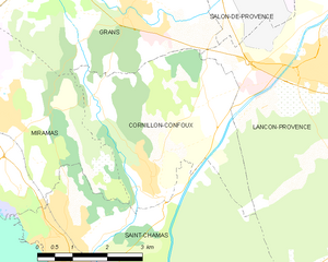
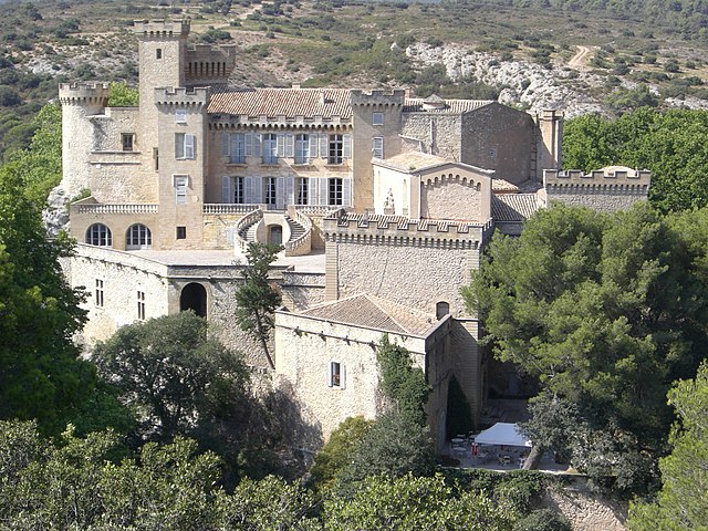
Cornillon-Confoux
- commune in Bouches-du-Rhône, France
- Country:
- Postal Code: 13250
- Coordinates: 43° 33' 45" N, 5° 4' 18" E
- GPS tracks (wikiloc): [Link]
- Area: 14.95 sq km
- Population: 1371
- Web site: [Link]


Pélissanne
- commune in Bouches-du-Rhône, France
- Country:
- Postal Code: 13330
- Coordinates: 43° 37' 53" N, 5° 9' 2" E
- GPS tracks (wikiloc): [Link]
- Area: 19.11 sq km
- Population: 10055
- Web site: [Link]

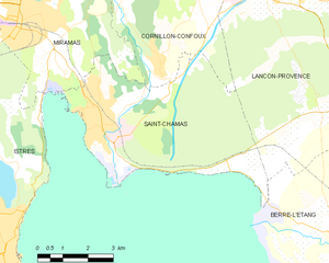
Saint-Chamas
- commune in Bouches-du-Rhône, France
- Country:
- Postal Code: 13250
- Coordinates: 43° 33' 1" N, 5° 2' 5" E
- GPS tracks (wikiloc): [Link]
- Area: 26.71 sq km
- Population: 8302
- Web site: [Link]

La Fare-les-Oliviers
- commune in Bouches-du-Rhône, France
- Country:
- Postal Code: 13580
- Coordinates: 43° 33' 6" N, 5° 11' 41" E
- GPS tracks (wikiloc): [Link]
- Area: 13.98 sq km
- Population: 8097
- Web site: [Link]


Grans
- commune in Bouches-du-Rhône, France
- Country:
- Postal Code: 13450
- Coordinates: 43° 36' 31" N, 5° 3' 47" E
- GPS tracks (wikiloc): [Link]
- Area: 27.6 sq km
- Population: 4703


Coudoux
- commune in Bouches-du-Rhône, France
Hiking in Coudoux
Coudoux, a quaint village located in the Bouches-du-Rhône department of France, is surrounded by beautiful landscapes that make it an appealing destination for hiking enthusiasts. Here are some highlights about hiking in and around Coudoux:...
- Country:
- Postal Code: 13111
- Coordinates: 43° 33' 28" N, 5° 14' 54" E
- GPS tracks (wikiloc): [Link]
- Area: 12.65 sq km
- Population: 3631
- Web site: [Link]