Landiras (Landiras)

- commune in Gironde, France
- Country:

- Postal Code: 33720
- Coordinates: 44° 34' 3" N, 0° 24' 55" E


- GPS tracks (wikiloc): [Link]
- Area: 59.75 sq km
- Population: 2274
- Web site: http://www.landiras.fr
- Wikipedia en: wiki(en)
- Wikipedia: wiki(fr)
- Wikidata storage: Wikidata: Q379680
- Wikipedia Commons Category: [Link]
- Freebase ID: [/m/03nr_10]
- GeoNames ID: Alt: [6432265]
- SIREN number: [213302250]
- BnF ID: [15256277t]
- INSEE municipality code: 33225
Shares border with regions:

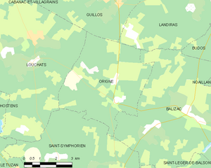
Origne
- commune in Gironde, France
- Country:
- Postal Code: 33113
- Coordinates: 44° 29' 33" N, 0° 30' 7" E
- GPS tracks (wikiloc): [Link]
- Area: 27.19 sq km
- Population: 181
- Web site: [Link]


Pujols-sur-Ciron
- commune in Gironde, France
- Country:
- Postal Code: 33210
- Coordinates: 44° 33' 43" N, 0° 21' 15" E
- GPS tracks (wikiloc): [Link]
- Area: 7.53 sq km
- Population: 780
- Web site: [Link]

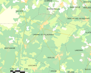
Cabanac-et-Villagrains
- commune in Gironde, France
- Country:
- Postal Code: 33650
- Coordinates: 44° 36' 24" N, 0° 33' 12" E
- GPS tracks (wikiloc): [Link]
- Area: 69 sq km
- Population: 2327
- Web site: [Link]

Budos
- commune in Gironde, France
- Country:
- Postal Code: 33720
- Coordinates: 44° 32' 0" N, 0° 23' 8" E
- GPS tracks (wikiloc): [Link]
- Area: 21.1 sq km
- Population: 775
- Web site: [Link]


Saint-Michel-de-Rieufret
- commune in Gironde, France
- Country:
- Postal Code: 33720
- Coordinates: 44° 37' 18" N, 0° 25' 55" E
- GPS tracks (wikiloc): [Link]
- Area: 18.94 sq km
- Population: 702
- Web site: [Link]
Illats
- commune in Gironde, France
- Country:
- Postal Code: 33720
- Coordinates: 44° 35' 51" N, 0° 22' 22" E
- GPS tracks (wikiloc): [Link]
- Area: 29.24 sq km
- Population: 1396
- Web site: [Link]


Guillos
- commune in Gironde, France
- Country:
- Postal Code: 33720
- Coordinates: 44° 32' 53" N, 0° 30' 9" E
- GPS tracks (wikiloc): [Link]
- Area: 22.67 sq km
- Population: 442
- Web site: [Link]


Saint-Morillon
- commune in Gironde, France
- Country:
- Postal Code: 33650
- Coordinates: 44° 38' 59" N, 0° 30' 10" E
- GPS tracks (wikiloc): [Link]
- Area: 20.4 sq km
- Population: 1636
- Web site: [Link]


Balizac
- commune in Gironde, France
- Country:
- Postal Code: 33730
- Coordinates: 44° 29' 15" N, 0° 26' 39" E
- GPS tracks (wikiloc): [Link]
- Area: 41.78 sq km
- Population: 493