Langenzersdorf (Langenzersdorf)
- municipality in Austria
 Hiking in Langenzersdorf
Langenzersdorf is a charming town located in Lower Austria, just a short distance from Vienna. Its scenic beauty and proximity to nature make it a great destination for hiking enthusiasts. Here are some highlights and tips for hiking in the Langenzersdorf area:
Hiking Trails
-
Wienerwald (Vienna Woods): Langenzersdorf is near the Wienerwald, a large forested area that offers numerous trails for various skill levels. You can find well-marked paths that provide both easy and challenging hikes through beautiful landscapes.
-
Danube River Trail: The stretch along the Danube River showcases stunning views, and the trail is mostly flat, making it suitable for families or those looking for a leisurely hike. You can also enjoy the riverside parks and historical sites along the way.
-
Kahlenberg and Leopoldsberg: For those looking for a more vigorous hike, consider heading to the nearby Kahlenberg or Leopoldsberg. These hills offer panoramic views of Vienna and the surrounding areas. The trails here can be steep but rewarding.
-
Local Nature Trails: Check out the local nature trails that may take you through vineyards, orchards, and small hills. These trails can offer a quieter hiking experience while still providing beautiful scenery.
Tips for Hiking in Langenzersdorf
- Stay Hydrated: Always bring enough water, especially during warmer months.
- Dress Appropriately: Wear comfortable hiking shoes and dress in layers, as weather can change quickly in the region.
- Trail Maps: Carry a detailed map or use a hiking app to stay on track, as some trails might not be well-marked.
- Respect Nature: Follow the Leave No Trace principles to preserve the natural beauty of the area.
- Local Regulations: Be aware of any local regulations regarding dogs on trails or picking plants.
Best Time to Hike
The best times for hiking in Langenzersdorf are spring (April to June) and autumn (September to October) when the temperatures are pleasant and the landscapes are vibrant with colors.
Accessibility
Langenzersdorf is easily accessible from Vienna by public transport, making it a convenient choice for day hikes. Buses and trains can take you to the starting points of various trails.
Whether you're an experienced hiker or a beginner looking for a nice walk in nature, Langenzersdorf provides an excellent backdrop for outdoor activities. Make sure to enjoy the scenery and the fresh air!
- Country:

- Postal Code: 2103
- Local Dialing Code: 02244
- Licence Plate Code: KO
- Coordinates: 48° 18' 25" N, 16° 21' 19" E


- GPS tracks (wikiloc): [Link]
- AboveSeaLevel: 170 м m
- Area: 10.7 sq km
- Population: 8137
- Web site: http://www.langenzersdorf.gv.at
- Wikipedia en: wiki(en)
- Wikipedia: wiki(de)
- Wikidata storage: Wikidata: Q675616
- Wikipedia Commons Category: [Link]
- Freebase ID: [/m/02qx9k7]
- GeoNames ID: Alt: [2772998]
- VIAF ID: Alt: [123361754]
- GND ID: Alt: [4127848-3]
- archINFORM location ID: [5966]
- Library of Congress authority ID: Alt: [n2004153870]
- MusicBrainz area ID: [3981744d-99fc-4cce-b0fa-1b977c6b6132]
- Austrian municipality key: [31214]
Shares border with regions:

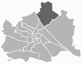
Floridsdorf
- 21. district of Vienna
Hiking in Floridsdorf
Floridsdorf is one of the 23 districts of Vienna, Austria, and while it is primarily an urban area, there are some lovely opportunities for outdoor activities and hiking in and around the district. Here are some highlights for hiking enthusiasts:...
- Country:
- Postal Code: 1210
- Licence Plate Code: W
- Coordinates: 48° 17' 0" N, 16° 24' 44" E
- GPS tracks (wikiloc): [Link]
- AboveSeaLevel: 159 м m
- Area: 44.52 sq km
- Web site: [Link]


Döbling
- 19. district of Vienna
Hiking in Döbling
Döbling is a charming district in Vienna, Austria, known for its scenic landscapes, vineyards, and proximity to the Vienna Woods (Wienerwald). Here are some highlights and tips for hiking in Döbling:...
- Country:
- Postal Code: 1190
- Licence Plate Code: W
- Coordinates: 48° 15' 59" N, 16° 19' 22" E
- GPS tracks (wikiloc): [Link]
- AboveSeaLevel: 247 м m
- Area: 24.9 sq km
- Web site: [Link]
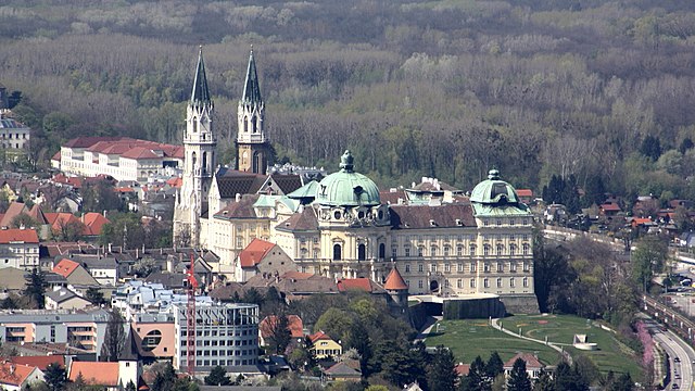

Klosterneuburg
- town in Lower Austria
Hiking in Klosterneuburg
Klosterneuburg, located just north of Vienna, Austria, offers a variety of beautiful hiking trails that cater to different skill levels and preferences. The region is characterized by its picturesque landscapes, historical sites, and proximity to the Vienna Woods (Wienerwald). Here are some highlights and tips for hiking in Klosterneuburg:...
- Country:
- Local Dialing Code: 02243
- Licence Plate Code: WU
- Coordinates: 48° 18' 15" N, 16° 19' 0" E
- GPS tracks (wikiloc): [Link]
- AboveSeaLevel: 192 м m
- Area: 76.2 sq km
- Population: 27058

Korneuburg
- municipality in Austria
Hiking in Korneuburg
Korneuburg, located just northeast of Vienna, Austria, offers some beautiful hiking opportunities with a mix of scenic landscapes, vineyards, and historical sites. Here are some highlights and tips for hiking in the Korneuburg region:...
- Country:
- Postal Code: 2100
- Local Dialing Code: 02262
- Licence Plate Code: KO
- Coordinates: 48° 20' 43" N, 16° 19' 59" E
- GPS tracks (wikiloc): [Link]
- AboveSeaLevel: 168 м m
- Area: 9.77 sq km
- Population: 12986
- Web site: [Link]

Bisamberg
- municipality in Austria
Hiking in Bisamberg
Bisamberg is a picturesque hill located just northeast of Vienna, Austria. It offers a variety of hiking trails that cater to different skill levels, making it a great destination for both casual walkers and more experienced hikers. Here are some key points to consider when hiking in Bisamberg:...
- Country:
- Postal Code: 2102
- Local Dialing Code: 02262
- Licence Plate Code: KO
- Coordinates: 48° 19' 53" N, 16° 21' 41" E
- GPS tracks (wikiloc): [Link]
- AboveSeaLevel: 192 м m
- Area: 10.74 sq km
- Population: 4729
- Web site: [Link]