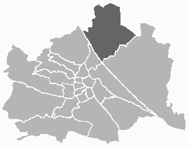
Floridsdorf (Floridsdorf)
- 21. district of Vienna
Floridsdorf is one of the 23 districts of Vienna, Austria, and while it is primarily an urban area, there are some lovely opportunities for outdoor activities and hiking in and around the district. Here are some highlights for hiking enthusiasts:
1. :
- This long, narrow island stretches along the Danube River and is a popular recreational area. It features extensive paths for walking and cycling, surrounded by beautiful natural scenery.
- There are designated walking routes and areas where you can enjoy the riverside views and various parks.
2. :
- Part of the Vienna Woods, Lobau is located nearby and is known for its natural landscapes, wetlands, and rich biodiversity.
- Various trails wind through the area, making it ideal for both short hikes and longer nature walks. You'll encounter diverse wildlife, including birds and plants, especially in the warmer months.
3. :
- While not directly in Floridsdorf, the Vienna Woods are easily accessible and offer a myriad of hiking trails. This forested area provides hills, scenic views, and a peaceful environment, perfect for a day hike.
- You can explore various trails that lead to viewpoints, historical sites, and even quaint villages.
4. :
- Floridsdorf has several smaller parks and green spaces where you can enjoy short walks or leisurely hikes. Look for areas like the Floridsdorf Park or the local forests surrounding the district.
Tips for Hiking in Floridsdorf:
- Footwear: Wear comfortable walking shoes or hiking boots, especially if you plan on venturing into nature reserves or the Vienna Woods.
- Hydration: Always carry water, particularly on warmer days.
- Weather: Check the weather forecast and dress appropriately for the conditions. Layers are key in managing temperature changes while hiking.
- Trail Maps: While some paths are well-marked, consider carrying a map or using a hiking app for navigation.
Overall, while Floridsdorf may not have rugged mountain trails, it offers some lovely options for enjoying nature on foot. Make sure to explore the nearby areas for a fuller hiking experience!
- Country:

- Postal Code: 1210
- Licence Plate Code: W
- Coordinates: 48° 17' 0" N, 16° 24' 44" E


- GPS tracks (wikiloc): [Link]
- AboveSeaLevel: 159 м m
- Area: 44.52 sq km
- Web site: http://www.wien.gv.at/bezirke/floridsdorf/
- Wikipedia en: wiki(en)
- Wikipedia: wiki(de)
- Wikidata storage: Wikidata: Q264645
- Wikipedia Commons Gallery: [Link]
- Wikipedia Commons Category: [Link]
- Freebase ID: [/m/05kwbl]
- GeoNames ID: Alt: [2779467]
- VIAF ID: Alt: [173669023]
- GND ID: Alt: [4079288-2]
- archINFORM location ID: [3701]
- Library of Congress authority ID: Alt: [n92038998]
- Austrian municipality key: [92101]
Shares border with regions:


Donaustadt
- 22. district of Vienna, Austria
Donaustadt is a district in Vienna, Austria, located along the banks of the Danube River. It offers a unique combination of urban and natural landscapes, making it an attractive destination for hikers. Here are some highlights and tips for hiking in Donaustadt:...
- Country:

- Postal Code: 1220
- Licence Plate Code: W
- Coordinates: 48° 13' 5" N, 16° 28' 59" E


- GPS tracks (wikiloc): [Link]
- AboveSeaLevel: 152 м m
- Area: 102.29 sq km
- Web site: [Link]


Leopoldstadt
- 2nd municipal District of Vienna, Austria
Leopoldstadt is the second district of Vienna, Austria, known for its vibrant culture, parks, and proximity to the Danube River. While it may not offer traditional hiking trails found in mountainous regions, there are still great opportunities for outdoor activities and leisurely walks....
- Country:

- Postal Code: 1020
- Licence Plate Code: W
- Coordinates: 48° 12' 37" N, 16° 24' 44" E


- GPS tracks (wikiloc): [Link]
- AboveSeaLevel: 158 м m
- Area: 19.27 sq km
- Web site: [Link]
Brigittenau
- 20. district of Vienna
Brigittenau is a 20th district of Vienna, Austria, situated on the northern banks of the Danube Canal. While it is an urban area and not traditionally associated with hiking, it still offers some opportunities for walking and enjoying the outdoors. Here are some aspects to consider if you’re interested in hiking or walking in and around Brigittenau:...
- Country:

- Postal Code: 1200
- Licence Plate Code: W
- Coordinates: 48° 14' 12" N, 16° 22' 10" E


- GPS tracks (wikiloc): [Link]
- AboveSeaLevel: 165 м m
- Area: 5.67 sq km
- Web site: [Link]


Döbling
- 19. district of Vienna
Döbling is a charming district in Vienna, Austria, known for its scenic landscapes, vineyards, and proximity to the Vienna Woods (Wienerwald). Here are some highlights and tips for hiking in Döbling:...
- Country:

- Postal Code: 1190
- Licence Plate Code: W
- Coordinates: 48° 15' 59" N, 16° 19' 22" E


- GPS tracks (wikiloc): [Link]
- AboveSeaLevel: 247 м m
- Area: 24.9 sq km
- Web site: [Link]


Lower Austria
- federated state of Austria
Lower Austria, known as Niederösterreich in German, is a fantastic destination for hiking enthusiasts. The region is characterized by its diverse landscapes, including rolling hills, vineyards, forests, and the scenic Danube River. Here are some highlights and popular hiking areas in Lower Austria:...
- Country:

- Capital: St. Pölten
- Coordinates: 48° 20' 0" N, 15° 45' 0" E


- GPS tracks (wikiloc): [Link]
- AboveSeaLevel: 279 м m
- Area: 19186.0 sq km
- Population: 1653419
- Web site: [Link]

