Langley (Langley)

- commune in Vosges, France
- Country:

- Postal Code: 88130
- Coordinates: 48° 21' 35" N, 6° 19' 30" E


- GPS tracks (wikiloc): [Link]
- Area: 2.73 sq km
- Population: 163
- Wikipedia en: wiki(en)
- Wikipedia: wiki(fr)
- Wikidata storage: Wikidata: Q836120
- Wikipedia Commons Category: [Link]
- Freebase ID: [/m/03qh9k_]
- Freebase ID: [/m/03qh9k_]
- GeoNames ID: Alt: [6445614]
- GeoNames ID: Alt: [6445614]
- SIREN number: [218802601]
- SIREN number: [218802601]
- BnF ID: [15279186n]
- BnF ID: [15279186n]
- INSEE municipality code: 88260
- INSEE municipality code: 88260
Shares border with regions:

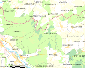
Damas-aux-Bois
- commune in Vosges, France
- Country:
- Postal Code: 88330
- Coordinates: 48° 23' 53" N, 6° 27' 7" E
- GPS tracks (wikiloc): [Link]
- Area: 29.46 sq km
- Population: 268


Essegney
- commune in Vosges, France
- Country:
- Postal Code: 88130
- Coordinates: 48° 22' 3" N, 6° 19' 0" E
- GPS tracks (wikiloc): [Link]
- Area: 8.41 sq km
- Population: 768


Portieux
- commune in Vosges, France
- Country:
- Postal Code: 88330
- Coordinates: 48° 20' 38" N, 6° 20' 41" E
- GPS tracks (wikiloc): [Link]
- Area: 7.9 sq km
- Population: 1265

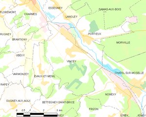
Vincey
- commune in Vosges, France
- Country:
- Postal Code: 88450
- Coordinates: 48° 20' 13" N, 6° 19' 43" E
- GPS tracks (wikiloc): [Link]
- Area: 12.81 sq km
- Population: 2209
- Web site: [Link]