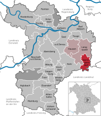
Langquaid (Langquaid)
- municipality in Germany
Langquaid, a charming village located in Bavaria, Germany, is surrounded by picturesque landscapes and offers a variety of hiking opportunities. The region is characterized by its rolling hills, meadows, and forests, making it a great destination for nature lovers and hiking enthusiasts.
Trails and Hiking Opportunities
-
Local Nature Trails: There are several well-marked trails around Langquaid that cater to various experience levels. These paths often take you through scenic farmland, alongside rivers, and through mixed forests.
-
The Danube River: Depending on how far you wish to wander, you can explore trails that lead you to the nearby Danube River. Walking along the river offers stunning views and a chance to enjoy the tranquil waterside environment.
-
Nature Parks: When you're in Langquaid, consider venturing slightly further to nearby nature parks. These areas often have extended hiking routes, wildlife observation opportunities, and more challenging terrains for those looking for a workout.
-
Seasonal Hiking: Each season offers a different experience. Spring brings blooming flowers, summer provides lush green trails, autumn offers vibrant foliage, and winter can provide opportunities for snowshoeing if conditions allow.
Preparation Tips
-
Maps and Guides: Always carry a map or a reliable hiking app to stay oriented. Information on local trails can sometimes be found at tourist information centers.
-
Footwear: Invest in a good pair of hiking boots for comfort and support, particularly on uneven terrains.
-
Weather: Check the local weather forecast before heading out for the day. Weather can change rapidly in different seasons, particularly in mountainous or hilly areas.
-
Safety: Always inform someone about your hiking plans, especially if you plan to trek alone. Carry a first aid kit and enough water and snacks to keep your energy up.
Conclusion
Hiking in and around Langquaid can be a delightful experience that immerses you in the natural beauty of Bavaria. Whether you opt for short nature walks or longer treks, there's plenty to explore. Enjoy your hiking adventure!
- Country:

- Postal Code: 84083–84085
- Local Dialing Code: 09452
- Licence Plate Code: KEH
- Coordinates: 48° 49' 0" N, 12° 3' 0" E


- GPS tracks (wikiloc): [Link]
- AboveSeaLevel: 389 м m
- Area: 56.77 sq km
- Population: 3777
- Web site: http://www.langquaid.de
- Wikipedia en: wiki(en)
- Wikipedia: wiki(de)
- Wikidata storage: Wikidata: Q524395
- Wikipedia Commons Category: [Link]
- Freebase ID: [/m/02q3rss]
- GeoNames ID: Alt: [2880597]
- VIAF ID: Alt: [127962489]
- OSM relation ID: [956648]
- GND ID: Alt: [4270870-9]
- archINFORM location ID: [14548]
- Library of Congress authority ID: Alt: [n89146890]
- Historical Gazetteer (GOV) ID: [LANAIDJN68AU]
- Bavarikon ID: [ODB_A00001496]
- German municipality key: 09273141
Shares border with regions:


Bad Abbach
- municipality in the district Kelheim, Bavaria, Germany
Bad Abbach, located in Bavaria, Germany, is known for its beautiful landscapes and proximity to the Danube River. Here are some highlights and tips for hiking in this region:...
- Country:

- Postal Code: 93074–93077
- Local Dialing Code: 09405
- Licence Plate Code: KEH
- Coordinates: 48° 56' 0" N, 12° 3' 0" E


- GPS tracks (wikiloc): [Link]
- AboveSeaLevel: 371 м m
- Area: 55.26 sq km
- Population: 12241
- Web site: [Link]

Teugn
- municipality of Germany
Teugn is a charming area in Bavaria, Germany, known for its scenic landscapes and outdoor activities, including hiking. Here are some key points about hiking in Teugn:...
- Country:

- Postal Code: 93356
- Local Dialing Code: 09405
- Licence Plate Code: KEH
- Coordinates: 48° 53' 35" N, 12° 0' 42" E


- GPS tracks (wikiloc): [Link]
- AboveSeaLevel: 388 м m
- Area: 17.07 sq km
- Population: 1220
- Web site: [Link]


Herrngiersdorf
- municipality of Germany
Herrngiersdorf is a small village located in Bavaria, Germany, and it offers a wonderful experience for hiking enthusiasts. While it may not be as renowned as other hiking destinations, its surrounding landscapes provide charming trails and a glimpse into the scenic beauty of the Bavarian countryside....
- Country:

- Postal Code: 84097
- Local Dialing Code: 09452
- Licence Plate Code: KEH
- Coordinates: 48° 48' 0" N, 12° 4' 0" E


- GPS tracks (wikiloc): [Link]
- AboveSeaLevel: 405 м m
- Area: 25.08 sq km
- Population: 1010
- Web site: [Link]

